
9.06.2018
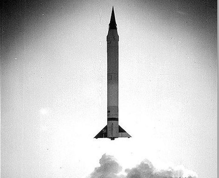
Launch of Viking 1, May 3, 1949. (NASM)
-
trivia question in the category of Space History: What was the first rocket designed and built specifically for spaceflight? The Soviet R-7 that delivered Sputnik 1 to orbit on October 4, 1957? No. The Jupiter-C that successfully launched America’s first satellite, Explorer 1, a few months later? Nope. Then surely it must be Germany’s V-2 missile, which reached the edge of space in vertical test flights during World War 2, and reached even greater heights over American deserts in the late 1940s.
No, wrong again.
All of these were designed originally as weapons of war. A close look at the historical record reveals that it was the lesser known Viking—originally built strictly as a “sounding rocket” for upper atmospheric research—that was the world’s first custom custom-made space launcher.
The story begins on October 3, 1942, almost exactly 15 years before the momentous launch of Sputnik 1. On that day Germany’s secret V-2 rocket (then designated the A-4) achieved its first successful vertical test flight from Peenemünde, off the Baltic coast, climbing to a record altitude of 84.5 kilometers, or 52.5 miles. Later that day, Walter Dornberger, the military commander of the high-tech complex where the A-4 had been developed, remarked: “This third day of October, 1942, is the first of a new era in transportation, that of space travel...”
But despite Dornberger’s recognition of the flight’s historic importance, the A-4 was being developed exclusively as a long-range missile, to be fired horizontally with a one-ton warhead on top. Even though later vertical test flights reached even higher, the A-4 was never meant to be a space vehicle.
After the war, using more than 100 V-2s captured from Germany, the U.S. military learned for the first time how to handle this revolutionary new technology—large-scale liquid-propellant rockets—which they fired from the White Sands Proving Grounds in New Mexico. Research institutions also were invited to place scientific instruments in the nosecones of these captured V-2s, to gather as much data as they could on the mysteries of the upper atmosphere and near space. These experiments were therefore the beginnings of space science.
But as the stockpile of captured V-2s dwindled, scientific organizations like the Naval Research Lab (NRL) in Washington, D.C., were anxious to find a replacement. The Lab’s Rocket Sonde Research Section got permission and funding from the Navy to contract the Martin Company of Baltimore—experienced aircraft manufacturers—to develop a large sounding rocket capable of lofting scientific payloads even higher than the V-2 could. Reaction Motors, Inc. (RMI) of New Jersey was subcontracted to build the 20,000-pounds-of-thrust engine for the new vehicle. When it came to picking a name, the project’s staff had a kind of contest, which was won by NRL’s Thor Bergstralh, whose Swedish parentage led him to propose “Viking,” after the early Scandinavian seafarers.
In those early post-war years, when spaceflight did not yet exist, there wasn’t even a clear definition of where “space” begins. The rocket’s developers used the term “upper atmosphere” to describe their destination. They knew the launcher would have to be made as light as possible, so the Viking was the first large rocket built entirely of aluminum, as opposed to steel for the V-2. As a result, even though the German rocket had twice the thrust, the Viking could reach much higher altitudes. The Viking also featured a unique, single-motor gimbaling system for maintaining stability during its ascent into the upper reaches. A total of 14 Vikings were built, each one different, as refinements were made to the design based on actual flight experience. Later Vikings featured unique, small hydrogen peroxide jets on the fin tips, for better control as the atmosphere got thinner near the boundary of space.
It was during this period, in fact, that the famed aerodynamicist Dr. Theodore von Kármán and his friend, the space lawyer Andrew G. Haley, realized that a better definition of “space” was needed. Von Kármán worked out the mathematics, while Haley concentrated on the legal language. By sheer coincidence, in early October 1957, just a couple of days after the launch of Sputnik 1 opened up the Space Age, Haley introduced his concept of the “Kármán jurisdictional line” at the 8th International Astronautical Federation Congress in Barcelona, Spain. This was the first attempt to define the demarcation between air and space—at an altitude of approximately 55 miles, where an airplane’s aerodynamic flight ceases. In fact, most nations already had legally recognized an altitude of 50 miles as the approximate beginnings of space.
However, four years later, after Yuri Gagarin made the first human spaceflight in April 1961, the Féderation Aéronautique International established a new boundary for any records pertaining to spaceflight. The FAI greatly rounded off von Kármán and Haley’s demarcation at 100 km (62 miles) and simply called it the “Karman line.” Today this line is generally accepted as the beginning of space, although everyone also understands that the atmosphere does not abruptly end at an exact height, and that the “boundary” changes constantly.
So, to return to our original trivia question, even though a captured V-2 technically reached space—peaking at 104 miles (167 km) in July 1946—the Viking was the first launcher built expressly for spaceflight. And the record shows that it more than accomplished this goal.
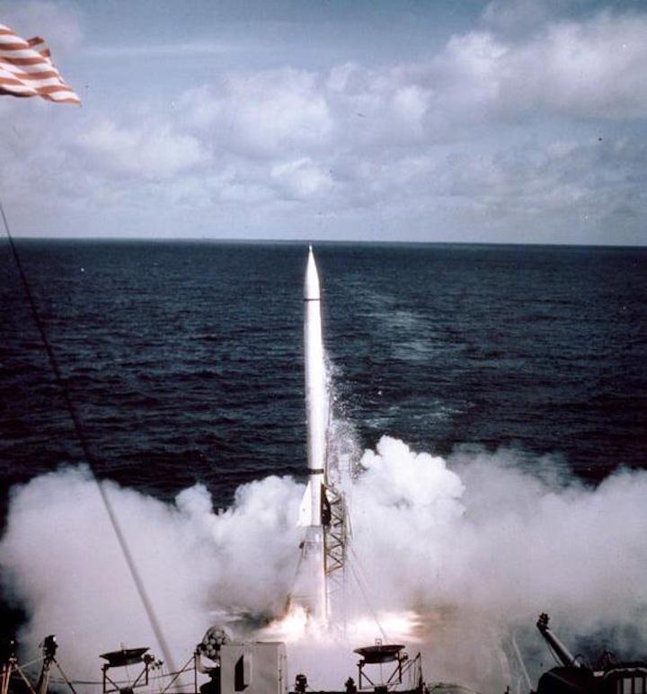
Launch of Viking 4 from USS Norton Sound, on May 11, 1950. (NASM)
-
The first three, starting in 1949, had technical problems, but on May 11, 1950, Viking No. 4—the only one launched from a ship, near Christmas Island in the Pacific Ocean—was the first to cross the “Karman line” and climb to 106.8 miles (168 km). Most of the rest of the Vikings were launched from White Sands. Number 7, launched in August 1951, set a new world’s record for a single-stage rocket at 136 miles (218 km). Number 11, in May 1954, broke it again by reaching 158 miles (255 km), and achieved the first reentry from space when its detachable nosecone came down with the help of its new small hydrogen peroxide steering thrusters. Photos taken on the flight also showed, for the first time, our planet Earth as a sphere.
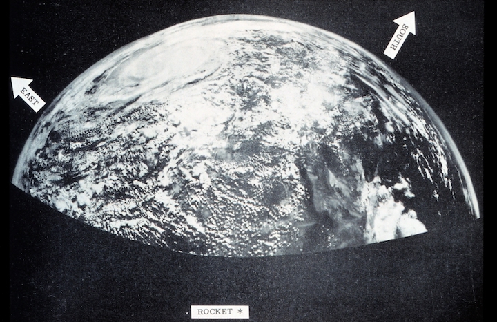
Earth as seen from Viking 11 in 1954. (NASM)
-
The final two Vikings became space vehicles in another sense, since they were used in tests for Project Vanguard, the first U.S. program designed to place a satellite in orbit. In December 1956, the refurbished Viking No. 13—also designated TV-0 (Test Vehicle-0)—made a night launch from Cape Canaveral, Florida, mainly to test the tracking system for Vanguard. Then, in May 1957, Viking 14 (re-designated TV-1) was fitted with a second stage that tested the solid-propellant motor that afterwards became the third stage for the operational Vanguard vehicle. That last Viking was the ninth to go into space. Vanguard 1 finally reached orbit in March 1958, and the Vikings had figured prominently in its success.
Although little remembered today, Viking No. 11’s then-stunning high-altitude flight was widely covered on TV at the time, and the launch helped to demonstrate the promise of spaceflight. Recovered parts of the rocket were incorporated into a reconstruction of a full-size launcher exhibited at the Hayden Planetarium in New York City from 1955 to 1957, which may have been the world’s first museum exhibition of rocket parts actually flown in space. In 1974, 17 years after the Hayden exhibit closed, this same reconstructed Viking was donated to the Smithsonian. Today the cut-away rocket (although now painted as Viking No. 12) can still be seen in the National Air and Space Museum’s “missile pit,” an important artifact from the early, pioneering days of spaceflight.
Quelle: Air&Space Magazine
+++
First Photo From Space
In 1946, rocket-borne cameras gave us our first look at Earth from beyond the atmosphere
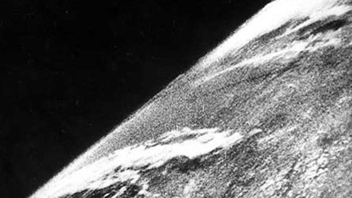
View of Earth from a camera on V-2 #13, launched October 24, 1946. (White Sands Missile Range/Applied Physics Laboratory)
-
On October 24, 1946, not long after the end of World War II and years before the Sputnik satellite opened the space age, a group of soldiers and scientists in the New Mexico desert saw something new and wonderful—the first pictures of Earth as seen from space.
The grainy, black-and-white photos were taken from an altitude of 65 miles by a 35-millimeter motion picture camera riding on a V-2 missile launched from the White Sands Missile Range. Snapping a new frame every second and a half, the rocket-borne camera climbed straight up, then fell back to Earth minutes later, slamming into the ground at 500 feet per second. The camera itself was smashed, but the film, protected in a steel cassette, was unharmed.
Fred Rulli was a 19-year-old enlisted man assigned to the recovery team that drove into the desert to retrieve film from those early V-2 shots. When the scientists found the cassette in good shape, he recalls, “They were ecstatic, they were jumping up and down like kids.” Later, back at the launch site, “when they first projected [the photos] onto the screen, the scientists just went nuts.”
Before 1946, the highest pictures ever taken of the Earth’s surface were from the Explorer II balloon, which had ascended 13.7 miles in 1935, high enough to discern the curvature of the Earth. The V-2 cameras reached more than five times that altitude, where they clearly showed the planet set against the blackness of space. When the movie frames were stitched together, Clyde Holliday, the engineer who developed the camera, wrote in National Geographic in 1950, the V-2 photos showed for the first time “how our Earth would look to visitors from another planet coming in on a space ship.”
It was one of many firsts for the V-2 research program of the late 1940s, during which the Army fired dozens of captured German missiles brought to White Sands in 300 railroad cars at the end of the war. While the missileers used the V-2s to refine their own rocket designs, scientists were invited to pack instruments inside the nosecone to study temperatures, pressures, magnetic fields and other physical characteristics of the unexplored upper atmosphere.
Holliday worked for the Johns Hopkins University Applied Physics Laboratory (APL), alongside pioneering space scientists like James Van Allen and S. Fred Singer, both of whom would later be involved in planning the first U.S. satellites. Singer—better known today as a dogged skeptic of global warming with the Science and Environmental Policy Project in Arlington, Virginia—would analyze the photos that came back from the V-2 cameras to determine the rocket’s orientation to the Earth, a job he remembers as “quite difficult.” The missile engineers needed to know how the rocket was steering through the upper atmosphere, and the scientists wanted to determine from which direction cosmic rays hitting their instruments were coming. Hardly anyone was interested in what the pictures revealed about geography or meteorology, at least not at first. “We considered clouds to be a nuisance,” says Singer.
But Holliday, an instrument specialist at APL, well understood the importance of the photos for the study of Earth. Cy O’Brien, who worked in the lab’s public affairs office beginning in 1950, says Holliday was “in an environment with super-Ph.D.s, and he wanted to make clear that photography was a science, too.”
Holliday’s discussion of the photos therefore leaned toward the technical. In those days before Walt Disney and Collier’s magazine planted the idea of space exploration in the public imagination, he was even sparing with his use of the term “space.” The V-2 photos, he wrote in 1950, were taken in “the little-known reaches of the upper air.” Today, even though the definition is somewhat arbitrary, anything above 100 kilometers (62.5 miles) is considered space.
More than 1,000 Earth pictures were returned from V-2s between 1946 and 1950, from altitudes as high as 100 miles. The photos, showing huge expanses of the American southwest, appeared in newspapers and were scrutinized by scientists from the U.S. Weather Bureau. In his National Geographic article, Holliday offered a few predictions as to where it all might lead: “Results of these tests now are pointing to a time when cameras may be mounted on guided missiles for scouting enemy territory in war, mapping inaccessible regions of the earth in peacetime, and even photographing cloud formations, storm fronts, and overcast areas over an entire continent in a few hours.” Going out on a limb, he speculated that “the entire land area of the globe might be mapped in this way.”
Fred Rulli, the former member of the camera recovery team, now counts himself lucky to have been in the “select group” that saw the first pictures from space as they came in. At 19, it seemed to him like just another Army job. But he recalls a friend at White Sands, another soldier—60 years later he’s forgotten his name—who was more alive to the future unfolding in front of them. Pointing to the rockets, the scientists and the clear New Mexico sky, the friend would turn to Rulli and say with amazement, “Do you realize what’s going on here?”
Quelle: Air&Space Magazine