
7.08.2020
A new set of images captured this spring by the Colour and Stereo Surface Imaging System (CaSSIS) on the ESA-Roscosmos ExoMars Trace Gas Orbiter shows a series of interesting geological features on the surface of Mars, captured just as the planet passed its spring equinox.
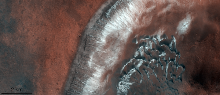
Dune fields in the Green Crater of Mars
The image above, taken on 27 April 2020 and centred at 52.3°S, 351.8°E, shows part of an impact crater located inside the larger Green Crater in the Argyre quadrangle in the southern hemisphere of Mars.
The image reveals an almost black dune field on the right surrounded by red soils, partially covered with bright white ice. Gullies, also partially covered with ice, are visible in the crater wall in the centre of the image. Scientists are currently investigating the relationship between this seasonal ice and the presence of the gullies. The image was taken just after the spring equinox in the southern hemisphere of Mars, when the southernmost part of the crater (to the right) was almost completely free of ice while the northern part (centre) was still partially covered. The southern crater wall has had a longer exposure to the Sun (like on Earth, equator-facing slopes receive more sunlight), so the ice in this area has receded faster.
Leaf-like structures in Antoniadi impact crater
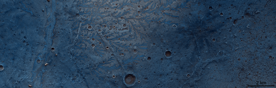
This image, captured on 25 March 2020, shows the bottom of the 400 km in diameter Antoniadi impact crater, which is located in the northern hemisphere of Mars in the Syrtis Major Planum region. The blue colour of the image, centred at 21.0°N, 61.2°E, does not represent the real colour of the crater floor but highlights the diversity of the rock composition inside this impact crater.
In the centre of the image are dendritic structures which look like the veins on oak leaves. These structures, evidence of ancient river networks in this region, protrude from the surface, unlike channels, which are usually sunken in the surface. This is because the channels were filled with harder material – possibly lava – and over time the softer rocks surrounding these branching channels have been eroded, leaving an inverted imprint of this ancient river system.
Argyre impact basin after spring equinox
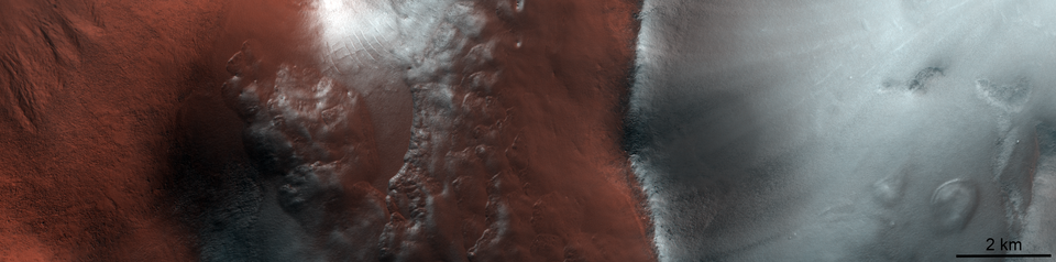
This image of the Argyre impact basin in the southern highlands of Mars was taken on 28 April 2020 just as Mars had passed its southern hemisphere spring equinox. The seasonal ice in the 800km-long impact basin is visibly receding while the ridge on the right side of the image is still covered with frost. The image is centred at 57.5°S, 310.2°E. The frost-covered ridge is facing the pole, therefore receiving less solar radiation than the neighbouring equator-facing slope. On Mars, incoming solar radiation transforms the ice into water vapour directly without melting it first into water in a process called sublimation. Since the north-facing slope (on the left) has had a longer exposure to solar radiation, its ice has sublimated more quickly.
Rock composition in Ius Chasma canyon
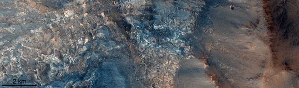
The image taken on 5 May 2020 shows a part of the floor of the Ius Chasma canyon, part of the Valles Marines system of canyons that stretches nearly a quarter of the circumference of Mars south of the planet's equator. The Ius Chasma canyon, which can be seen in the image rising up to a ridge on the right side, is about 1000 km long and up to 8 km deep, which makes it more than twice as long and four times as deep as the famous Grand Canyon in the US state of Arizona. The centre of this image is located at 8.8°S, 282.5°E.
The beautiful colour variations across the floor of Ius Chasma are caused by changes in rock composition. Scientists theorise that the light rocks are salts left behind after an ancient lake evaporated. The information about the rock's composition is useful to scientists as it allows them to retrace the formation history of the canyon.
Quelle: ESA