
13.07.2020
Long before we had satellites beaming terabytes of data back to Earth, we had covert spacecraft the size of school buses snapping photos on rolls of film 50 kilometers long.
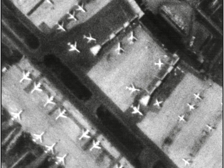
Caught on camera: Planes parked at the Domodedovo Airport near Moscow on 6 April 1979, as seen by a KH-9 Hexagon spy satellite. Credit: National Reconnaissance Office
A parachute descends toward Earth, carrying over 200 kilograms of black-and-white film. A United States Air Force C-130 cargo plane flies nearby, ready with a series of hooks and cables to catch the parachute in midair and hoist in its payload. The pilots must be careful, though: The capsule contains classified images destined for Washington, D.C.’s top brass.
The load was one more delivery from KH-9 Hexagon, a spy satellite program launched by the U.S. National Reconnaissance Office (NRO) to surveil the Soviet Union between 1971 and 1986. Hexagon was just one in a line of covert Cold War missions managed by U.S. intelligence services, and some credit these services for helping the superpowers avoid engaging in direct conflict.
In 2002, the U.S. government declassified the images from Hexagon, and since then, scientists have mined the photos to reveal changes in the world around us.
The declassified images are incredibly detailed. Phil Pressel, who worked as an engineer for the company that designed Hexagon’s cameras, said the images were “much better than Google Earth.” The cameras captured objects as small as 0.6 meter wide and shot the scenery from an angle, instead of like other satellites that imaged the Earth directly from above. Scientists have created three-dimensional landscapes from overlapping Hexagon images and used them as historical data in their studies.
The images show a time before decades of melt, wildfires, and erosion. The photos are time capsules, and scientists have made countless discoveries with them, including five given here.
1. Himalayan Glaciers Are Rapidly Melting

Glacial melt in the Himalayas is notoriously difficult to track. Unlike Alaskan glaciers, which recede laterally as they melt, Himalayan glaciers grow shallower. Measuring the change is tricky.
Now scientists can estimate the glacier’s surface change using Hexagon images. By digitizing the overlapping photos, researchers created a digital elevation model of the glaciers in the 1970s.
Comparing the elevation of the glaciers then with current measurements, researchers found that the glaciers have lost more than a quarter of their ice mass since 1975. The glaciers in their study account for about half the glacial mass in the Central Himalayas and serve as a bellwether for the region.
The pace of melt is accelerating, too. The glaciers melted by a quarter of a meter between 1975 and 2000. Since then, the rate has doubled.
2. Reindeer Are Losing Herding Ground in Finland
Hexagon can reveal impacts to species, too. Reindeer herding in northern Finland has been a way of life for centuries, but modern industry is blocking migration corridors and squeezing herds into smaller habitats.
A collection of remote sourcing data, including from Hexagon, revealed that about a quarter of at least one of Finland’s herding districts has been disrupted since the late 1960s, according to one study.
A few human-caused changes are responsible for shrinking the reindeer’s range. Clear-cutting forests threatens the reindeer’s only source of food during winter: lichens that grow on the ground of old-growth forests. And more than a thousand kilometers of newly built roads and hydroelectric reservoirs also bisect land and make poaching easier.
Without a diverse expanse of pastures and forests to graze on, the reindeer could be more vulnerable to short-term changes in climate and land use.
3. Landslides Are Encroaching on Farms in Peru
In another study, scientists used Hexagon images to track down the culprit of a local hazard. In the fertile Vitor and Siguas Valleys in southwestern Peru, farmers are losing land from a slow moving menace: landslides. The valley walls are falling in on themselves, and slow moving landslides have covered 7% of the valley floor in the past 4 decades, destroying traditional farms.

Scientists turned to satellite images from Hexagon and the commercial satellites SPOT-6 and SPOT-7 to track down the source of the slides. Poring over the images from 1978 to 2016, they found that landslides show up under irrigated farms. The plateau above the valley has an increasing number of large-scale agricultural projects, and the practice is destabilizing slopes. Unfortunately, now that earth on the slopes is unstable, it will continue to move.
But future damage could be avoided, the authors wrote, if farms use water more efficiently.
4. Seismic Hazards Have Been Uncovered in Eastern Iran
Hexagon can help scientists reconstruct the details of a catastrophe to help avoid future ills.
On 16 September 1978, a slumbering tectonic fault awoke in eastern Iran. The Mw 7.8 earthquake destroyed the nearby town of Tabas and killed 85% of its population, about 11,000 people. The event was the first of its kind in that area for at least a thousand years.
Mapping ground change after a quake helps researchers understand how faults behave and guess when another earthquake could strike. But scientists didn’t have GPS trackers on the ground before the quake.
Using Hexagon, SPOT-2, and SPOT-6, a team of researchers mapped the horizontal displacements of the ground before and after the earthquake. From their calculations, they guessed that an Mw7.8 quake would occur about every 3,500 years.
5. A Volcano Is on the Move in Iceland

The classified images made up for a lack of instruments on the ground during a volcanic eruption, too.
One of the largest eruptions in Iceland’s history began at Krafla in 1975, when the volcano erupted nine times over the course of a decade. The eruptions caused earthquake swarms, ground swelling, and widened fissures. Regrettably, scientists captured only a few measurements during the crisis.
Scientists used Hexagon, SPOT-5, and aerial photos to rewind the clock. The eruption caused an opening of about 8 meters near the caldera that narrowed to about half that size farther up the rift. The results suggest that Krafla could have pulled from two different magma sources or that the rift has heterogeneous rock strength.
As Earth continues to shift, the Hexagon images will remain a stake in the sand for global change for decades to come.
Quelle: Eos American Geophysical Union