
18.04.2023
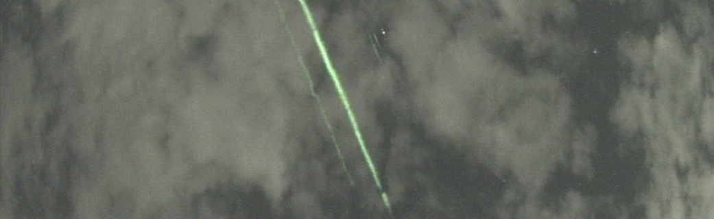
The green light streaking across the cloudy sky was something that Daichi Fujii had never seen before. The museum curator's motion-detecting cameras were set up near Japan’s Mount Fuji to capture meteors, allowing him to calculate their position, brightness, and orbit. But the bright green lines that appeared on a video taken Sept. 16, 2022, were a mystery.
Then Fujii looked closer. The beams were synchronized with a tiny green dot that was briefly visible between the clouds. He guessed it was a satellite, so he investigated orbital data and got a match. NASA’s Ice, Cloud and Land Elevation Satellite 2, or ICESat-2, had flown overhead that night. Fujii posted his findings on social media, which eventually got the attention of the NASA team.
It’s the first time the ICESat-2 team has seen footage of the satellite’s green laser beams streaming from orbit to Earth, said Tony Martino, ICESat-2 instrument scientist at NASA’s Goddard Space Flight Center in Greenbelt, Maryland.
“ICESat-2 appeared to be almost directly overhead of him, with the beam hitting the low clouds at an angle,” Martino said. “To see the laser, you have to be in the exact right place, at the right time, and you have to have the right conditions.”

ICESat-2 was launched in September 2018 with a mission to use laser light to measure the height of Earth's ice, water, and land surfaces from space. The laser instrument, called a lidar, fires 10,000 times a second, sending six beams of light to Earth. It precisely times how long it takes individual photons to bounce off the surface and return to the satellite. Computer programs use these measurements to calculate ice losses from Greenland and Antarctica, observe how much of the polar oceans are frozen, determine the heights of freshwater reservoirs, map shallow coastal regions, and more.
Fired from hundreds of miles up in space, the laser light is not harmful. In fact, it’s tricky to spot. If someone stood directly under the satellite and looked up, the laser would have the strength of a camera flash more than 100 yards away, Martino said.
People have tried to photograph the satellite when it passed over, and in a couple instances they were able to capture photos – once from southern Chile and once from Oklahoma.
The beam is even more difficult to capture, he noted, since cameras and eyes need the laser light to reflect off something to see the beam from the side. That’s where the atmospheric conditions come in.
On the night ICESat-2 passed over Fuji City, however, there were enough clouds to scatter the laser light – making it visible to the cameras – but not so many clouds that they blocked the light altogether. There were actually two thin layers of clouds over Japan that night – information Martino found by analyzing the ICESat-2 data, which shows clouds as well as the ground below.
With the precise location of the satellite in space, the location of where the beam hit, the coordinates of where Fujii’s cameras were set up, and the addition of cloudy conditions, Martino was able to confirm, definitively, that the streaks of light came from ICESat-2’s laser.
By Kate Ramsayer
NASA's Goddard Space Flight Center, Greenbelt, Md.
Header caption: On Sept. 16, 2022, a homemade motion detecting camera set up by Daichi Fujii near Mount Fuji, Japan, captured green laser light from NASA's ICESat-2 satellite. It’s the first time the ICESat-2 team has seen footage of the lidar instrument at work. The satellite has six beams; the left-most beam in the image is Beam 4, the stronger beam next to it is Beam 3. The two shorter and fainter green streaks in the image are the beams scattering off higher clouds, and the dot that appears next to those faint streaks is the ICESat-2 satellite. Courtesy of Daichi Fujii/Hiratsuka City Museum
Quelle: NASA