

"GO FAST" Footage from Tom DeLonge's To The Stars Academy. Bird?
+++
To confidently recreate the scene in 3D I really am going to need that cmos/ccd image sensor size.
Here is the first stage at setting up the 3D. For now the camera is just perpendicular to the ocean surface and I started with plugging in 1050mm for the focal length, you can see the camera settings highlighted in red.
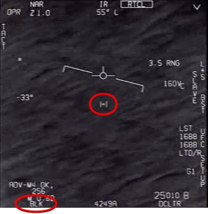
Also, I saw the RNG in some of the math equations, can someone explain what it is? And what is the Vc?
![[IMG]](https://www.metabunk.org/data/MetaMirrorCache/02c490bcd4f6f8072c18f3ba1ccc21e5.jpg)
![[IMG]](https://www.metabunk.org/data/MetaMirrorCache/cde729ee30c10e5bce7a0cddf5c95118.jpg)
+++
RNG is the distance to the target, presumably in nautical miles
Vc is the closing velocity, presumably in knots. i.e. the component of the relative velocity of the object parallel to the line of sight.
+++
o from what I can work out the ATFLIR is modelled in the F/A18 Hornet pack for flight sims https://www.vrsimulations.com/superbug.php so the devs know the specs.
+++
No I don't think that is what is implied. A typical ascent rate would be around 5 m/s although it can be adjusted by the amount of gas it is filled with. In strong winds you might want to overfill it so that it does not disappear behind a mountain, for example. The ascent rate is independent of wind speed, although its actual velocity is the vector sum of the vertical ascent rate and horizontal wind velocity.
+++
Correct. I estimated around 6 feet.
+++
It's cooler because it's higher, in cold air, and any source of heat is either hidden, insulated, or there is no source of heat. This could happed in different ways:
1) Helium Balloon - no source of heat, so it's the same temp as the air at 13,000 feet.
2) Bird - internal heat, but possibly insulated and masked by feathers which are cold, as they are in cold air
3) Small plane - Engine heat, cabin heat, and exhaust heat. Unlikley to show up as cooler than the Ocean, but perhaps possible at a distance with the high wing hiding most of the heat sources, so on average it's cooler.
I'd lean towards that order for probability. I'm torn between bird and balloon as a balloon fits the temperature profile better, and the shape. But there's a lot more birds than balloons.+++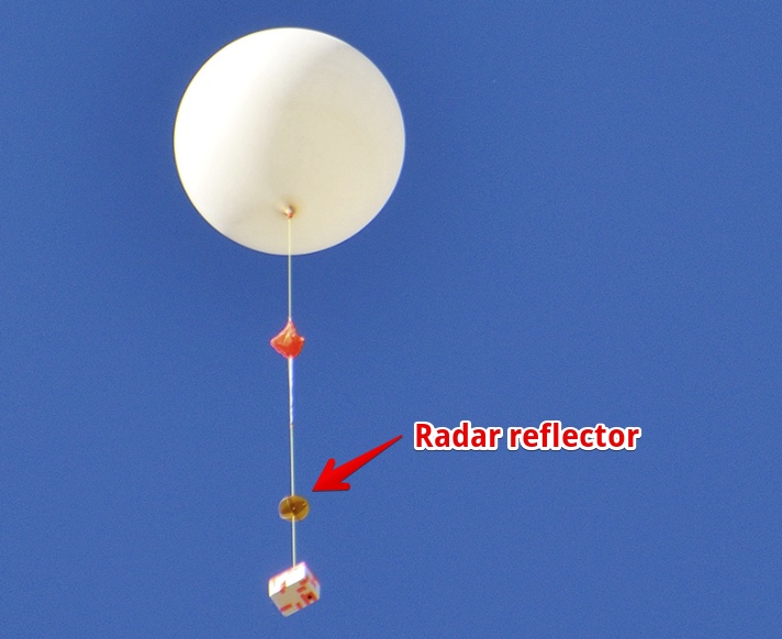
But how does the RNG measurement actually work? I'd assume the tracking was image based, is there image based tracking and a radar based distance measurement? Or laser based? The radar reflectors are pretty shiny, so I'd assume the would work well with lasers.++++++Does the range come from the radar or from ATFLIR's laser rangefinder, since it's displayed when ATFLIR locks on to the target? I don't know if the radar would pick up a bird or a balloon.
Edit: Of course the radar would pick up the radar reflectors carried by a balloon.+++A method just occurred to me - image tracking in Adobe After Effects
You can then click on the feature center in the the timeline, Copy, then paste into Excel. Repeat for second feature center. Calculate angle. Done!
https://www.metabunk.org/attachments/go-fast-tilt-tracking-xlsx.32275/+++There's clearly a bit of feature center drift there though, you can see it in the two images. However I think it's accurate to within 1°
I'd be concerned about the accumulation of errors though, if you use a non-zero value when the plane is not really turning.+++Well, I meant the surrounding environment. However, FLIR cameras can detect invisible warmer gases, and the atmosphere is gases.
http://www.flirmedia.com/MMC/THG/Brochures/T820433/T820433_EN.pdf#page=4
And isn't the temperature we're seeing on the ocean the reflection of the temperature of the sky, not the ocean itself? That's what someone said previously in this thread. Agent K posted this...
There's more warmth in the sky near the horizon, and I suspect the thermal variation seen in the waves of the Go Fast video is caused by the slanted angles of the waves reflecting more of the warmer horizon than the cooler sky directly above. Looking at the horizon we're actually looking through a thicker volume of atmosphere than when we look straight up, and the atmosphere is warmer than outer space. So I suspect FLIR cameras do detect the temperature of the atmosphere when aimed at a sufficiently expansive volume of it.+++
I also realised that we need to know the angle the aircraft turned during the 19 seconds it was locked onto to. I drew a 3D drawing assuming the aircraft flew straight and level, I did this to check the parallax only. But then realised this can tell us its turn angle. Bank angle and turn rate are two different things and the factors are many and varied why that would not equate.
I found from my parallax ground track, that if the aircraft were flying straight and level at the end, the sea surface should be crossing the frame at an angle of 34 degrees. But in the video it is crossing at an angle of 55 degrees at the end and 63 degrees at the start. taking this back to the drawing I created a curve that matched these figures, so the ground track on the drawing matched the track on the video at both positions. I found that the best match was when the aircraft turned by 5 degrees.
Putting that curve into Mick's graph, this places the object at almost the shortest distance from the original point. Meaning it was moving very slow at only 34 knots.+++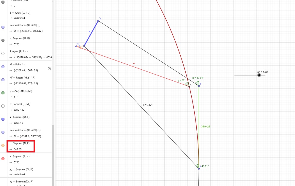 +++Excellent work. Keep this analysis bookmarked. There will always be accumulation of errors, but this is the best method presented so far!
I just wrote a script that converts the roll angle to acceleration assuming that the pilot is keeping a coordinated turn keeping the total acceleration (gravity + acceleration) orthogonal to the wings.
if a, v, and p are acceleration, velocity, and position, then we can numerically integrate as follows:
Let G = 9.8 m/s^2
initialize v and p appropriatly then repeat the following steps:
roll = next roll angle
acc = -tan(roll) * G
solve for a as a coordinated turn.
v = v + a * dt
p = p + v * dt
I'll post the results as soon as I get them.+++Couldn't have been a less painless process.
Apologies if this is off topic.+++![[IMG]](https://www.metabunk.org/data/MetaMirrorCache/a6d3cda630ce4b11b07e722cb3ec045d.gif)
Next I'll stabilize the second non-track-locked segment, which shows a more curved path in the original footage.+++@Mick West was kind enough to pull out the roll data from the artificial horizon.
Here is the track with the roll information included (assuming coordinated turns as previously described).
When I assume a crosswind of 100 kts the object speed is only about 50 kts.
And zoomed in, in 3D the object motion looks pretty random.
Here is the raw data:
Try the code again @Mick West , it should all work for you except for the 3D plots.+++Tilt your head to left, the horizon tilts down to the right. The plane is represented in the middle of the artificial horizon. It does not move because the screen is moving with the plane.
It's easier to visualize this if you hold your cellphone camera at arms length and then tilt your head and camera together. Bonus points if you use a theodolite app.+++Here's the second segment with non-locked tracking at half speed stabilized to the ocean.
Here's this same segment with overlaid path map not stabilized...
Go Fast's true trajectory looks to be straight during both non-locked-tracking segments. There's some fine zig-zagness to the path here, but I suspect that's interlacing noise in the video. In these snippets I see no indication that the object is being consciously steered, it could be a wind-blown weather balloon looking to go faster than it is due to parallax.+++I’ve been conversing with Garry Nolan on the TTSA Facebook group page and he has raised some issues and questions about the conclusions of the altitude of the object being so high ca, 13,000 feet. He states that the object is moving along about 100 feet above the ocean surface. I told him I would copy his comment for you here:
![[IMG]](https://www.metabunk.org/data/MetaMirrorCache/1e28d0453fca4353845d43236425369a.jpg)
5634 Views