
12.06.2022
Mars, Earth's neighbouring planet, is not particularly known for its colourful appearance. It is usually thought of as an orange-brown expanse, stretching as far as the eye - or at least the cameras on rovers and spacecraft - can see. But there are landscapes that are a veritable kaleidoscope of colour by Martian standards. One such area has been captured in the latest images from DLR's Mars camera. These were created using data acquired over the southern highland region of Aonia Terra and show various hues, ranging from black to grey, red, beige and almost white. The different colours indicate a variety of mineralogical compositions in the surface material, which is very diverse here.
The High Resolution Stereo Camera (HRSC), which has been mapping the planet on board ESA's Mars Express spacecraft since 2004, was developed at the German Aerospace Center (Deutsches Zentrum fur Luft- und Raumfahrt; DLR) and is operated by the DLR Institute of Planetary Research in Berlin-Adlershof. The data it acquires are an important resource for current and future Mars research.
Aonia Terra is located in the southern highlands of Mars. It is known for its many craters - such as the 200-kilometre Lowell Crater (see the overview map, image 3). The southern highlands are among the oldest formations on the planet, and were formed 3.8 to 3.5 billion years ago, during the Noachian Period. The age of a planetary surface can be determined through statistical analysis of the different crater sizes and how frequently they occur. The older a region is, the more craters it will have and the greater number of large craters there will be. Using this method, scientists have been able to determine three different periods of Martian history - the Noachian (4.1 to 3.7 billion years ago), the Hesperian (3.7 to 3.3 billion years ago) and the Amazonian (from 3.3 billion years ago to the present day).
Rain and groundwater created numerous valleys a long time ago
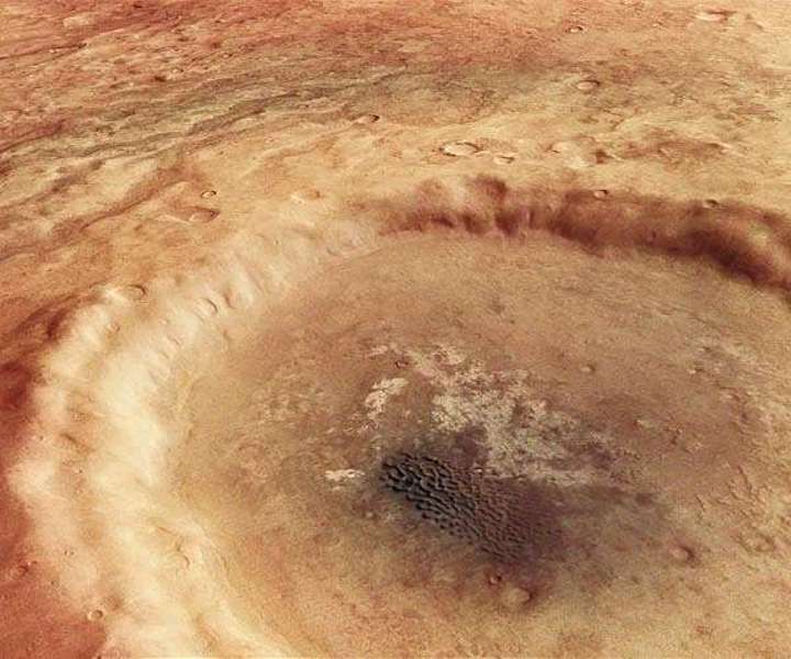
The unnamed crater at the centre of the images is 30 kilometres in diameter and lies within a network of channel-like valleys. These valleys were most likely created by a combination of surface rainwater runoff and groundwater outflow during the late Noachian to early Hesperian periods.
Interestingly, dark material can be seen at the bottom of some of these valleys. In some places, the relief of the valleys has actually reversed; due to backfilling, the valley floors now rise above the surrounding landscape. This occurs when the material that filled in the valleys is more resistant to erosion than the landscape surrounding them. Such materials may have become more compacted and resistant over time due to the effect of water (geochemical cementation), or they may consist of erosion-resistant, often coarse-grained sediments. However, it is also possible that lava flowed into these valleys at a later time.
The surface around the impact crater is made up of different materials. South of the crater (on the left in image 1), the surface is a warm shade of red, which changes to dark brown and grey the closer one gets to the crater. There are numerous small buttes in this region. Looking further north, the surface looks as though it has been smoothed out, as is clearly visible around the crater rims. Here the colour of the landscape becomes lighter, and the edges of the channels are less well defined. Finally, on the far right-hand side of the image, the surface looks much smoother. The different colours indicate that the mineralogy of the surface is highly varied.
Black dunes like Hawaii
It is possible to make out a black dune field inside the impact crater. This is made up of small crescent dunes, some of which have merged together. Measuring 5.4 by 2.7 kilometres, it sits atop a light-coloured deposit that was probably formed by weathering in combination with water. The black sands are known to be volcanic in origin because they are made up of minerals that could only have been brought to the surface of Mars by volcanism.
Their composition also closely resembles that of volcanic ash on Earth. They are referred to as basaltic dunes because they are composed of volcanic minerals and can be found in many places on Mars. Basalts are the most common volcanic rocks on Mars. On Earth, there are only a few instances of these dark dunes, for example in Hawaii, as they only exist where volcanic activity takes place in a dry climate.
On closer inspection, one can also discover many small hills and elevations away from the dune field on the crater floor, which stand like knolls in the landscape. This shows that the interior of the crater also consists of many different materials that have come together here. Measurements by the Thermal Emission Imaging System (THEMIS) instrument on board NASA's Mars Odyssey spacecraft reveal that the bright deposits have very high thermal inertia, while the remaining material on the crater floor has very low thermal inertia. Thermal inertia is a measure of the consolidation of a material, with high thermal inertia indicating solid rock and low thermal inertia indicating loose material. These different properties confirm the large differences in the composition of the crater infill.
Image processing
The images shown here were created using data acquired by the High Resolution Stereo Camera (HRSC) on 25 April 2022 during orbit 23,137 of the Mars Express spacecraft around the Red Planet. The image resolution is approximately 14 metres per pixel. The centre of the images is located at approximately 282 degrees east and 48 degrees south. The perpendicular colour view (image 1) was created using data from the nadir channel, the field of view of which is directed perpendicular to the Martian surface, and the colour channels of HRSC.
The oblique perspective views (images 2 and 4) were computed using data from the stereo channels of HRSC. The anaglyph image (image 5), which gives a three-dimensional impression of the landscape when viewed with red-blue or red-green glasses, was created using data from the nadir channel and stereo channels. The colour-coded topographic view (image 6) is based on a Digital Terrain Model (DTM) of the region, from which the topography of the landscape can be derived. The reference body for the HRSC DTM is an equipotential surface of Mars (areoid).
The systematic processing of the camera data was carried out at the DLR Institute of Planetary Research. Personnel in the Department of Planetary Sciences and Remote Sensing at the Freie Universitat Berlin used these data to create the image products shown here.
Quelle: SD