
5.09.2019

› Full image and caption
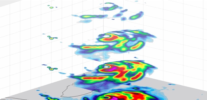
A new view of Hurricane Dorian shows the layers of the storm, as seen by an experimental NASA weather satellite that's the size of a cereal box. TEMPEST-D reveals rain bands in four layers of the storm as Hurricane Dorian approaches Florida on Sept. 3, 2019. The multiple vertical layers show where the strongest convective "storms" within the hurricane are pushing high into the atmosphere, with pink, red and yellow corresponding to the areas of heaviest rainfall.
Known as a CubeSat, TEMPEST-D (Temporal Experiment for Storms and Tropical Systems Demonstration) uses a miniaturized version of a microwave radiometer - a radio wave instrument used to measure rain and moisture within the clouds. If TEMPEST-D can successfully track storms like Dorian, the technology demonstration could lead to a train of small satellites that work together to track storms around the world. CubeSats are much less expensive to produce than traditional satellites; in multiples they could improve our global storm coverage and forecasting data.
TEMPEST-D is led by Colorado State University in Fort Collins and managed by JPL in partnership with Blue Canyon Technologies in Boulder, Colorado, and Wallops Flight Facility in Virginia. The mission is sponsored by NASA's Earth Ventures program and managed by the Earth Science Technology Office at NASA Headquarters in Washington. The radiometer instrument was built by JPL and employs high-frequency microwave amplifier technology developed by Northrop Grumman.