
13.06.2025
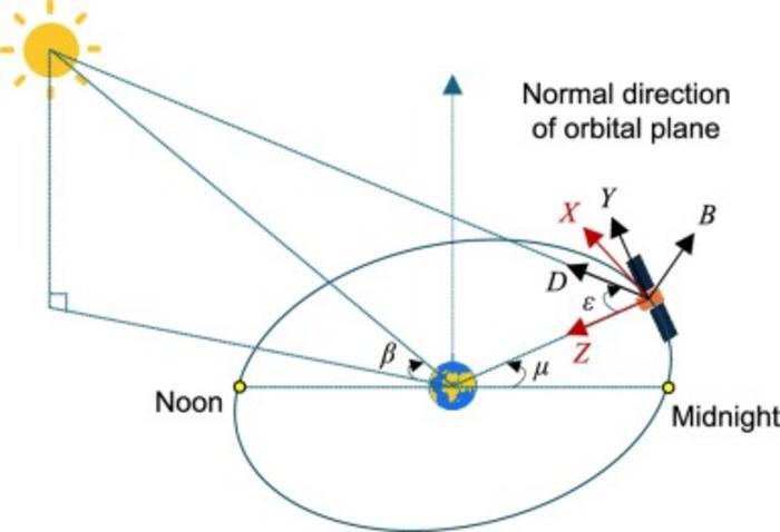
Demonstration of DYB (sun-oriented) frame, XYZ (body-fixed) orthogonal frame, the elevation angle of the Sun above the orbital plane β, orbital angle μ, and sun-elongation angle ε. (IMAGE)
Two BeiDou-3 satellites, once plagued by puzzling orbit errors, are now operating with newfound precision thanks to a breakthrough modeling strategy. Researchers discovered that standard models underestimated how solar radiation pressure (SRP) interacted with the satellites’ structure—especially those equipped with special rescue payloads. By integrating a physically informed Adjustable Box-Wing (ABW) model with the widely used extended Empirical CODE Orbit Model (ECOM2) method, they slashed laser ranging residual errors by over 60%. This hybrid strategy not only corrects the problem but also offers a flexible framework for improving orbit accuracy in real time—crucial for applications that rely on precise satellite positioning.
Since 2020, the BeiDou-3 system has become a global pillar of satellite navigation, offering precise services across a wide range of applications. However, the addition of Medium Earth Orbit Satellite-based Search and Rescue (MEOSAR) payloads to some of its satellites introduced unexpected orbit modeling challenges. These payloads disrupt satellite symmetry and affect how sunlight pushes against their surfaces—leading to inconsistent Satellite Laser Ranging (SLR) data, particularly for satellites C223 and C222. Previous empirical models, such as ECOM2, struggled to capture these subtle forces, leaving researchers with unexplained errors. Due to these challenges, more adaptive and physically grounded modeling approaches became necessary to ensure orbital reliability.
In a study (DOI: 10.1186/s43020-025-00166-9) published on June 2, 2025, in Satellite Navigation, a research team from Chang’an University unveiled a new approach to precise orbit modeling for BeiDou-3 satellites. The study focused on satellites C223 and C222, which had shown persistent laser tracking anomalies. By combining the Adjustable Box-Wing (ABW) model with the empirical ECOM2 approach, the team created a hybrid strategy that more accurately captures how solar radiation affects these complex satellite structures—resulting in significantly enhanced orbit predictions and real-time tracking reliability.
The team explored multiple modeling configurations, accounting for how the MEOSAR payload is mounted—either on the +X or −X side of the satellite. These structures cause self-shadowing effects that distort how sunlight applies force to the satellite body. Using these insights, researchers developed two ABW-based configurations (ABWX and ABWMX), which were tested alongside the ECOM2 model. While ECOM2 alone produced high residual errors and poor alignment with real SLR data, the ABW-enhanced models dramatically reduced residuals and improved stability.
To maintain both real-time applicability and model consistency, the team introduced four hybrid strategies (S1–S4), integrating ABW-derived solar force estimates into ECOM2's framework. These strategies not only reduced residual standard deviations from 7.8 cm to 3 cm but also improved daily orbit boundary continuity and 6–12 hour orbit prediction accuracy. Notably, the configuration assuming the payload is on the +X side yielded the most stable and accurate results. To further streamline implementation, the researchers also created deployable a priori SRP models based on Fourier-transformed ABW data, fixing the orbit errors without added orbit determination complexity. This flexible solution bridges the gap between physical realism and operational efficiency in satellite orbit modeling.
“This study resolves a long-standing problem in satellite orbit modeling,” said Prof. Guanwen Huang, corresponding author of the paper. “By identifying the root cause of the anomalies and developing a strategy that updates with each orbit arc, we’ve significantly enhanced the reliability of BeiDou-3. Our approach doesn’t just improve one or two satellites—it sets a precedent for how we model satellites with complex or asymmetric payloads going forward.”
The new strategy has far-reaching implications for satellite navigation and space-based Earth observation. By enabling more accurate real-time tracking of satellites with complex payloads, it enhances precision applications such as autonomous navigation, earthquake monitoring, and global positioning in remote areas. The orbit determination and a priori models developing strategies proposed in this work can also be adapted for future Global Navigation Satellite Systems (GNSS) missions, including Galileo or Global Positioning System (GPS) upgrades, where satellite structures are increasingly complex. For operators and agencies generating daily orbit products, this method offers a practical balance between physical accuracy and computational efficiency—paving the way for more resilient and adaptable space navigation systems.
Quelle: AAAS