
19.11.2019
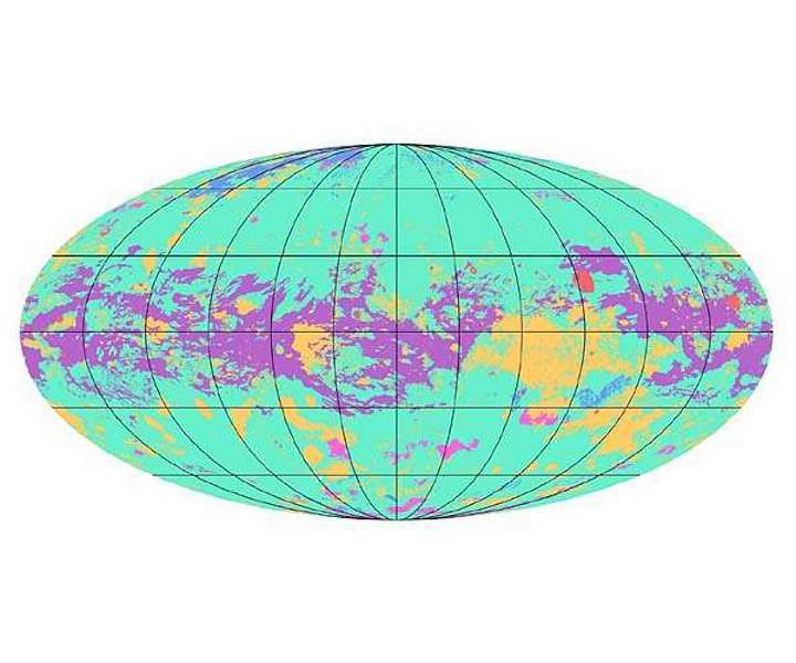
The first global geologic map of Saturn's largest moon, Titan, is based on radar and visible and infrared images from NASA's Cassini mission, which orbited Saturn from 2004 to 2017.
The first map showing the global geology of Saturn's largest moon, Titan, has been completed and fully reveals a dynamic world of dunes, lakes, plains, craters and other terrains.
Titan is the only planetary body in our solar system other than Earth known to have stable liquid on its surface. But instead of water raining down from clouds and filling lakes and seas as on Earth, on Titan what rains down is methane and ethane - hydrocarbons that we think of as gases but that behave as liquids in Titan's frigid climate.
"Titan has an active methane-based hydrologic cycle that has shaped a complex geologic landscape, making its surface one of most geologically diverse in the solar system," said Rosaly Lopes, a planetary geologist at NASA's Jet Propulsion Laboratory in Pasadena, California, and lead author of new research used to develop the map.
"Despite the different materials, temperatures and gravity fields between Earth and Titan, many surface features are similar between the two worlds and can be interpreted as being products of the same geologic processes. The map shows that the different geologic terrains have a clear distribution with latitude, globally, and that some terrains cover far more area than others."
Lopes and her team, including JPL's Michael Malaska, worked with fellow planetary geologist David Williams of the School of Earth and Space Exploration at Arizona State University in Tempe. Their findings, which include the relative age of Titan's geologic terrains, were recently published in the journal Nature Astronomy.
Lopes' team used data from NASA's Cassini mission, which operated between 2004 and 2017 and did more than 120 flybys of the Mercury-size moon. Specifically, they used data from Cassini's radar imager to penetrate Titan's opaque atmosphere of nitrogen and methane. In addition, the team used data from Cassini's visible and infrared instruments, which were able to capture some of Titan's larger geologic features through the methane haze.
"This study is an example of using combined datasets and instruments," Lopes said. "Although we did not have global coverage with synthetic aperture radar [SAR], we used data from other instruments and other modes from radar to correlate characteristics of the different terrain units so we could infer what the terrains are even in areas where we don't have SAR coverage."
Williams worked with the JPL team to identify what geologic units on Titan could be determined using first the radar images and then to extrapolate those units to the non-radar-covered regions. To do so, he built on his experience working with radar images on NASA's Magellan Venus orbiter and from a previous regional geologic map of Titan that he developed.
"The Cassini mission revealed that Titan is a geologically active world, where hydrocarbons like methane and ethane take the role that water has on Earth," Williams said. "These hydrocarbons rain down on the surface, flow in streams and rivers, accumulate in lakes and seas, and evaporate into the atmosphere. It's quite an astounding world!"
Quelle: SD
+++
First Global Geologic Map of Titan
The first global geologic map of Saturn's largest moon, Titan, is based on radar and visible and infrared images from NASA's Cassini mission, which orbited Saturn from 2004 to 2017.
Black lines mark 30 degrees of latitude and longitude. Map is in Mollweide projection, a global view that attempts to minimize the size or area distortion, especially at the poles (although shapes are increasingly distorted away from the center of the map). It is centered on 0 degrees latitude, 180 degrees longitude. Map scale is 1:20,000,000.
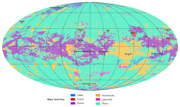
In the annotated figure, the map is labeled with several of the named surface features. Also located is the landing site of the European Space Agency's (ESA) Huygens Probe, part of NASA's Cassini mission.
The map legend colors represent the broad types of geologic units found on Titan: plains (broad, relatively flat regions), labyrinth (tectonically disrupted regions often containing fluvial channels), hummocky (hilly, with some mountains), dunes (mostly linear dunes, produced by winds in Titan's atmosphere), craters (formed by impacts) and lakes (regions now or previously filled with liquid methane or ethane). Titan is the only planetary body in our solar system other than Earth known to have stable liquid on its surface — methane and ethane.
The map was developed using Cassini radar data and Imaging Science Subsystem (ISS) images.
Quelle: NASA