
Almost three months after launching into space, the US National Oceanic and Atmospheric Administration’s (NOAA) latest weather satellite, called GOES-17, sent us its first official images of our planet. The incredible views, which were captured on May 20th and made public today, were taken even as the satellite is having some issues with one of its instruments.
GOES-17 went up to work with GOES-16, another NOAA weather satellite that was launched in 2016. The two probes, which are part of the so-called GOES-R series, are able to scan most of the Western Hemisphere from the coast of Africa all the way to New Zealand. Their observations from 22,300 miles (almost 36,000 kilometers) above Earth are key to monitor hurricanes, droughts, wildfires, lighting, and fog. The two spacecraft also provide us with stunning views of our planet.
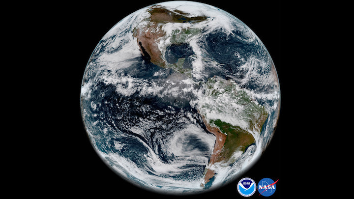
The latest snapshots of the Western Hemisphere were taken by a GOES-17 instrument called the Advanced Baseline Imager (ABI), which scans the planet in 16 spectral bands, including visible, infrared, and near-infrared channels. All these bands allow scientists to observe the movement and temperature of different types of clouds in greater depth than previous satellites, leading to better extreme weather forecasts.
The ABI on GOES-17, however, is having some issues. Its cooling system isn’t working properly. That’s a problem because the ABI’s infrared channel detectors “need to be cooled in order to fully sense the incoming infrared radiation from the Earth,” says Jordan Gerth, a research meteorologist at the Cooperative Institute for Meteorological Satellite Studies at the University of Wisconsin, in an email to The Verge. The infrared radiation is needed to detect clouds during the night when the sunlight isn’t reflecting off the clouds and back into space. But if the ABI’s detectors heat up, “there is a significant degradation in the quality of the imagery,” Gerth says.
Experts at NOAA and NASA, as well as others in the industry, are trying to solve the issue, which affects 13 of the spectral bands. Today’s photos show that, despite the problem with the cooling system, the ABI can snap amazing views of the Western Hemisphere. The images were captured using two visible and one near-infrared channel that are not affected by the cooling system malfunction. One infrared band included in the photos is only “functional during a portion of the day,” NOAA said in a press release.
Gerth says that other test images were snapped by GOES-17, “but they were taken before the necessary calibration could occur. Some images also did not have the full disk illuminated.”
The satellite is still in its testing phase and won’t become fully operational until late 2018. If the cooling system can’t be fixed, the team will be “looking at alternative concepts and different modes to maximize the operational utility of this ABI,” Stephen Volz, assistant administrator for NOAA’s Satellite and Information Services said during a press briefing last week.
In the meantime, hopefully we’ll get more photos of planet Earth in all its glory.
Quelle: THE VERGE