
-
-
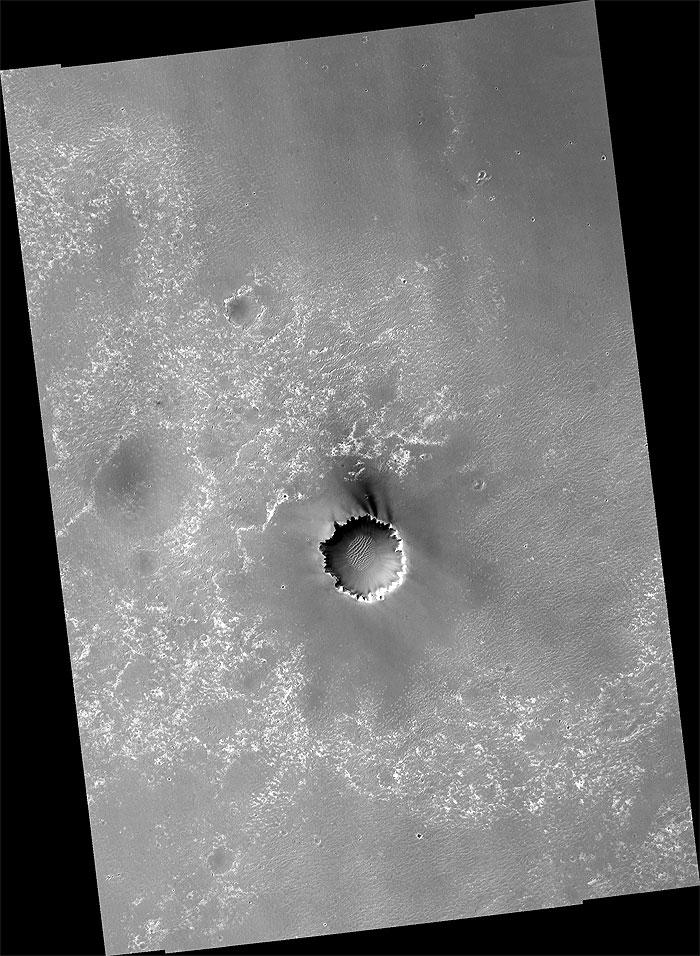
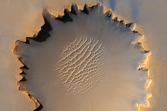
This HiRISE image shows "Victoria Crater," an impact crater at Meridiani Planum, near the equator of Mars. The crater is approximately 800 meters (about half a mile) in diameter. It has a distinctive "scalloped" shape to its rim, caused by erosion and downhill movement of crater wall material. Layered sedimentary rocks are exposed along the inner wall of the crater, and boulders that have fallen from the crater wall are visible on the crater floor. The floor of the crater is occupied by a striking field of sand dunes.
Since January, 2004, the Mars Exploration Rover Opportunity has been operating at Meridiani Planum. Five days before this image was taken, Opportunity arrived at the rim of Victoria Crater, after a drive of more than 9 km (over 5 miles). The rover can be seen in this image, at roughly the "ten o'clock" position along the rim of the crater.
-
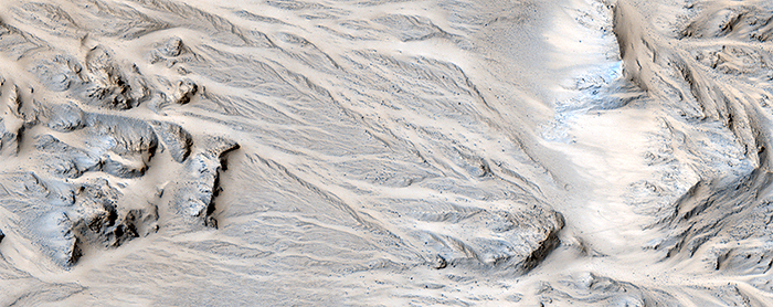
Aptly-named Mojave Crater in the Xanthe Terra region has alluvial fans that look remarkably similar to landforms in the Mojave Desert of southeastern California and portions of Nevada and Arizona.
Alluvial fans are fan-shaped deposits of water-transported material (alluvium). They typically form at the base of hills or mountains where there is a marked break, or flattening of slope.
They typically deposit big rocks near their mouths (close to the mountains) and smaller rocks at greater distances. Alluvial fans form as a result of heavy desert downpours, typically thundershowers. Because deserts are poorly vegetated, heavy and short-lived downpours create a great deal of erosion and nearby deposition.
There are fans inside and around the outsides of Mojave crater on Mars that perfectly match the morphology of alluvial fans on Earth, with the exception of a few small impact craters dotting this Martian landscape.
Channels begin at the apex of topographic ridges, consistent with precipitation as the source of water, rather than groundwater. This remarkable landscape was first discovered from Mars Orbital Camera images. Mars researchers have suggested that impact-induced atmospheric precipitation may have created these unique landscapes.
This HiRISE image at up to 29 cm/pixel scale supports the alluvial fan interpretation, in particular by showing that the sizes of the largest rocks decrease away from the mouths of the fans.
-
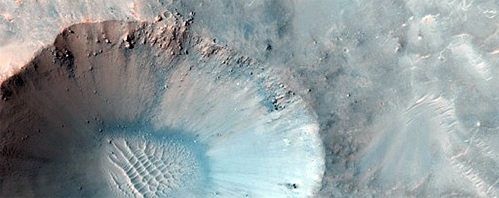
Most debris on crater walls slides straight downhill. In this HiRISE image we see examples of boulders that have bounced downhill, not necessarily vertically.
A prominent example looks like a dotted line from the top of the crater wall where the boulder took off to the crater floor where it finally came to rest.
Numerous boulders have slid partway down toward the crater floor, which is covered by sand dunes. This is actually a small crater (approximately 1 kilometer wide) within an unnamed but much larger approximately 30 kilometer crater.
-
This image shows dunes on the northern plains of Mars, and appears similar to images taken when the surface was covered by frost.
However, CRISM spectra taken at the same time do not show evidence for either water or carbon dioxide frost here. Possibly, and consistent with the CRISM spectra, this area is covered by dust, obscuring the dark material that is typically present in dunes of this type.
The orientation of the dunes indicates that they were formed by winds blowing generally from upper right to lower left. Ripples on the dunes show that the wind patterns that formed them are more complex, with the dune shapes affecting the wind direction.
It is not known whether these dunes are currently active (being moved by wind today) or have been in this location for a very long time, but if they are indeed covered by dust they cannot have been recently active.
Between the dunes, the underlying surface of the northern plains can be seen. In places, it has been fractured into polygonal blocks, suggesting that water ice is or was present below the surface. Meter-size blocks are also seen in places in this image and elsewhere on the northern plains. The origin of these blocks is not known, but they may be remnants of erosion of material that once covered this region.
-
This image shows a stack of layers on the floor of an impact crater roughly 30 kilometers across. Many of the layers appear to be extremely thin, and barely resolved.
In broad view, it is clear that the deposit is eroding into a series of ridges, likely due to the wind. Below the ridges, additional dark-toned layered deposits crop out. These exhibit a variety of textures, some of which may be due to transport of material.
The light ridges are often capped by thin dark layers, and similar layers are exposed on the flanks of the ridges. These layers are likely harder than the rest of the material, and so armor the surface against erosion. They are shedding boulders which roll down the slope, as shown in the subimage. Although these cap layers are relatively resistant, the boulders do not seem to accumulate at the base of the slope, so it is likely that they also disintegrate relatively quickly.
The subimage itself is 250 meters wide. The light is from the left. Boulders are visible on the slopes of the ridges along with thin dark layers including the cap layer, but they are absent on the spurs where the resistant cover has been eroded. This demonstrates that the boulders come only from the dark layers, and are not embedded in the rest of the deposit.
-
This observation shows a portion of the central sedimentary deposits in Pasteur Crater.
The deposits in this image are eroding into knobs and ridges. The erosion is probably dominated by wind, as most of the ridges are parallel. This is common in wind-eroded features, with the ridges generally aligned with the prevailing wind.
At high resolution, layering is revealed in many of the knobs and outcrops. The horizontal layers indicate that the material was deposited uniformly over a broad area. Possible origins include volcanic airfall or lacustrine (lake) deposits. After deposition, the rock in this area has been fractured and faulted, forming a diverse array of cracks.
The mottled appearance of much of the image is caused by dark, featureless patches which may be wind-blown dust. These have interacted with lighter-toned ridges and ripples which are probably also formed by aeolian (wind) processes. In places, the dark patches partially cover the ripples, indicating that they have moved more recently, but they must be thin because the ripples frequently stand above surrounding dark material.
The ripples exhibit multiple interacting orientations in some places, producing networks of small ridges which reflect movement in winds from several directions.
-
Quelle: NASA
6664 Views