
10.03.2023
The sand dunes were imaged as part of a program to see how frost melts on the Red Planet in late winter.
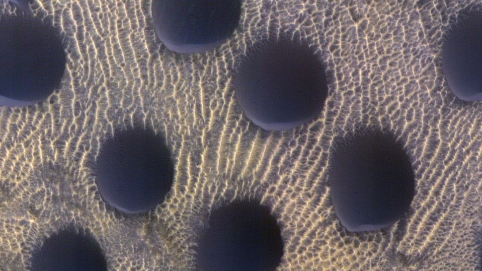
An image of almost perfectly circular sand dunes on Mars taken by the HiRISE camera. (Image credit: NASA/JPL-Caltech/UArizona)
Planetary scientists have captured an image of near-perfectly circular sand dunes on the surface of Mars. While sand dunes across the Red Planet come in a wealth of shapes and sizes, such well-defined circles are unusual.
The slight asymmetry in the sand dunes shows their steep sides are orientated towards the south. The University of Arizona, which operates the High-Resolution Imaging Experiment (HiRise) camera used to take the image, pointed out in a statement(opens in new tab) that this indicates sands are blown southwards, though the Martian winds may be variable.
The image was taken on November 22, 2022, at a latitude of 42.505 degrees and a longitude of 67.076 degrees. It comes as part of a series of pictures taken by the HiRise camera that orbits Mars on the Mars Reconnaissance Orbiter (MRO) spacecraft.
The collection of images is being used to monitor how frost recedes and melts on the Martian surface as the Red Planet reaches the end of its winter season. Illustrating this, while this image appears frost-free a similar image of the same sand dunes previously taken shows what they looked like while still covered in frost.
The sand dune image was taken while the MRO was at an altitude of around 185 miles (300 kilometers) over the Martian surface. Each pixel in the image represents 25 centimeters (9.8 inches).
This is just one of 60 sites on Mars being monitored by HiRise. The high-resolution camera has been orbiting the Red Planet since the MRO reached Mars in 2006 and began conducting the first dedicated survey of the planet's sand dunes.
Collecting repeated observations of sand dunes over the Martian year (lasting 687 Earth days) has allowed planetary scientists to monitor how fast the dunes move. This has revealed that sand dunes from the equator to the poles are advancing at rates of up to 3.3 feet (1 meter) per Martian year.
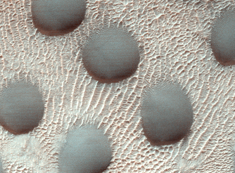
Circular sand dunes on the surface of Mars covered in frost. (Image credit: NASA/JPL-Caltech/UArizona)
The camera has recorded a variety of Martian sand dunes with an impressive range of both sizes and shapes, revealing a great deal about weather conditions on the Red Planet. For example, while examining the Lyot Crater in the northern lowlands of Mars in 2010, HiRise imaged dune fields that indicated how local winds are channeled through the topology of this 146-mile-wide (236-kilometer) complex impact crater.
HiRise is also conducting ongoing research that looks at glacier-like formations across Mars and examines the crevasse-type fractures that punctuate their surfaces. By collecting repeated observations over time, the images can help scientists determine the kind of fracture mechanics that occur in so-called "viscous flow features" found at the bases of slopes on Mars. These deposits are believed to have once been rich in ice, but the source of this ice is thus far a mystery, according to NASA.(opens in new tab)
On December 21, 2010, the primary mission of the MRO ended five years and six months after its launch on August 12, 2005. This new image shows that even 12 years after the end of that mission the contribution to science made by the spacecraft and its HiRise camera is far from over.
Quelle: SC