
5.02.2023
NASA-ISRO Earth Science Instruments Get Send-Off Before Moving to India
Dignitaries from the U.S. and Indian space agencies, along with members of the media, were invited to see NISAR’s science payload in a Jet Propulsion Laboratory clean room.
It’s nearly time for the scientific heart of NISAR – short for NASA-ISRO Synthetic Aperture Radar – an Earth science satellite being jointly built by NASA and the Indian Space Research Organisation, to ship out to its last stop before launching into orbit: southern India. Before its departure, members of the media got a chance to see NISAR’s advanced radar instruments up close on Feb. 3 in a clean room at NASA’s Jet Propulsion Laboratory (JPL) in Southern California. Journalists spoke with ISRO Chairman S. Somanath, JPL Director Laurie Leshin, dignitaries from NASA headquarters and India, and members of the mission team.
“This marks an important milestone in our shared journey to better understand planet Earth and our changing climate,” Leshin said. “NISAR will provide critical information on Earth’s crust, ice sheets, and ecosystems. By delivering measurements at unprecedented precision, NISAR’s promise is new understanding and positive impact in communities. Our collaboration with ISRO exemplifies what’s possible when we tackle complex challenges together.”
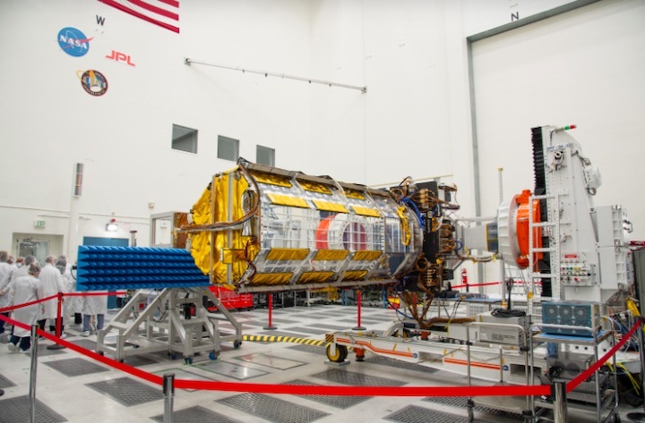
Somanath, Indian Ambassador and Deputy Chief of Mission Sripriya Ranganathan, and NASA officials toured the High Bay 2 clean room, where they saw engineers and technicians putting the science instrument payload through final electrical testing.
Outside the facility, in front of a scale model of the NISAR satellite, NASA’s NISAR Project Manager Phil Barela and ISRO’s NISAR Project Director CV Shrikant ceremonially broke fresh coconuts. The tradition, common in India, often marks auspicious occasions and signifies hope for a smooth road ahead. Leshin also presented the ISRO delegation with a jar of JPL lucky peanuts.
Also present were Bhavya Lal, NASA’s associate administrator for technology, policy, and strategy; Karen St. Germain, director of NASA’s Earth Science Division; and Gerald Bawden, NISAR program scientist, among others.
“Today we come one step closer to fulfilling the immense scientific potential NASA and ISRO envisioned for NISAR when we joined forces more than eight years ago,” Somanath said. “This mission will be a powerful demonstration of the capability of radar as a science tool and help us study Earth’s dynamic land and ice surfaces in greater detail than ever before.”
Members of the media also visited the clean room, speaking with key figures on the NASA mission team, including Deputy Project Manager Wendy Edelstein and Deputy Project Scientist Susan Owen.
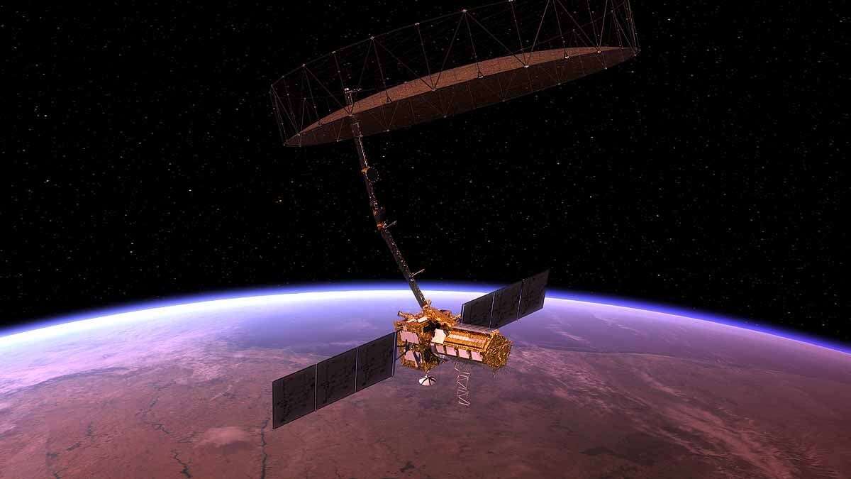
NISAR will gather radar data with a drum-shaped reflector antenna almost 40 feet (12 meters) in diameter. It will use a signal-processing technique called interferometric synthetic aperture radar, or InSAR, to observe changes in Earth’s land and ice surfaces down to fractions of an inch.
Since early 2021, engineers and technicians at JPL have been integrating and testing NISAR’s two radar systems – the L-band SAR provided by JPL and the S-band SAR built by ISRO. Later this month, they will move the SUV-size payload into a special cargo container for a 9,000-mile (14,000-kilometer) flight to India’s U R Rao Satellite Centre in the city of Bengaluru. There it will be merged with the spacecraft bus in preparation for a 2024 launch from Satish Dhawan Space Centre in Andhra Pradesh state.
The observations NISAR makes will help researchers measure the ways in which Earth is constantly changing by detecting both subtle and dramatic movements. Slow-moving variations of a land surface can precede earthquakes, landslides, and volcanic eruptions, and data about such movement could help communities prepare for natural hazards. Measurements of melting sea ice and ice sheets will improve understanding of the pace and impacts of climate change, including sea level rise. And observations of the planet’s forest and agricultural regions will improve our knowledge of carbon exchange between the atmosphere and plant communities, reducing uncertainties in models used to project future climate.
Over the course of its three-year prime mission, the satellite will observe nearly the entire planet every 12 days, making observations day and night, in all weather conditions.
“We have only just begun to envision the new knowledge and tangible benefits NISAR observations will have for communities around the world,” St. Germain said. “This moment is the culmination of years of cooperation between NASA and ISRO and shows our shared commitment to advancing science and benefitting humanity.”
More About the Mission
NISAR is a joint Earth-observing mission between NASA and ISRO. JPL, which is managed for NASA by Caltech in Pasadena, leads the U.S. component of the project and is providing the mission’s L-band SAR. NASA is also providing the radar reflector antenna, the deployable boom, a high-rate communication subsystem for science data, GPS receivers, a solid-state recorder, and payload data subsystem. ISRO is providing the spacecraft bus, the S-band SAR, the launch vehicle, and associated launch services and satellite mission operations.
Quelle: NASA
----
Update: 10.03.2023
.
NISAR payload arrives for final integration in BengaluruThe payload was moved to the U R Rao Satellite Centre in Bengaluru to carry out further testing and assembly, Isro said on Wednesday
The integrated payload of NISAR (NASA-ISRO Synthetic Aperture Radar), the low earth orbit observatory jointly developed by NASA and the Indian Space Research Organisation (Isro), reached Bengaluru in the early hours of Monday. The payload was moved to the U R Rao Satellite Centre in Bengaluru to carry out further testing and assembly, Isro said on Wednesday.
NISAR comes with capabilities to map the earth and track changes in its ecosystems, including sea levels and conditions that lead up to natural hazards like earthquakes and landslides. The low earth orbit observatory is expected to be launched in January 2024. It will use two frequencies — through Isro’s S-band radar and NASA’s L-band radar — and employ the Sweep SAR technique to produce high-resolution data. The send-off ceremony of the science instrument payload of NISAR was held at NASA’s Jet Propulsion Laboratory (JPL) in California on February 3. Engineers and technicians at JPL have been integrating and testing the two radar systems since early 2021. The US Consulate General Chennai said Isro receiving the payload — that arrived on a US Air Force C-17 aircraft — set the stage for the final integration of the satellite, a “true symbol” of civil space collaboration between India and the US.
Quelle:DeccanHerald
----
Update: 15.07.2023
.
Powerful NASA-ISRO Earth Observing Satellite Coming Together in India
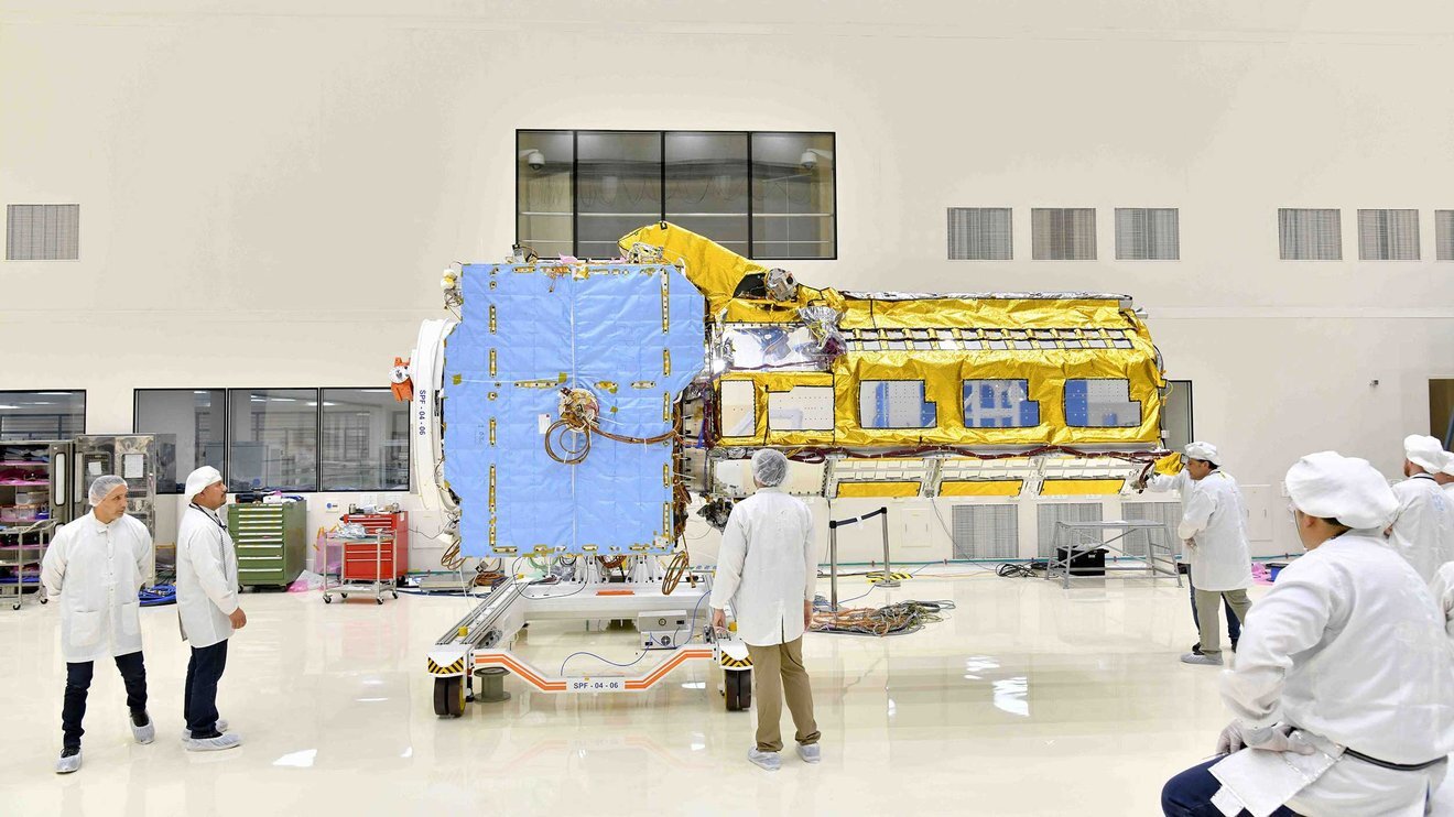
Engineers joined the two main components of NISAR – the spacecraft bus and the radar instrument payload – in an ISRO clean room in Bengaluru, India, in June. The payload arrived from NASA’s Jet Propulsion Laboratory in Southern California in March, while the bus was built at the ISRO facility.
Credit: Credit: VDOS-URSC
Built on opposite sides of the planet, the NISAR satellite will deepen understanding of climate change, deforestation, glacier melt, volcanoes, earthquakes, and more.
Two major components of the NISAR satellite have been combined to create a single spacecraft in Bengaluru, India. Set to launch in early 2024, NISAR – short for NASA-ISRO Synthetic Aperture Radar – is being jointly developed by NASA and the Indian Space Research Organisation, or ISRO, to track movements of Earth’s land and ice surfaces in extremely fine detail. As NISAR monitors nearly every part of our planet at least once every 12 days, the satellite will also help scientists understand, among other observables, the dynamics of forests, wetlands, and agricultural lands.

A crane is used to align NISAR’s radar instrument payload, seen partially wrapped in gold-colored thermal blanketing, with the satellite’s spacecraft bus, which is inside blue blanketing, in an ISRO clean room in Bengaluru, India, in June.
About the size of an SUV and partially wrapped in gold-colored thermal blanketing, the satellite’s cylindrical radar instrument payload contains two radar systems. The S-band radar is particularly useful for monitoring crop structure and the roughness of land and ice surfaces, while the L-band instrument can penetrate denser forest canopies to study the woody trunks of trees, among other observables. The wavelengths of the S-band and L-band signals are about 4 inches (10 centimeters) and 10 inches (25 centimeters), respectively, and both sensors can see through clouds and collect data day and night.
The payload took a roundabout journey to get to this point. The S-band radar was built at the Space Applications Centre in Ahmedabad in western India, then flown in March 2021 to NASA’s Jet Propulsion Laboratory in Southern California, where engineers had been developing NISAR’s L-band radar. At JPL, the two systems were fixed to the payload’s barrel-like frame before being flown to the U R Rao Satellite Centre (URSC) in the southern Indian city of Bengaluru in March 2023.
In the meantime, engineers and technicians at URSC, collaborating with teams from JPL, were busy developing the spacecraft’s main body, or bus, which is covered in blue blanketing that protects it during assembly and testing prior to launch. The bus, which includes components and systems developed by both ISRO and JPL, will provide power, navigation, pointing control, and communications for the mission.
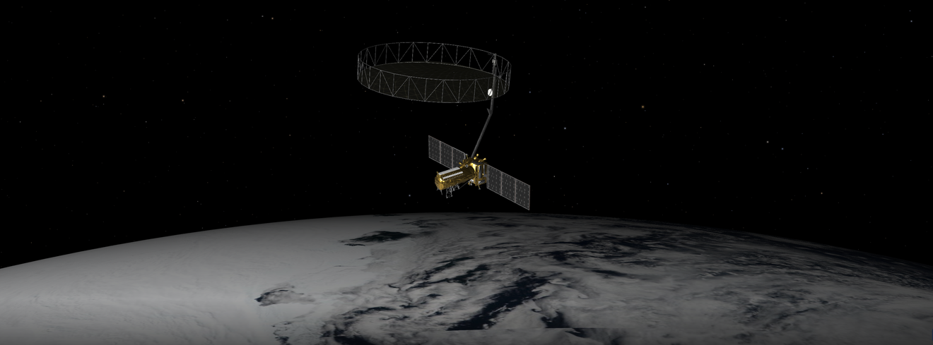
Since the radar payload and bus were joined in a URSC clean room in mid-June, NASA and ISRO teams have been working together to route thousands of feet of cabling between them. Still to be attached: the satellite’s solar panels, as well as the drum-shaped, wire-mesh reflector that will unfold from the end of a 30-foot (9-meter) boom. At nearly 40 feet (12 meters) in diameter, the reflector will be largest radar antenna of its kind ever launched into space.
The NISAR satellite is currently undergoing performance testing, to be followed by several rounds of environmental testing to ensure it can withstand the rigors of launch and meet all of its operational requirements once in orbit. Then it will be transported about 220 miles (350 kilometers) eastward to Satish Dhawan Space Centre, where it will be inserted into its launch fairing, mounted atop ISRO’s Geosynchronous Satellite Launch Vehicle Mark II rocket, and sent into low Earth orbit.
More About the Mission
NISAR is an equal collaboration between NASA and ISRO and marks the first time the two agencies have cooperated on hardware development for an Earth-observing mission. JPL, which is managed for NASA by Caltech in Pasadena, leads the U.S. component of the project and is providing the mission’s L-band SAR. NASA is also providing the radar reflector antenna, the deployable boom, a high-rate communication subsystem for science data, GPS receivers, a solid-state recorder, and payload data subsystem. URSC, which is leading the ISRO component of the mission, is providing the spacecraft bus, the S-band SAR electronics, the launch vehicle, and associated launch services and satellite mission operations.
Quelle: NASA
----
Update: 15.11.2023
.
NISAR Completes Trial in ISRO's Compact Antenna Test Facility
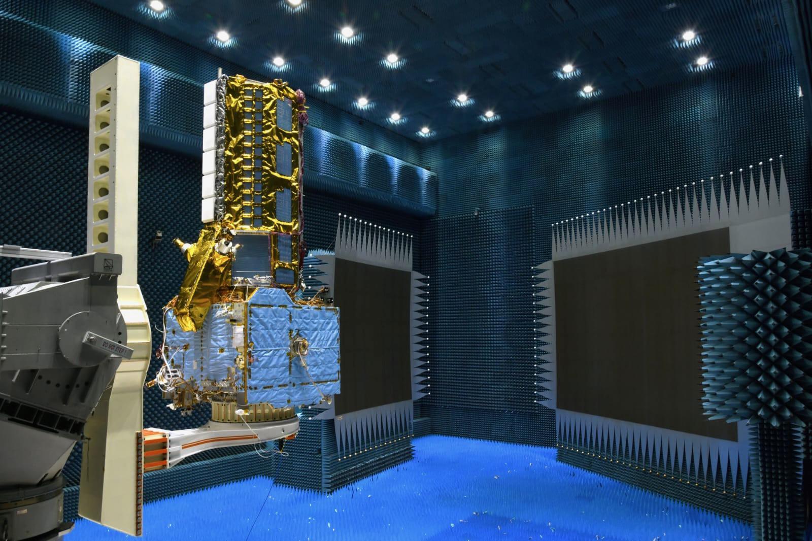
The NISAR satellite, partially covered in gold-hued thermal blanketing, is seen at the Indian Space Research Organisation's compact antenna test facility in Bengaluru, India, in September 2023.
Short for NASA-ISRO Synthetic Aperture Radar, NISAR completed 20 days of testing in the chamber, where engineers found that the radio signals from the two radar systems' antennas passed requirements. The blue foam spikes lining the walls, floor, and ceiling prevent radio waves from bouncing around the room and interfering with measurement. The test was followed by a 21-day trial in a thermal vacuum chamber that showed the spacecraft can function in the extreme temperatures and the vacuum of space.
After further tests, the satellite will be transported about 220 miles (350 kilometers) eastward to Satish Dhawan Space Centre, where it will be inserted into its launch faring, mounted atop ISRO's Geosynchronous Satellite Launch Vehicle Mark II rocket, and sent into low-Earth orbit.
NISAR is the first space-hardware collaboration between NASA and ISRO on an Earth-observing mission. Scheduled to launch in early 2024, the satellite will scan nearly all of the planet's land and ice twice every 12 days, monitoring the motion of those surfaces down to fractions of an inch. It will also track other processes, including the dynamics of forests, wetlands, and agricultural lands.
JPL, which is managed for NASA by Caltech in Pasadena, leads the U.S. component of the project.
Quelle: NASA
----
Update: 12.01.2024
.
This US-Indian Satellite Will Monitor Earth’s Changing Frozen Regions
NISAR will study changes to ice sheets, glaciers, and sea ice in fine detail, as climate change warms the air and ocean.
NISAR, the soon-to-launch radar satellite from NASA and the Indian Space Research Organisation (ISRO), will measure some key Earth vital signs, from the health of wetlands to ground deformation by volcanoes to the dynamics of land and sea ice.
This last capability will help researchers decipher how small-scale processes can cause monumental changes in the ice sheets covering Antarctica and Greenland, as well as on mountain glaciers and sea ice around the world.
Short for NASA-ISRO Synthetic Aperture Radar, NISAR will provide the most comprehensive picture to date of motion and deformation of frozen surfaces in Earth’s ice- and snow-covered environments, collectively known as the cryosphere.
“Our planet has the thermostat set on high, and Earth’s ice is responding by speeding up its motion and melting faster,” said Alex Gardner, a glaciologist at NASA’s Jet Propulsion Laboratory in Southern California. “We need to better understand the processes at play, and NISAR will provide measurements to do that.”
Set to be launched in 2024 by ISRO from southern India, NISAR will observe nearly all the planet’s land and ice surfaces twice every 12 days. The satellite’s unique insights into Earth’s cryosphere will come from the combined use of two radars: an L-band system with a 10-inch (25-centimeter) wavelength and an S-band system with a 4-inch (10-centimeter) wavelength.
L-band can see through snow, helping scientists better track the motion of ice underneath, while S-band is more sensitive to snow moisture, which indicates melting. Both signals penetrate clouds and darkness, enabling observations during monthslong polar winter nights.
‘Time-Lapse Movie’ of Ice Sheets
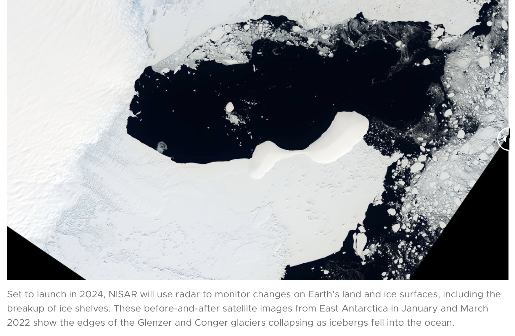
NISAR’s orientation in orbit will enable it to collect data from Antarctica’s far interior, close to the South Pole – unlike other large imaging radar satellites, which have more extensively covered the Arctic.
Antarctica’s ice sheets hold the planet’s largest reservoir of frozen fresh water, and the rate at which it may lose ice represents the greatest uncertainty in sea level rise projections. NISAR’s increased coverage will be crucial for studying the motion of ice flowing down from central Antarctica’s high elevations toward the sea.
The measurements will also enable scientists to closely study what happens where ice and ocean meet. For example, when parts of an ice sheet sit on ground that is below sea level, saltwater can seep under the ice and increase melting and instability. Both Antarctica and Greenland also have ice shelves – masses of ice that extend from land and float on the ocean – that are thinning and crumbling as icebergs break off. Ice shelves help keep glacial ice on the land from slipping into the ocean. If they are diminished, glaciers can flow and calve faster.
Ice losses on both Antarctica and Greenland have accelerated since the 1990s, and there’s uncertainty about how quickly each will continue to recede. NISAR will improve our horizontal and vertical views of these changes.
“NISAR will give us a consistent time-lapse movie of that motion, so we can understand how and why it’s changing and better predict how it will change into the future,” said Ian Joughin, a glaciologist at the University of Washington in Seattle and the NISAR cryosphere lead.
Mountain Glaciers, Water Supply, and Flooding
The satellite will also track changes in Earth’s mountain glaciers. Their melting has contributed about a third of the sea level rise seen since the 1960s, and climate-driven changes to freezing and thawing patterns can affect the water supplies of downstream populations.
In the Himalayas, NISAR’s all-weather capability will help researchers monitor how much water is stored in glacial lakes, which is essential to assessing the risk of catastrophic floods.
“The beauty and the difficulty of the Himalayas are the clouds,” said Sushil Kumar Singh, a glaciologist at the ISRO Space Applications Centre in Ahmedabad, India. “With NISAR we will be able to get a more continuous and complete data set that would not be possible with instruments that use visible light.”
Sea Ice Dynamics Near Both Poles
NISAR will also capture the movement and extent of sea ice in both hemispheres. Sea ice insulates the ocean from the air, reducing evaporation and heat loss to the atmosphere. It also reflects sunlight, keeping the planet cool through the albedo effect.
Arctic sea ice has been diminishing for decades as rising water and air temperatures have increased melting. With more of its surface exposed to sunlight, the Arctic Ocean gains and holds more heat in summer and takes longer to cool. This means less ice formation in winter and faster melting the next summer, said Ben Holt, a JPL sea-ice scientist.
With greater coverage of the Southern Ocean than any radar mission to date, NISAR will open new insights around Antarctica, where sea ice had mostly been more stable until the past few years. It reached a record low in 2023.
More About the Mission
NISAR is an equal collaboration between NASA and ISRO and marks the first time the two agencies have cooperated on hardware development for an Earth-observing mission. NASA’s Jet Propulsion Laboratory, which is managed for the agency by Caltech in Pasadena, California, leads the U.S. component of the project and is providing the mission’s L-band SAR. NASA is also providing the radar reflector antenna, the deployable boom, a high-rate communication subsystem for science data, GPS receivers, a solid-state recorder, and payload data subsystem. U R Rao Satellite Centre (URSC) in Bengaluru, which leads the ISRO component of the mission, is providing the spacecraft bus, the launch vehicle, and associated launch services and satellite mission operations. ISRO’s Space Applications Centre in Ahmedabad is providing the S-band SAR electronics.
Quelle: NASA
----
Update: 8.03.2024
.
NASA and ISRO set to launch NISAR Satellite, aiming to revolutionize Earth observation
BENGALURU: When you see a piece of technology being produced and realise that this is going to go to space, it is mind-boggling, said Nicola Fox, Associate Administrator (AA), NASA Science Mission Directorate (SMD). She was speaking about the jointly developed satellite by NASA and the Indian Space Research Organisation (ISRO)-- NISAR (NASA–ISRO Synthetic Aperture Radar) which according to sources is expected to be launched at the end of March or early April.
Fox will soon be visiting the ISRO facility to take a closer look at the satellite and meet the team to understand more about how the dual frequency band will measure the Earth’s changing ecosystem.
The NASA administrator was speaking a the ‘Space Talk with NASA Women Scientists’ organised by the US Consulate General Chennai and Maharani Lakshmi Ammanni College for Women Autonomous (mLAC) in the city. “This is a very clever technique using the L band and S band, and I am very excited about this flagship event which will measure the changes in our planet’s surface just about at a centimeter’s scale.”
She added that the partnership with ISRO is very beneficial as the agency uses complementary science and has real-world applications of the data produced.
Highlighting the need for robust computational power and the demand for new applications, Fox said that the rate at which data is being generated is very difficult for “humans to look through” and would need artificial intelligence. “If we are generating 100 terabytes of dat right now through the Earth observation satellite, with NISAR’s launch it will double down.”
Fox also spoke about NASA’s plans and emphasised that at any point the space agency is working on 140 different missions–some of which are being designed while many have already taken flight. Speaking about the recently launched PACE Mission (Plankton, Aerosol, Cloud, ocean Ecosystem) she said that data will be released later this year.
“If you ever wondered how beautiful our planet is, wait till you see this data from PACE which will be mindblowing. It looks at two aspects, the health of our oceans–planktons and aerosols which are suspended in the clouds and fuel phytoplankton growth,” Fox said while addressing students.
The administrator also revealed that to increase the adaptability of a human body in space – zero gravity area and radiation, the biological and physical science department is working on making food more sustainable “more hardy and rugged.” A metal 3D printer was recently sent to the space centre.
“In the space of medical experiments, NASA is replicating human organs on chips with the help of tissues to test them in zero gravity and find different medical interventions.”
Antenna work delays NISAR launch
The addition of a reflective coating on the spacecraft's large deployable antenna will delay the launch of NISAR, likely to the second half of the year. Credit: NASA
WASHINGTON — Modifications to a large deployable antenna on a joint U.S.-Indian radar spacecraft will delay its launch, likely to the second half of the year.
In a March 22 statement, NASA said a new launch date for the NASA-ISRO Synthetic Aperture Radar (NISAR) mission will be set at the end of April because of work to protect the spacecraft’s reflector, an antenna that is 12 meters across when fully deployed, from temperatures when in its stowed configuration.
“Testing and analysis identified a potential for the reflector to experience higher-than-previously-anticipated temperatures in its stowed configuration in flight,” NASA said in the statement. To prevent those increased temperatures, a “special coating” will be applied to the antenna so that it reflects more sunlight.
That work, NASA said, requires shipping the antenna, currently with the rest of the NISAR spacecraft in India, to a facility in California that can apply the coating. NASA did not state how long the process of applying the coating, as well as shipping the antenna to California and then back to India, will take.
NASA officials had previously stated they expected a launch of NISAR in the spring. During a town hall about the mission at the Fall Meeting of the American Geophysical Union in December, project officials projected the mission to launch at the end of March.
In a recent interview with the Times of India, S. Somanath, chairman of the Indian space agency ISRO, said that the launch of NISAR would be delayed from the first quarter of the year, but offered few details about why other than it was not linked to the Geosynchronous Satellite Launch Vehicle (GSLV) Mark 2 rocket that will launch it.
“NISAR is still undergoing testing. It looks like the satellite may be delayed,” he said. Asked when the launch would take place, he said the “second half” of the year.
NISAR is the first Earth science spacecraft collaboration between NASA and ISRO and represents one of the biggest partnerships between the agencies in general, with NASA alone spending more than $1 billion in formulation and development of the mission. NASA is providing an L-band radar and engineering payload, while ISRO is providing the S-band payload, spacecraft bus and launch vehicle.
The radars on NISAR will be capable of advanced radar imaging to support a wide range of Earth science needs, from measuring the flow rates of glaciers to volcanic activity. The spacecraft will be able to map the entire Earth every 12 days.
Development of what would become NISAR started in response to recommendations from an Earth science decadal survey in 2007, but the mission is now playing a key role in NASA’s implementation of the latest Earth science decadal survey in 2018. That study recommended pursuing five “designated observables” with various missions, including one for surface deformation and change, or SDC, that would include a radar imaging payload.
NASA had been studying concepts for SDC as part of its overall Earth System Observatory, a suite of missions to implement those designated observables, but had planned to delay any development of that mission in order to incorporate lessons learned from NISAR. However, as part of a restructuring of the Earth System Observatory announced as part of the fiscal year 2025 budget request released March 11, NASA will no longer develop an SDC mission, instead using data from NISAR to fulfill that designated observable.
“We knew if that mission kicked off, it would be towards the end of the decadal period,” Karen St. Germain, director of NASA’s Earth science division, said of SDC during a March 20 presentation at a meeting of the National Academies’ Committee on Earth Science and Applications in Space.
“Given that we are going to be launching NISAR later this year and we want to learn from NISAR, we terminated that study” for SDC, she said, “with the idea being that, in the next decadal, we would determine if we want to restart an effort along those lines.”
Quelle: SN
----
Update: 31.07.2024
.
NASA-ISRO Satellite Mission NISAR Not Happening In 2024, New Timeline Revealed
The joint NASA-ISRO mission to launch an Earth-observation satellite is no longer happening this year. The NASA-ISRO Synthetic Aperture Radar (NISAR) is now targeted for launch no earlier than February 2025 after the additional work on the satellite is complete, SpaceNews reported.
The confirmation comes after Union Minister of State for Science and Technology, in a reply to a Lok Sabha query, listed missions to be launched by ISRO this year. The list excluded NISAR.
The satellite currently requires proper coating on the drum shaped radar antenna reflector which has been contributed by NASA. The component was shipped back to California, US after engineers found that it could face higher than expected temperatures during its stowed configuration during launch.

In a blog post, NASA said that a "reflective tape was applied and other precautionary measures were taken to mitigate temperature increases that could have potentially affected the deployment of the reflector."
It further explained that the launch is not possible between early October 2024 and early February 2025, because that launch window would put the satellite into periods of alternating sunlight and shadows due to the Sun's position. It further said that "the resulting temperature fluctuations could affect the deployment of NISAR’s boom and radar antenna reflector."
NISAR has been designed to map the planet every 12 days to gather data on changes in Earth’s ecosystems, ice mass, vegetation biomass, sea level rise, ground water and natural hazards including earthquakes, tsunamis, volcanoes and landslides.
Later this year, the reflector will be shipped again to Bengaluru for its integration with NISAR before it could be launched. The lift off will take place on ISRO's heaviest rocket LVM3 from the Satish Dhawan Space Centre in Sriharikota.
Quelle: Mashable India
----
Update: 23.10.2024
.


Quelle: The Times of India
----
Update: 8.01.2025
.
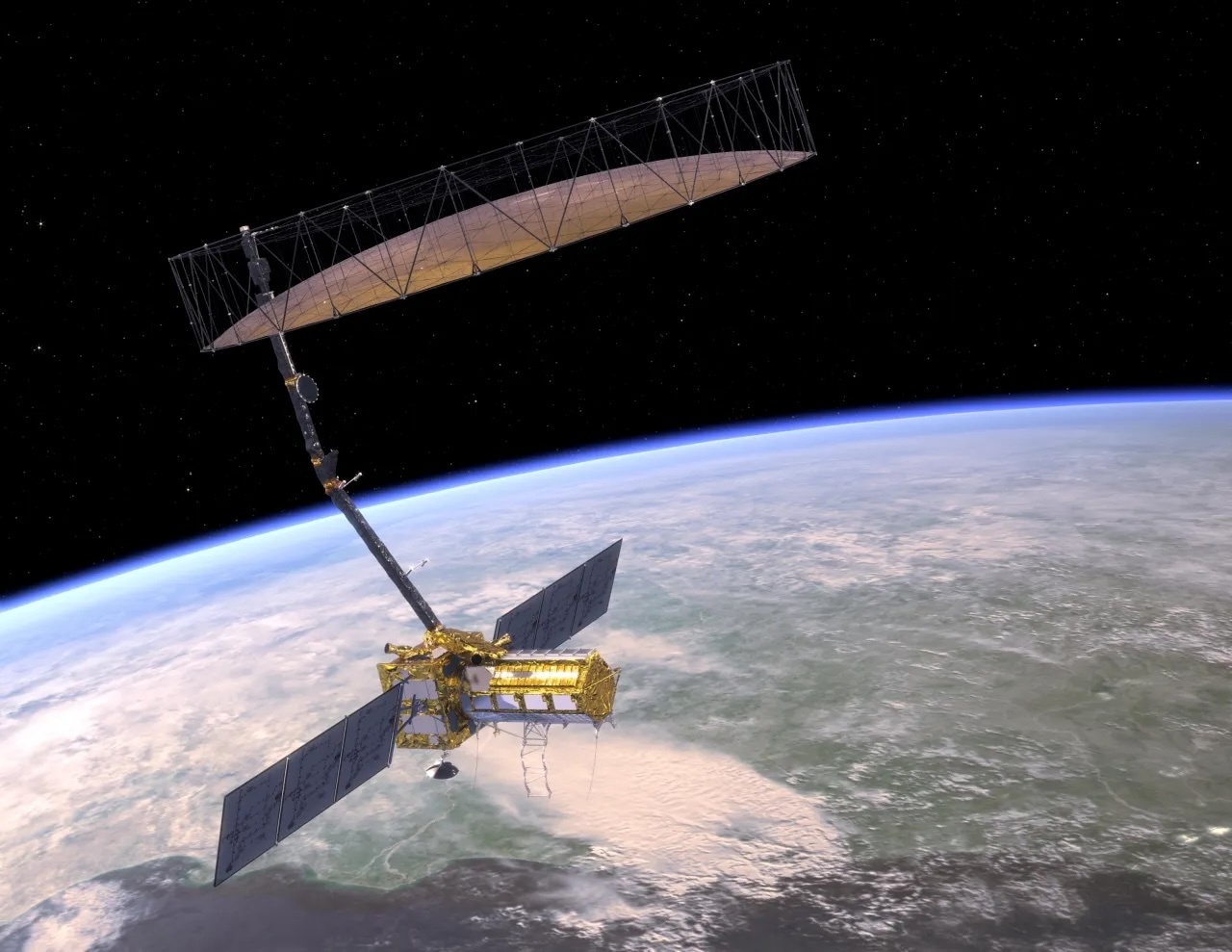
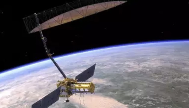
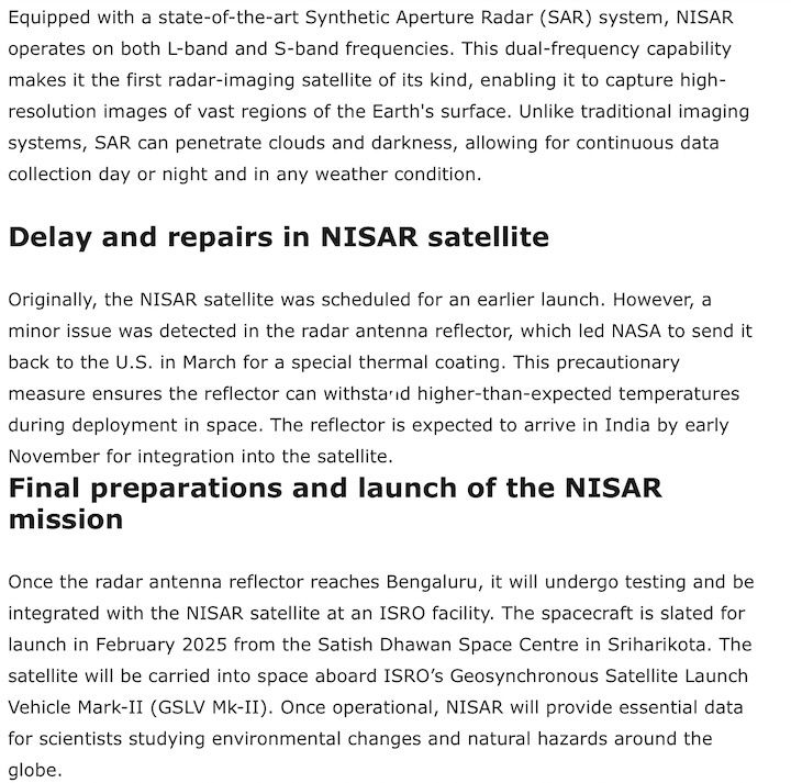
How US-Indian NISAR Satellite Will Offer Unique Window on Earth
An equal collaboration between NASA and the Indian Space Research Organisation, NISAR will offer unprecedented insights into Earth’s constantly changing land and ice surfaces using synthetic aperture radar technology. The spacecraft, depicted here in an artist’s concept, will launch from India.
Credit: NASA/JPL-Caltech
A Q&A with the lead U.S. scientist of the mission, which will track changes in everything from wetlands to ice sheets to infrastructure damaged by natural disasters.
The upcoming U.S.-India NISAR (NASA-ISRO Synthetic Aperture Radar) mission will observe Earth like no mission before, offering insights about our planet’s ever-changing surface.
The NISAR mission is a first-of-a-kind dual-band radar satellite that will measure land deformation from earthquakes, landslides, and volcanoes, producing data for science and disaster response. It will track how much glaciers and ice sheets are advancing or retreating and it will monitor growth and loss of forests and wetlands for insights on the global carbon cycle.
As diverse as NISAR’s impact will be, the mission’s winding path to launch — in a few months’ time — has also been remarkable. Paul Rosen, NISAR’s project scientist at NASA’s Jet Propulsion Laboratory in Southern California, has been there at every step. He recently discussed the mission and what sets it apart.
How will NISAR improve our understanding of Earth?
The planet’s surfaces never stop changing — in some ways small and subtle, and in other ways monumental and sudden. With NISAR, we’ll measure that change roughly every week, with each pixel capturing an area about half the size of a tennis court. Taking imagery of nearly all Earth’s land and ice surfaces this frequently and at such a small scale — down to the centimeter — will help us put the pieces together into one coherent picture to create a story about the planet as a living system.
What sets NISAR apart from other Earth missions?
NISAR will be the first Earth-observing satellite with two kinds of radar — an L-band system with a 10-inch (25-centimeter) wavelength and an S-band system with a 4-inch (10-centimeter) wavelength.
Whether microwaves reflect or penetrate an object depends on their wavelength. Shorter wavelengths are more sensitive to smaller objects such as leaves and rough surfaces, whereas longer wavelengths are more reactive with larger structures like boulders and tree trunks.
So NISAR’s two radar signals will react differently to some features on Earth’s surface. By taking advantage of what each signal is or isn’t sensitive to, researchers can study a broader range of features than they could with either radar on its own, observing the same features with different wavelengths.
Is this new technology?
The concept of a spaceborne synthetic aperture radar, or SAR, studying Earth’s processes dates to the 1970s, when NASA launched Seasat. Though the mission lasted only a few months, it produced first-of-a-kind images that changed the remote-sensing landscape for decades to come.
It also drew me to JPL in 1981 as a college student: I spent two summers analyzing data from the mission. Seasat led to NASA’s Shuttle Imaging Radar program and later to the Shuttle Radar Topography Mission.
What will happen to the data from the mission?
Our data products will fit the needs of users across the mission’s science focus areas — ecosystems, cryosphere, and solid Earth — plus have many uses beyond basic research like soil-moisture and water resources monitoring.
We’ll make the data easily accessible. Given the volume of the data, NASA decided that it would be processed and stored in the cloud, where it’ll be free to access.
How did the ISRO partnership come about?
We proposed DESDynI (Deformation, Ecosystem Structure, and Dynamics of Ice), an L-band satellite, following the 2007 Decadal Survey by the National Academy of Sciences. At the time, ISRO was exploring launching an S-band satellite. The two science teams proposed a dual-band mission, and in 2014 NASA and ISRO agreed to partner on NISAR.
Since then, the agencies have been collaborating across more than 9,000 miles (14,500 kilometers) and 13 time zones. Hardware was built on different continents before being assembled in India to complete the satellite. It’s been a long journey — literally.
More About NISAR
The NISAR mission is an equal collaboration between NASA and ISRO and marks the first time the two agencies have cooperated on hardware development for an Earth-observing mission. Managed for the agency by Caltech, JPL leads the U.S. component of the project and is providing the mission’s L-band SAR. NASA is also providing the radar reflector antenna, the deployable boom, a high-rate communication subsystem for science data, GPS receivers, a solid-state recorder, and payload data subsystem.
Space Applications Centre Ahmedabad, ISRO’s lead center for payload development, is providing the mission’s S-band SAR instrument and is responsible for its calibration, data processing, and development of science algorithms to address the scientific goals of the mission. U R Rao Satellite Centre in Bengaluru, which leads the ISRO components of the mission, is providing the spacecraft bus. The launch vehicle is from ISRO’s Vikram Sarabhai Space Centre, launch services are through ISRO’s Satish Dhawan Space Centre, and satellite mission operations are by ISRO Telemetry Tracking and Command Network. National Remote Sensing Centre in Hyderabad is primarily responsible for S-band data reception, operational products generation, and dissemination.
Quelle: NASA
----
Update: 23.01.2025
.
How New NASA, India Earth Satellite NISAR Will See Earth
Set to launch within a few months, NISAR will use a technique called synthetic aperture radar to produce incredibly detailed maps of surface change on our planet.
When NASA and the Indian Space Research Organization’s (ISRO) new Earth satellite NISAR (NASA-ISRO Synthetic Aperture Radar) launches in coming months, it will capture images of Earth’s surface so detailed they will show how much small plots of land and ice are moving, down to fractions of an inch. Imaging nearly all of Earth’s solid surfaces twice every 12 days, it will see the flex of Earth’s crust before and after natural disasters such as earthquakes; it will monitor the motion of glaciers and ice sheets; and it will track ecosystem changes, including forest growth and deforestation.
The mission’s extraordinary capabilities come from the technique noted in its name: synthetic aperture radar, or SAR. Pioneered by NASA for use in space, SAR combines multiple measurements, taken as a radar flies overhead, to sharpen the scene below. It works like conventional radar, which uses microwaves to detect distant surfaces and objects, but steps up the data processing to reveal properties and characteristics at high resolution.
To get such detail without SAR, radar satellites would need antennas too enormous to launch, much less operate. At 39 feet (12 meters) wide when deployed, NISAR’s radar antenna reflector is as wide as a city bus is long. Yet it would have to be 12 miles (19 kilometers) in diameter for the mission’s L-band instrument, using traditional radar techniques, to image pixels of Earth down to 30 feet (10 meters) across.
Synthetic aperture radar “allows us to refine things very accurately,” said Charles Elachi, who led NASA spaceborne SAR missions before serving as director of NASA’s Jet Propulsion Laboratory in Southern California from 2001 to 2016. “The NISAR mission will open a whole new realm to learn about our planet as a dynamic system.”
How SAR Works
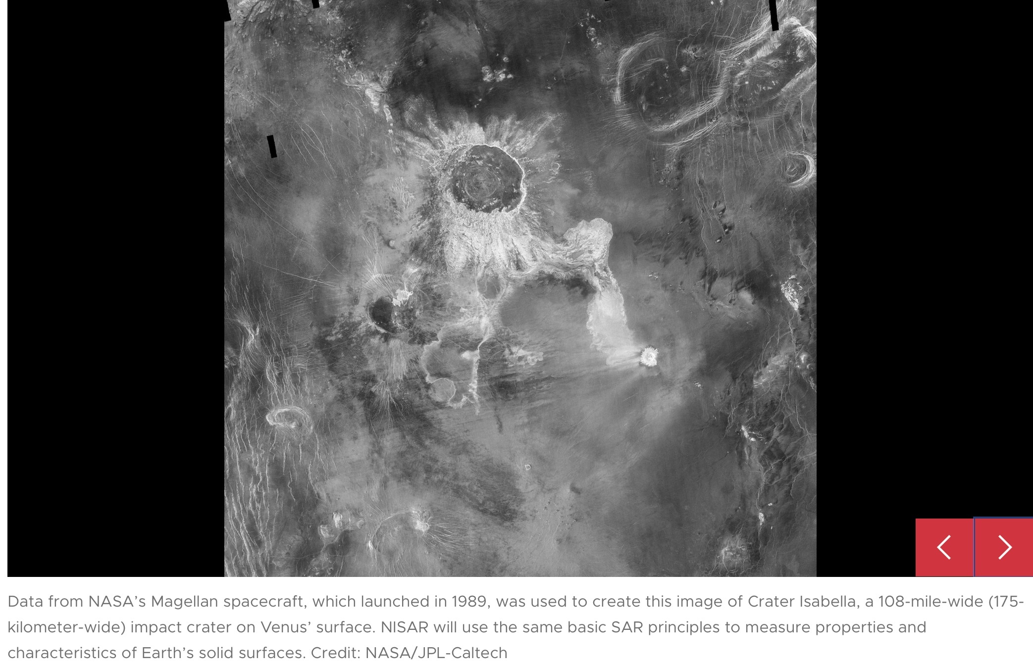
Elachi arrived at JPL in 1971 after graduating from Caltech, joining a group of engineers developing a radar to study Venus’ surface. Then, as now, radar’s allure was simple: It could collect measurements day and night and see through clouds. The team’s work led to the Magellan mission to Venus in 1989 and several NASA space shuttle radar missions.
An orbiting radar operates on the same principles as one tracking planes at an airport. The spaceborne antenna emits microwave pulses toward Earth. When the pulses hit something — a volcanic cone, for example — they scatter. The antenna receives those signals that echo back to the instrument, which measures their strength, change in frequency, how long they took to return, and if they bounced off of multiple surfaces, such as buildings.
This information can help detect the presence of an object or surface, its distance away, and its speed, but the resolution is too low to generate a clear picture. First conceived at Goodyear Aircraft Corp. in 1952, SAR addresses that issue.
“It’s a technique to create high-resolution images from a low-resolution system,” said Paul Rosen, NISAR’s project scientist at JPL.
As the radar travels, its antenna continuously transmits microwaves and receives echoes from the surface. Because the instrument is moving relative to Earth, there are slight changes in frequency in the return signals. Called the Doppler shift, it’s the same effect that causes a siren’s pitch to rise as a fire engine approaches then fall as it departs.
Computer processing of those signals is like a camera lens redirecting and focusing light to produce a sharp photograph. With SAR, the spacecraft’s path forms the “lens,” and the processing adjusts for the Doppler shifts, allowing the echoes to be aggregated into a single, focused image.
Using SAR
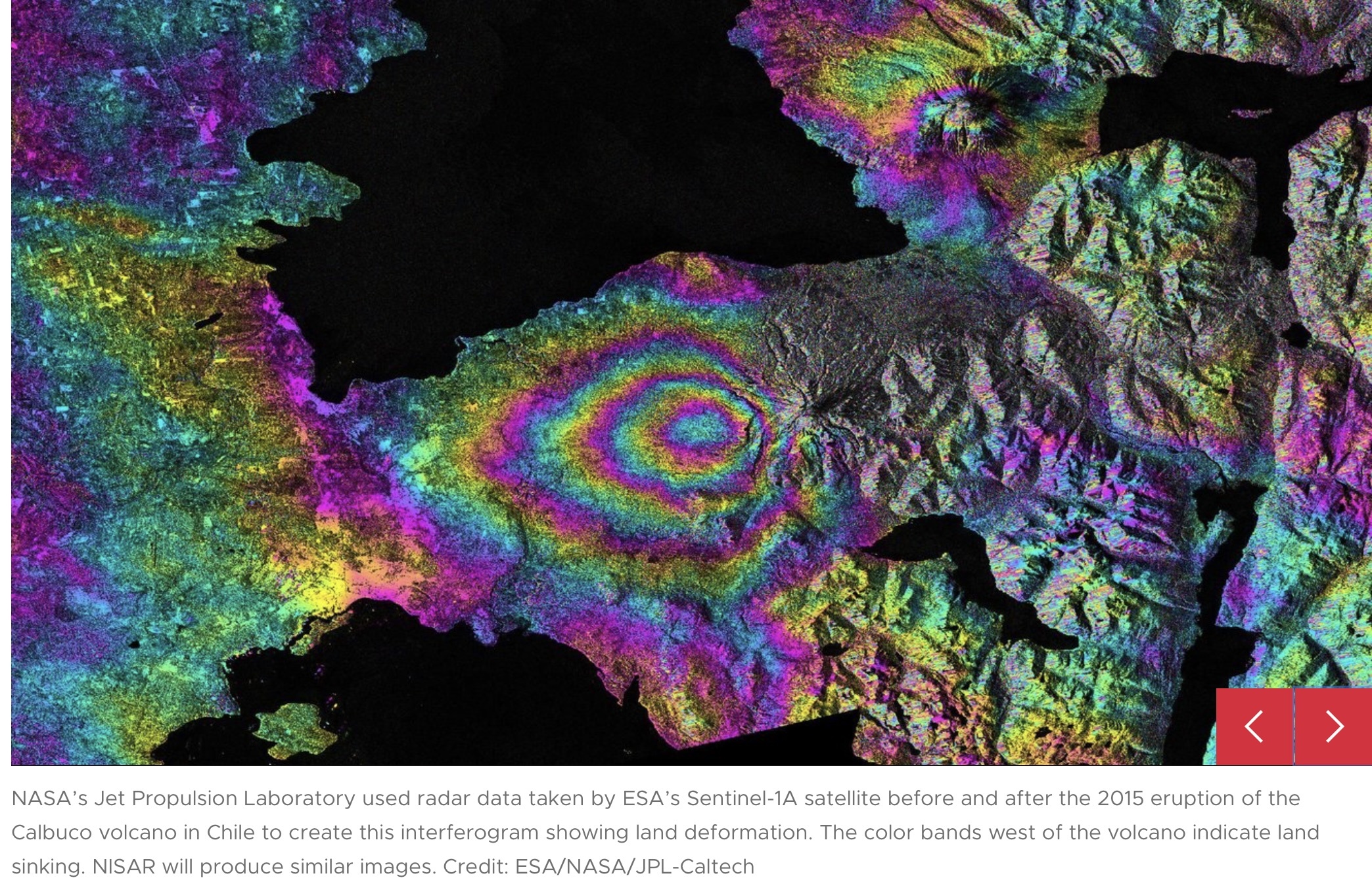
One type of SAR-based visualization is an interferogram, a composite of two images taken at separate times that reveals the differences by measuring the change in the delay of echoes. Though they may look like modern art to the untrained eye, the multicolor concentric bands of interferograms show how far land surfaces have moved: The closer the bands, the greater the motion. Seismologists use these visualizations to measure land deformation from earthquakes.
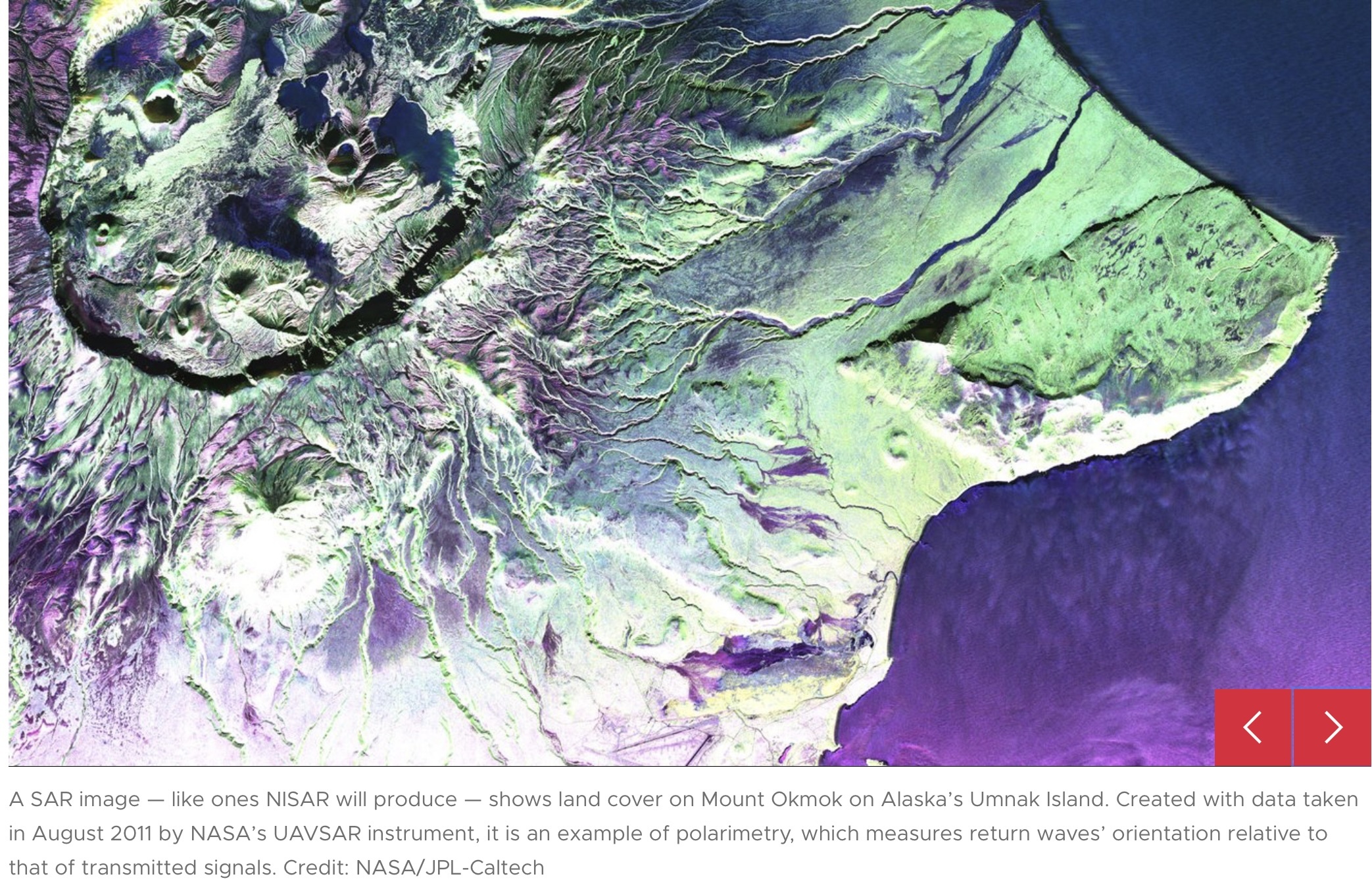
Another type of SAR analysis, called polarimetry, measures the vertical or horizontal orientation of return waves relative to that of transmitted signals. Waves bouncing off linear structures like buildings tend to return in the same orientation, while those bouncing off irregular features, like tree canopies, return in another orientation. By mapping the differences and the strength of the return signals, researchers can identify an area’s land cover, which is useful for studying deforestation and flooding.
Such analyses are examples of ways NISAR will help researchers better understand processes that affect billions of lives.
“This mission packs in a wide range of science toward a common goal of studying our changing planet and the impacts of natural hazards,” said Deepak Putrevu, co-lead of the ISRO science team at the Space Applications Centre in Ahmedabad, India.
Quelle: NASA
----
Update: 22.04.2025
.
Delayed but on track: ISRO locks in June launch for ₹5,800 crore NISAR satellite
Developed over more than a decade, the NASA-ISRO Synthetic Aperture Radar (NISAR) mission is the first Earth-observing satellite to feature dual-frequency synthetic aperture radar — NASA’s L-band and ISRO’s S-band.
Weighing 2.8 tonnes, the satellite will scan nearly the entire globe every 12 days, delivering high-resolution data crucial for monitoring earthquakes, glaciers, land use and climate change.
After months of delays and technical hurdles, India has locked in June 2025 for the launch of the high-stakes NISAR satellite, a landmark Earth observation mission co-developed with NASA. In a parallel boost to India’s space ambitions, ISRO also confirmed its upcoming involvement in the Axiom Mission 4 (Ax-4), setting the stage for a pivotal year in India’s cosmic trajectory.
ISRO Chairman V Narayanan shared the updates during a meeting with Science Minister Jitendra Singh, outlining key developments in India's upcoming space calendar.
Narayanan confirmed that the NISAR satellite, delayed due to issues during assembly — particularly with its 12-metre radar antenna reflector — will finally lift off aboard a GSLV-F16 rocket from Sriharikota. While the specific date remains unannounced, the June timeline is now official.
Developed over more than a decade, the NASA-ISRO Synthetic Aperture Radar (NISAR) mission is the first Earth-observing satellite to feature dual-frequency synthetic aperture radar — NASA’s L-band and ISRO’s S-band. This unique tech enables it to track surface changes with centimeter-level precision, even through clouds and dense vegetation.
Weighing 2.8 tonnes and costing upwards of ₹5,800 crore, the satellite will scan nearly the entire globe every 12 days, delivering high-resolution data crucial for monitoring earthquakes, glaciers, land use and climate change. According to NASA, this data will be key in understanding natural disasters, environmental degradation, and infrastructure stress.
Its hardware jointly developed in the US and India includes advanced radar systems, deployable booms, GPS units, and a high-speed data network. With its cloud-based storage and open-access policy, NISAR promises to aid researchers and policymakers worldwide.
The satellite's confirmation adds to a growing list of Indian space ventures, including the Gaganyaan crewed mission and the country’s debut on the International Space Station through the US-led Axiom Mission 4.
Quelle: Business Today
----
Update: 29.04.2025
.
Isro begins preparation to launch Nisar mission to space aboard GSLV Mk-II
ISRO Chairman V Narayanan recently indicated an upcoming 2025 launch window during a meeting with Science Minister Jitendra Singh.
- ISRO finalises preparations for Nisar mission with Nasa
- Launch delayed to 2025 due to technical issues with radar
- Nisar to use dual-band radar for high-resolution Earth observation
The Indian Space Research Organisation (ISRO) has entered the final phase of preparations for the NASA-ISRO Synthetic Aperture Radar (Nisar) mission, a collaboration set to revolutionise Earth observation.
Initially planned for 2024, the launch faced multiple delays due to technical challenges, including overheating risks in the satellite’s 12-meter radar antenna reflector.
The component was shipped back to NASA’s Jet Propulsion Laboratory (JPL) in 2024 for a reflective coating upgrade to mitigate temperature concerns during deployment.
Quelle:INDIA TODAY