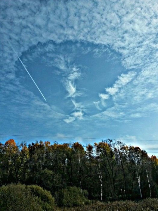
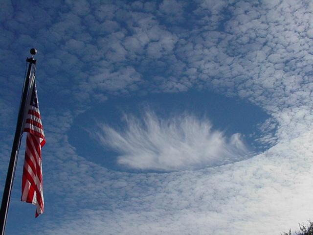
Heute (2.01.2014) bekamen wir folgendes Foto mit dieser Email:
Hallo Herr Köhler,
Zusammen mit einem Schüler von mir haben wir vor ca. 3 Monaten folgendes Bild aufgenommen über Pegnitz/Oberfranken.
Kann mir bis heute keinen Reim darauf machen wie diese Wolkenformation zu erklären ist zuvor gab es einen hellen Lichtblitz!
Bitte schauen Sie sich das doch einmal an!
Gesundes neues Jahr!
mit freundlichen Grüßen
W.Steiner
Bei diesem Phänomen handelt es sich um eine Hole-Punch Cloud (übersetzt Lochstanz-Wolke). Flugzeuge stanzen dabei tatsächlich Löcher in die Wolken. Wenn keine Staubpartikel in der Luft vorhanden sind, an die sich Wassertröpfchen anlagern können, gefrieren sie erst bei einer Temperatur von etwa minus 36 Grad Celsius. Fliegt nun ein Flugzeug durch eine Wolke, die bereits auf minus 15 bis 20 Grad abgekühlt ist, führt der Luftzug über den Tragflächen oder dem Propeller dazu, dass sich die Luft ausdehnt. In einem kreisrunden, abgegrenztem Gebiet kühlt die Wolke so ab, dass die Wassertropfen gefrieren, Eiskristalle bilden und zu Boden fallen.
CENAP-Mannheim
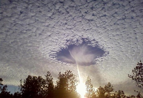
Nachfolgend Beispiel-Erklärung zu Hole-Punch Cloud:
-
Strange-looking hole-punch clouds are made by jets
It might look like a UFO – but it’s really a hole-punch cloud. A scientist talked with EarthSky about the connection between hole-punch clouds, jets and snowfall.
.
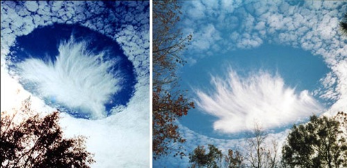
November 1, 2014. Caledonia, Wisconsin. Photo credit: Lisa Anderson
.
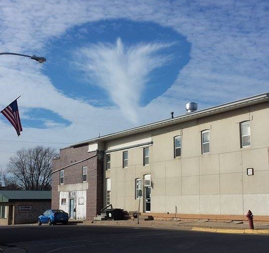
You’re probably familiar with contrails, the wispy strands of clouds made by jet exhaust high in the sky. But you might never have seen a hole-punch cloud. They’re very strange clearings in the cloud cover – clear patches of sky, often with a circular shape. Sometimes people report them as UFOs. Airplanes create hole-punch clouds – but just how do thy do it?
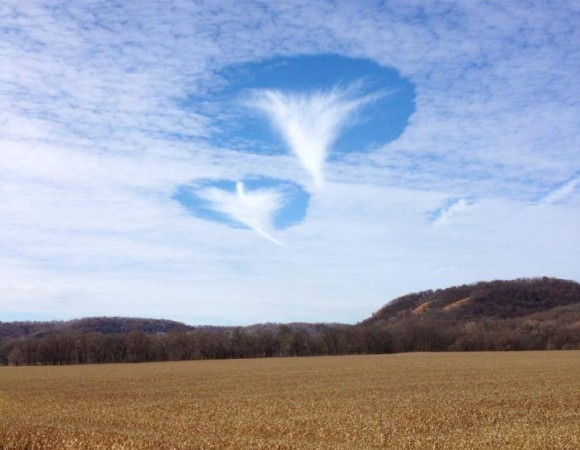
Hole-punch cloud image provided by Andrew Heymsfield. Used with permission
.
Houston, Minnesota. Photo credit: Jamie Vix
.
EarthSky spoke with Andrew Heymsfield, a senior scientist with the National Center for Atmospheric Research. He led a team that showed a relationship between these strange-looking clouds, jet aircraft and snowfall. He told EarthSky:
This whole idea of jet aircraft making these features has to do with cooling of air over the wings that generates ice.
His team found that – at lower altitudes – jets can punch holes in clouds and make small amounts of rain and snow. As a plane flies through mid-level clouds, it forces air to expand rapidly and cool. Water droplets in the cloud freeze to ice and then turn to snow as they fall. The gap expands to create spectacular holes in the clouds. He said:
.
Image Credit: NOAA
.
We found an exemplary case of hole-punch clouds over Texas. From satellite imagery you could see holes just pocketing the sky, holes and long channels where aircraft had been flying at that level of the cloud for a while.
Dr. Heymsfield used a weather forecast model developed at NCAR – and radar images of clouds from NASA’s CloudSat satellite – to explain the physics of how jet aircraft make hole-punch clouds.
Heymsfield’s team found that every measurable commercial jet aircraft, private jet aircraft and also military jets as well as turbo props were producing these holes. He said a hole-punch cloud expands for hours after being created. Major airports, where there’s a lot of aircraft traffic, would be a good place to study cloud holes. He said:
What we decided to do was look at major airports around the world, especially where there’s low cloud cover and cold clouds in the wintertime, and found that the frequency of occurrence suitable for this process to occur is actually reasonably high, on the order of three to five percent. In the winter months, it’s probably two to three times higher, 10 to 15 percent.
.
Hole-punch cloud image provided by Andrew Heymsfield. Used with permission
.
He said people who look out their airplane window in flight can see for themselves how the wing changes a cloud.
When an aircraft lands or takes off sometimes – especially in humid, tropical areas – you see a little veil of clouds over the wings of the aircraft. And basically, what’s happening over the wings of the aircraft, there’s cooling. And the cooling produces a cloud.
It’s basically a super-cooled cloud. It’s just like a fog you see at the ground except that its temperature is zero degrees centigrade. So in that process of expanding, the air expands over the wing and cools. And that cooling can be as much as 20 degrees centigrade.
The cooling of air over the wings generates ice, said Heymsfield. He said:
We speculated on that and suggested that this was another process to produce holes in clouds. Our results were published in July 2011 in the journal Science.
About the Texas incident where satellite imagery showed many hole-punch openings and channels, Heymsfield said:
What we found was that there were about a hundred of these little features. We decided to, first of all, identify their location and see if we could link them to particular aircraft. Then the second thing we did was say, okay, why do these long channels last for the period of time it would take for a satellite to take a snapshot of them? We got high-time-resolution satellite imagery and were able then to track these features, these holes, and watch them develop with time, watch how they developed.
Bottom Line: Scientists have found that, at mid-altitudes, jet aircraft can punch holes in clouds and make small amounts of rain and snow. These are the strange hole-punch clouds that are sometimes reported as UFOs. Andrew Heymsfield, a senior scientist with the National Center for Atmospheric Research, led a team that showed a relationship between these strange-looking clouds, airplanes and snowfall.