
.
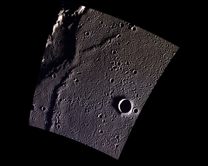
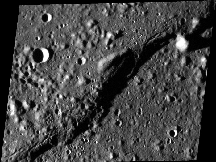
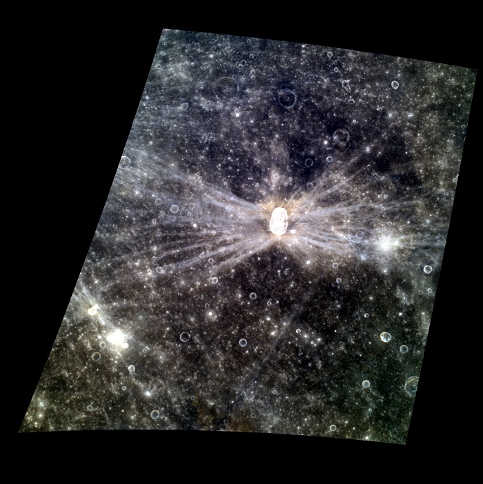
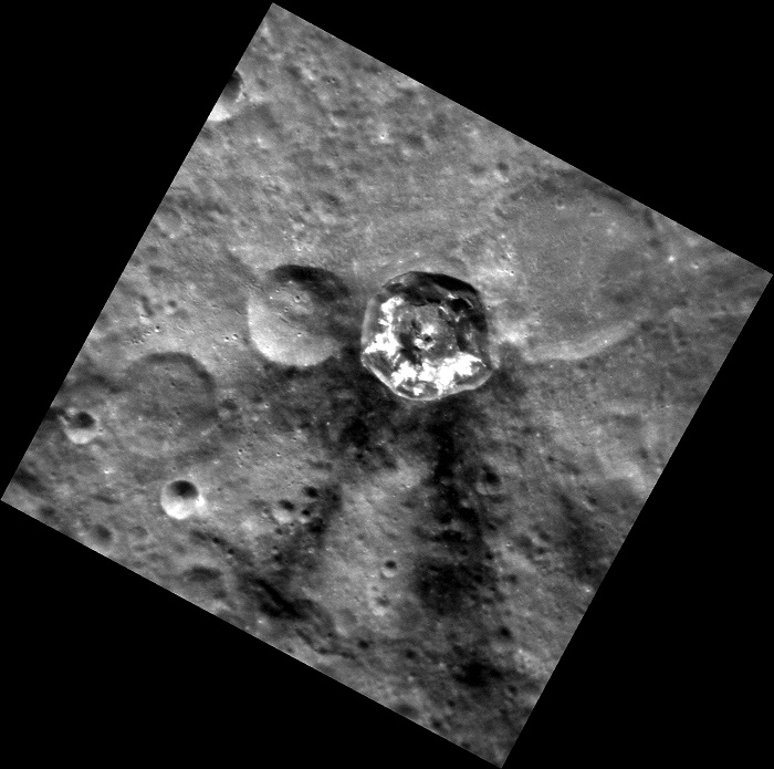
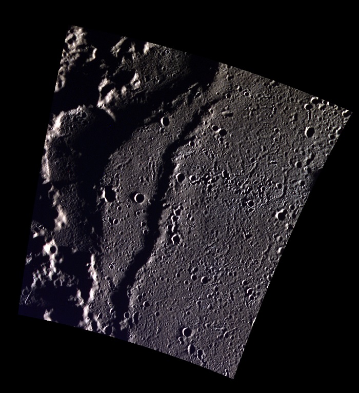
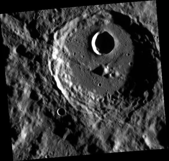
| Date acquired: February 09, 2013 Image Mission Elapsed Time (MET): 2721322, 2721314, 2721318 Image ID: 3487267, 3487265, 3487266 Instrument: Wide Angle Camera (WAC) of the Mercury Dual Imaging System (MDIS) WAC filters: 9, 7, 6 (996, 748, 433 nanometers) in red, green, and blue Center Latitude: 83.35° Center Longitude: 291.6° E Resolution: 86 meters/pixel Scale: The larger crater in this image is 9.5 km in diameter (6 miles). Incidence Angle: 87.6° Emission Angle: 18.9° Phase Angle: 87.5° Of Interest: This small unnamed crater occurs near a wrinkle ridge in Goethe Basin. Since this image was taken near the north pole of Mercury, the shadows are more dramatic than in the equatorial region. This image was acquired as part of MDIS's high-resolution 3-color imaging campaign. The map produced from this campaign complements the 8-color base map (at an average resolution of 1 km/pixel) acquired during MESSENGER's primary mission by imaging Mercury's surface in a subset of the color filters at the highest resolution possible. The three narrow-band color filters are centered at wavelengths of 430 nm, 750 nm, and 1000 nm, and image resolutions generally range from 100 to 400 meters/pixel in the northern hemisphere. The MESSENGER spacecraft is the first ever to orbit the planet Mercury, and the spacecraft's seven scientific instruments and radio science investigation are unraveling the history and evolution of the Solar System's innermost planet. During the first two years of orbital operations, MESSENGER acquired over 150,000 images and extensive other data sets. MESSENGER is capable of continuing orbital operations until early 2015. |
|
Credit: NASA/Johns Hopkins University Applied Physics Laboratory/Carnegie Institution of Washington |
.
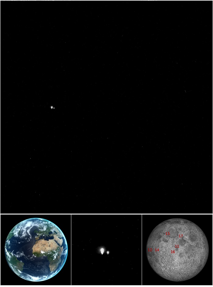
| Date Acquired: July 19, 2013, 11:54:41 UTC Image Mission Elapsed Time (MET): 1016558881 Instrument: Wide Angle Camera (WAC) of the Mercury Dual Imaging System (MDIS) WAC Filter: 2 (clear filter) Field of View: The WAC has a 10.5° field of view The pair of bright star-like features in the upper panel are not stars at all, but the Earth and Moon! MESSENGER was at a distance of 98 million kilometers (61 million miles) from Earth when this picture was taken. The computer-generated image in the lower left shows how the Earth appeared from Mercury at the time. Much of the Americas, all of Europe and Africa, the Middle East, and much of Asia were visible. MESSENGER took this image as part of a campaign to search for natural satellites of Mercury. Mercury has no moons that we know of. If any exist, they must be small (less than a few kilometers), or we would have seen them by now. The strategy for the satellite search involves taking multiple images of locations at predetermined distances from Mercury, from 2.5 to 25 times the planet radius. Pictures of these points in space are captured at intervals ranging from seconds to nearly an hour, depending on their distances from Mercury. A moving satellite will appear at different positions in images of the same region of space taken at different times. The Earth and Moon appear very large in this picture because they are overexposed. When looking for potentially dim satellites, long exposures are required to capture as much light as possible. Consequently, bright objects in the field of view become saturated and appear artificially large. In fact, the Earth and Moon are each less than a pixel in size, and no details on either can be seen. The “tails” pointing downward from the Earth and Moon are artifacts caused by the image saturation. These can be seen clearly in the zoomed image in the center lower panel. This image was taken on the same day that images with Earth in the scene were acquired by the Cassini spacecraft, as part of a mosaic of the backlit Saturn system. One day later in the search for satellites of Mercury, MESSENGER again took similar images of the Earth and Moon. The date of those images, July 20, was the 44th anniversary of the Apollo 11 landing on the Moon. All six Apollo landing sites are illuminated in the MESSENGER images, although they cannot be resolved. Their locations are marked on the simulated image in the lower right panel. The background for this image is the region between the constellations Sagittarius (the archer) and Scutum (the shield). The right ascension and declination of Earth are 18h 55m 44s and -18° 25' 31", respectively. Pluto is also in the field of view but far too dim to be seen. |
|
Credit: NASA/Johns Hopkins University Applied Physics Laboratory/Carnegie Institution of Washington |
.
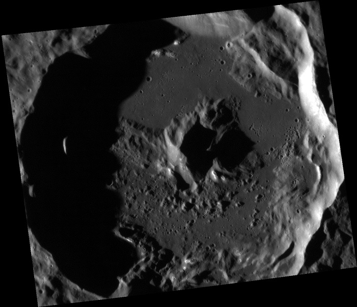
|
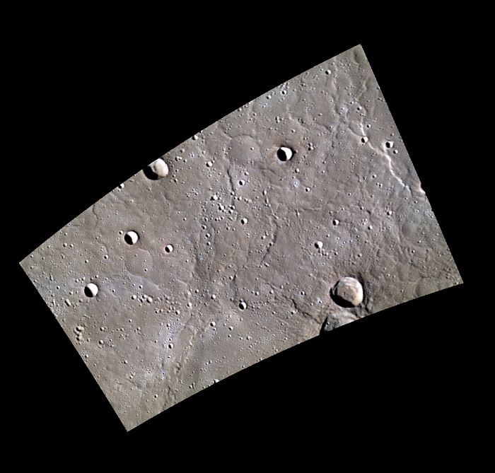
Date acquired: April 18, 2013 |
|
Credit: NASA/Johns Hopkins University Applied Physics Laboratory/Carnegie Institution of Washington |
.
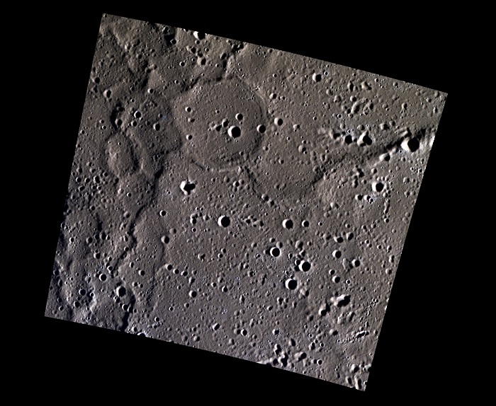
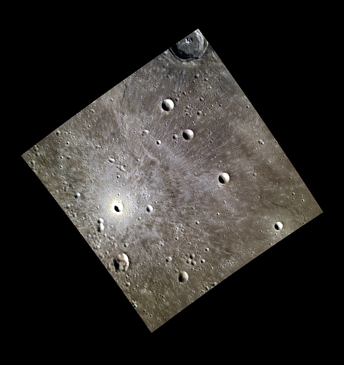
| Date acquired: February 13, 2013 Image Mission Elapsed Time (MET): 3038383, 3038375, 3038379 Image ID: 3509798, 3509796, 3509797 Instrument: Wide Angle Camera (WAC) of the Mercury Dual Imaging System (MDIS) WAC filters: 9, 7, 6 (996, 748, 433 nanometers) in red, green, and blue Center Latitude: 69.58° Center Longitude: 284.1° E Resolution: 91 meters/pixel Scale: The ghost crater is 21 km (13 miles) in diameter. Incidence Angle: 84.9° Emission Angle: 0.1° Phase Angle: 85.0° Of Interest: The northern plains on Mercury have lower elevation than surrounding regions. This view of the northern plains includes many wrinkle ridges, a result of tectonic deformation. The ridges outline the rim of a ghost crater, formed when lava covered the crater and differential sagging took place over the rim. The ghost rim is joined by four other prominent ridges. This image was acquired as part of MDIS's high-resolution 3-color imaging campaign. The map produced from this campaign complements the 8-color base map (at an average resolution of 1 km/pixel) acquired during MESSENGER's primary mission by imaging Mercury's surface in a subset of the color filters at the highest resolution possible. The three narrow-band color filters are centered at wavelengths of 430 nm, 750 nm, and 1000 nm, and image resolutions generally range from 100 to 400 meters/pixel in the northern hemisphere. The MESSENGER spacecraft is the first ever to orbit the planet Mercury, and the spacecraft's seven scientific instruments and radio science investigation are unraveling the history and evolution of the Solar System's innermost planet. During the first two years of orbital operations, MESSENGER acquired over 150,000 images and extensive other data sets. MESSENGER is capable of continuing orbital operations until early 2015. |
|
Credit: NASA/Johns Hopkins University Applied Physics Laboratory/Carnegie Institution of Washington |
.
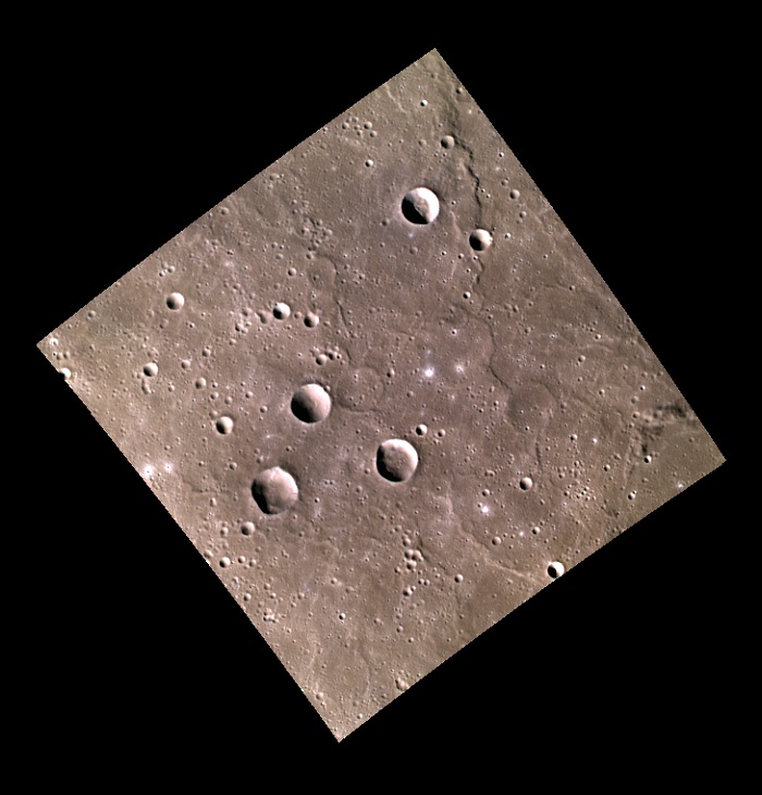
| Date acquired: February 15, 2013 Image Mission Elapsed Time (MET): 3211541 Image ID: 3522080 Instrument: Wide Angle Camera (WAC) of the Mercury Dual Imaging System (MDIS) WAC filter: 7 (748 nanometers) Center Latitude: 50.01° Center Longitude: 281.1° E Resolution: 256 meters/pixel Scale: The smaller crater in the upper left is 7.8 km (4.8 miles) in diameter. Incidence Angle: 82.7° Emission Angle: 0.1° Phase Angle: 82.7° Of Interest: This image is of the southern rim of the crater Stravinsky. In this high-incidence-angle lighting, the topography of the crater is easily seen. Particularly noticeable is the difference between the crater's flat floor and the hummocky terrain of the ejecta blanket outside the crater. The area in the lower left of the image is part of the Vyasa basin. Since Stravinsky's ejecta overlaps Vyasa, we can deduce that Stravinsky is younger than Vyasa. This image was acquired as part of MDIS's high-incidence-angle base map. The high-incidence-angle base map complements the surface morphology base map of MESSENGER's primary mission that was acquired under generally more moderate incidence angles. High incidence angles, achieved when the Sun is near the horizon, result in long shadows that accentuate the small-scale topography of geologic features. The high-incidence-angle base map was acquired with an average resolution of 200 meters/pixel. The MESSENGER spacecraft is the first ever to orbit the planet Mercury, and the spacecraft's seven scientific instruments and radio science investigation are unraveling the history and evolution of the Solar System's innermost planet. During the first two years of orbital operations, MESSENGER acquired over 150,000 images and extensive other data sets. MESSENGER is capable of continuing orbital operations until early 2015. |
|
Credit: NASA/Johns Hopkins University Applied Physics Laboratory/Carnegie Institution of Washington |
.
| Date acquired: February 08, 2013 Image Mission Elapsed Time (MET): 2613780 Image ID: 3479116 Instrument: Wide Angle Camera (WAC) of the Mercury Dual Imaging System (MDIS) WAC filter: 9 (996 nanometers) Center Latitude: -80.38° Center Longitude: 302.4° E Resolution: 1486 meters/pixel Scale: The complex crater in the center of the image is 151 km in diameter (94 miles). Incidence Angle: 85.0° Emission Angle: 25.8° Phase Angle: 59.1° Of Interest: This image of Mercury's southern hemisphere shows the large size variation and multiple generations of impact craters on Mercury. Mercury's southern hemisphere is easier to image due to MESSENGER's elliptical orbit, but this orbit also prevents acquisition of high resolution images like those taken in the northern hemisphere. The MESSENGER spacecraft is the first ever to orbit the planet Mercury, and the spacecraft's seven scientific instruments and radio science investigation are unraveling the history and evolution of the Solar System's innermost planet. During the first two years of orbital operations, MESSENGER acquired over 150,000 images and extensive other data sets. MESSENGER is capable of continuing orbital operations until early 2015. |
|
Credit: NASA/Johns Hopkins University Applied Physics Laboratory/Carnegie Institution of Washington |
.
| Date acquired: June 06, 2013 Image Mission Elapsed Time (MET): 12802777, 12802773, 12802771 Image ID: 4204118, 4204116, 4204115 Instrument: Wide Angle Camera (WAC) of the Mercury Dual Imaging System (MDIS) WAC filters: 9, 7, 6 (996, 748, 433 nanometers) in red, green, and blue Center Latitude: 42.53° Center Longitude: 154.2° E Resolution: 265 meters/pixel Scale: Crater diameter is about 51 km (31.7 miles) Incidence Angle: 42.9° Emission Angle: 26.5° Phase Angle: 69.4° Of Interest: Today's color image highlights the bright hollows on the floor and peaks of Sander crater, named after the German photographer August Sander. The process responsible for these bright, shallow formations is still unknown, but it is possible that volatile sublimation is etching away at the surface. This image was acquired as a targeted high-resolution 11-color image set. Acquiring 11-color targets is a new campaign that began in March 2013 and that utilizes all of the WAC's 11 narrow-band color filters. Because of the large data volume involved, only features of special scientific interest are targeted for imaging in all 11 colors. The MESSENGER spacecraft is the first ever to orbit the planet Mercury, and the spacecraft's seven scientific instruments and radio science investigation are unraveling the history and evolution of the Solar System's innermost planet. During the first two years of orbital operations, MESSENGER acquired over 150,000 images and extensive other data sets. MESSENGER is capable of continuing orbital operations until early 2015. |
|
Credit: NASA/Johns Hopkins University Applied Physics Laboratory/Carnegie Institution of Washington |
.
| Date acquired: July 08, 2013 Image Mission Elapsed Time (MET): 15627633 Image ID: 4404792 Instrument: Narrow Angle Camera (NAC) of the Mercury Dual Imaging System (MDIS) Center Latitude: 20.47° Center Longitude: 141.0° E Resolution: 51 meters/pixel Scale: Image width is about 65 km (40.4 miles) Incidence Angle: 83.4° Emission Angle: 38.9° Phase Angle: 45.4° Of Interest: Today's image features a scarp, or cliff face, which is longer than the 77 km shown in this frame. Scarps form as one block of crust is thrusted forward over another, which can result from the cooling of the planet's interior causing global contraction. On Mercury, scarps are called "rupes," which is Latin for cliff. This image was acquired as a high-resolution targeted observation. Targeted observations are images of a small area on Mercury's surface at resolutions much higher than the 200-meter/pixel morphology base map. It is not possible to cover all of Mercury's surface at this high resolution, but typically several areas of high scientific interest are imaged in this mode each week. The MESSENGER spacecraft is the first ever to orbit the planet Mercury, and the spacecraft's seven scientific instruments and radio science investigation are unraveling the history and evolution of the Solar System's innermost planet. During the first two years of orbital operations, MESSENGER acquired over 150,000 images and extensive other data sets. MESSENGER is capable of continuing orbital operations until early 2015. |
|
Credit: NASA/Johns Hopkins University Applied Physics Laboratory/Carnegie Institution of Washington |
.
| Date acquired: May 01, 2013 Image Mission Elapsed Time (MET): 9751363, 9751355, 9751351 Image ID: 3986986, 3986984, 3986983 Instrument: Wide Angle Camera (WAC) of the Mercury Dual Imaging System (MDIS) WAC filters: 9, 7, 6 (996, 748, 433 nanometers) in red, green, and blue Center Latitude: -7.39° Center Longitude: 172.9° E Resolution: 394 meters/pixel Scale: Hovnatanian crater is about 34 km (21 miles) long. Incidence Angle: 15.7° Emission Angle: 40.0° Phase Angle: 28.0° Of Interest: Today's color image features Hovnatanian crater, named for Armenian painter Hakop Hovnatanian. The crater's elliptical shape and the bright rays' butterfly pattern indicate that a very oblique impact produced Hovnatanian. The brightness of the rays indicate that they are relatively young features on Mercury's surface. This image was acquired as a targeted high-resolution 11-color image set. Acquiring 11-color targets is a new campaign that began in March 2013 and that utilizes all of the WAC's 11 narrow-band color filters. Because of the large data volume involved, only features of special scientific interest are targeted for imaging in all 11 colors. The MESSENGER spacecraft is the first ever to orbit the planet Mercury, and the spacecraft's seven scientific instruments and radio science investigation are unraveling the history and evolution of the Solar System's innermost planet. During the first two years of orbital operations, MESSENGER acquired over 150,000 images and extensive other data sets. MESSENGER is capable of continuing orbital operations until early 2015. |
|
Credit: NASA/Johns Hopkins University Applied Physics Laboratory/Carnegie Institution of Washington |
.
| Date acquired: June 29, 2013 Image Mission Elapsed Time (MET): 14849521 Image ID: 4349591 Instrument: Narrow Angle Camera (NAC) of the Mercury Dual Imaging System (MDIS) Center Latitude: 30.56° Center Longitude: 163.3° E Resolution: 34 meters/pixel Scale: Apollodorus crater is approximately 41 km (25.5 mi.) in diameter. Incidence Angle: 77.4° Emission Angle: 32.6° Phase Angle: 110.0° Of Interest: Today's image highlights the striking central uplift of the Apollodorus Crater, located near the center of the Caloris basin. Such peak structures form in complex craters when material is uplifted from depth as a result of the impact process. This image was acquired as a high-resolution targeted observation. Targeted observations are images of a small area on Mercury's surface at resolutions much higher than the 200-meter/pixel morphology base map. It is not possible to cover all of Mercury's surface at this high resolution, but typically several areas of high scientific interest are imaged in this mode each week. The MESSENGER spacecraft is the first ever to orbit the planet Mercury, and the spacecraft's seven scientific instruments and radio science investigation are unraveling the history and evolution of the Solar System's innermost planet. During the first two years of orbital operations, MESSENGER acquired over 150,000 images and extensive other data sets. MESSENGER is capable of continuing orbital operations until early 2015. |
|
Credit: NASA/Johns Hopkins University Applied Physics Laboratory/Carnegie Institution of Washington |
.
| Date acquired: September 03, 2012 Image Mission Elapsed Time (MET): 255173197, 255173189, 255173193 Image ID: 2512508, 2512506, 2512507 Instrument: Wide Angle Camera (WAC) of the Mercury Dual Imaging System (MDIS) WAC filters: 9, 7, 6 (996, 748, 433 nanometers) in red, green, and blue Center Latitude: 46.39° Center Longitude: 45.05° E Resolution: 158 meters/pixel Scale: Bright Crater Diameter : 6.2 km (3.85 mi) Incidence Angle: 61.4° Emission Angle: 0.1° Phase Angle: 61.5° Of Interest: The bright rays of this unnamed crater mark the path of its ejecta, which swept across the volcanic plains that cover a large portion of Mercury's northern polar region. The high reflectance and beautifully preserved rays indicate the crater is one of the youngest impacts of its size on Mercury. This image was acquired as part of MDIS's high-resolution 3-color imaging campaign. The map produced from this campaign complements the 8-color base map (at an average resolution of 1 km/pixel) acquired during MESSENGER's primary mission by imaging Mercury's surface in a subset of the color filters at the highest resolution possible. The three narrow-band color filters are centered at wavelengths of 430 nm, 750 nm, and 1000 nm, and image resolutions generally range from 100 to 400 meters/pixel in the northern hemisphere. The MESSENGER spacecraft is the first ever to orbit the planet Mercury, and the spacecraft's seven scientific instruments and radio science investigation are unraveling the history and evolution of the Solar System's innermost planet. During the first two years of orbital operations, MESSENGER acquired over 150,000 images and extensive other data sets. MESSENGER is capable of continuing orbital operations until early 2015. |
|
Credit: NASA/Johns Hopkins University Applied Physics Laboratory/Carnegie Institution of Washington |
.
| Date acquired: September 03, 2012 Image Mission Elapsed Time (MET): 255173296, 255173291, 255173293 Image ID: 2512514, 2512512, 2512513 Instrument: Wide Angle Camera (WAC) of the Mercury Dual Imaging System (MDIS) WAC filters: 9, 7, 6 (996, 748, 433 nanometers) in red, green, and blue Center Latitude: 51.83° Center Longitude: 46.39° E Resolution: 279 meters/pixel Scale:Image Size: 188 km (117 mi) Incidence Angle: 65.2° Emission Angle: 0.2° Phase Angle: 65.4° Of Interest: The very smooth region shown in this image is a part of Mercury's vast northern plains. These smooth plains are thought to have originated as volcanic outflows, in a similar manner to those within the Caloris basin. If you look closely, you can see several impact craters that were buried beneath the lava. These craters are known as "ghost craters" because only faint outlines of their rims remain. This image was acquired as part of MDIS's high-resolution 3-color imaging campaign. The map produced from this campaign complements the 8-color base map (at an average resolution of 1 km/pixel) acquired during MESSENGER's primary mission by imaging Mercury's surface in a subset of the color filters at the highest resolution possible. The three narrow-band color filters are centered at wavelengths of 430 nm, 750 nm, and 1000 nm, and image resolutions generally range from 100 to 400 meters/pixel in the northern hemisphere. The MESSENGER spacecraft is the first ever to orbit the planet Mercury, and the spacecraft's seven scientific instruments and radio science investigation are unraveling the history and evolution of the Solar System's innermost planet. During the first two years of orbital operations, MESSENGER acquired over 150,000 images and extensive other data sets. MESSENGER is capable of continuing orbital operations until early 2015. |
|
Credit: NASA/Johns Hopkins University Applied Physics Laboratory/Carnegie Institution of Washington |
.
Date acquired: August 30, 2011
Image Mission Elapsed Time (MET): 223185654
Image ID: 695876
Instrument: Narrow Angle Camera (NAC) of the Mercury Dual Imaging System (MDIS)
Center Latitude: -40.07°
Center Longitude: 345.8° E
Resolution: 98 meters/pixel
Scale: Matabei is 24 km. in diameter (15 mi.)
Incidence Angle: 42.4°
Emission Angle: 6.4°
Phase Angle: 46.6°
Of Interest: The crater Matabei, shown here, exhibits a dark ray system projecting from one side of the crater. Rays emanating from only certain sides of the crater can be due to an impactor that came in at a grazing angle, such as seen for the craters Hovnatanian and Qi Baishi. However dark rays like these can also indicate an irregular distribution of dark material below the surface. The dark rays are likely sub-surface material that was excavated and ejected out during the initial impact. It is also interesting to note the extensive hollows, identifiable as the bright regions in the southern half of the crater.
This image was acquired as a high-resolution targeted observation. Targeted observations are images of a small area on Mercury's surface at resolutions much higher than the 200-meter/pixel morphology base map. It is not possible to cover all of Mercury's surface at this high resolution, but typically several areas of high scientific interest are imaged in this mode each week.
.
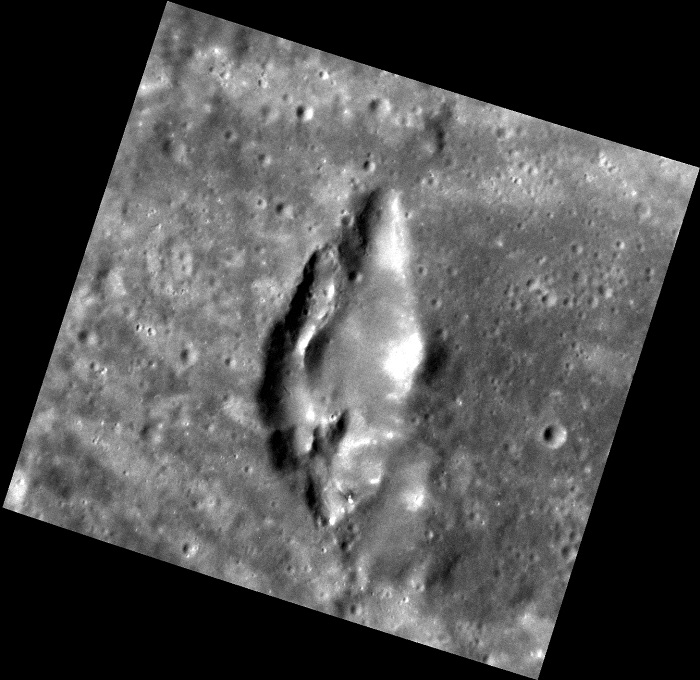
Date acquired: August 16, 2011
Image Mission Elapsed Time (MET): 221974660
Image ID: 638531
Instrument: Narrow Angle Camera (NAC) of the Mercury Dual Imaging System (MDIS)
Center Latitude: -19.15°
Center Longitude: 71.37° E
Resolution: 51 meters/pixel
Scale: From top to bottom, this feature measures approx. 35 km (22 mi.)
Incidence Angle: 49.7°
Emission Angle: 18.1°
Phase Angle: 31.6°
Of Interest: This volcano-like feature is found in Kipling crater and shares similarities to other pyroclastic deposits on Mercury. Where on Earth volcanoes frequently form mountains, on Mercury most of the "volcanoes" that have been identified are characterized by pits or depressions. Described as rimless depressions with irregular shapes, most pyroclastic deposits on Mercury are on the order of a few tens of kilometers in size.
This image was acquired as a high-resolution targeted observation. Targeted observations are images of a small area on Mercury's surface at resolutions much higher than the 200-meter/pixel morphology base map. It is not possible to cover all of Mercury's surface at this high resolution, but typically several areas of high scientific interest are imaged in this mode each week.
.
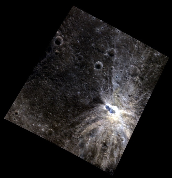
Date acquired: January 03, 2012
Image Mission Elapsed Time (MET): 234069356, 234069376, 234069360
Image ID: 1218103, 1218108, 1218104
Instrument: Wide Angle Camera (WAC) of the Mercury Dual Imaging System (MDIS)
WAC filters: 9, 7, 6 (996, 748, 433 nanometers) in red, green, and blue
Center Latitude: 10.47°
Center Longitude: 113.8° E
Resolution: 466 meters/pixel
Scale: Eminescu has a diameter 130 km (81 mi)
Incidence Angle: 26.6°
Emission Angle: 23.5°
Phase Angle: 50.2°
Of Interest: Centered in this stunning image lies Eminescu crater, illuminated by a bright halo of material around its edge. The ends of a ray system emanating from Xiao Zhao are on the right side of the image. Standing in stark contrast with the low reflectance material within the crater (identifiable as the dark regions on the crater's floor) are bright hollows (identifiable as the bright ring near the crater's center).
Today's image title is in reference to the Cat's Eye Nebula, a well studied, iconic nebula that shares similar features to this image of Eminescu, such as notably the blues, yellows, and spherical shape of the formation.
This image was acquired as a high-resolution targeted color observation. Targeted color observations are images of a small area on Mercury's surface at resolutions higher than the 1-kilometer/pixel 8-color base map. During MESSENGER's one-year primary mission, hundreds of targeted color observations were obtained. During MESSENGER's extended mission, high-resolution targeted color observations are more rare, as the 3-color base map covered Mercury's northern hemisphere with the highest-resolution color images that are possible.
.

Date acquired: November 12, 2011
Image Mission Elapsed Time (MET): 229624183
Image ID: 1005096
Instrument: Narrow Angle Camera (NAC) of the Mercury Dual Imaging System (MDIS)
Center Latitude: 4.40°
Center Longitude: 211.4° E
Resolution: 39 meters/pixel
Scale: Tyagaraja has a diameter of 97 kilometers (60 miles)
Incidence Angle: 9.4°
Emission Angle: 68.8°
Phase Angle: 78.3°
Of Interest: This exciting image, taken at a highly oblique angle, shows the interior of Tyagaraja crater (with north being to the right). Complete with central peaks, extensive hollows, and sloping terraced walls, this view allows us to get a unique perspective into the crater and complements other images by adding a different look at the topography of the surface.
This image was acquired as a high-resolution targeted observation. Targeted observations are images of a small area on Mercury's surface at resolutions much higher than the 200-meter/pixel morphology base map. It is not possible to cover all of Mercury's surface at this high resolution, but typically several areas of high scientific interest are imaged in this mode each week.
.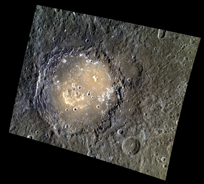
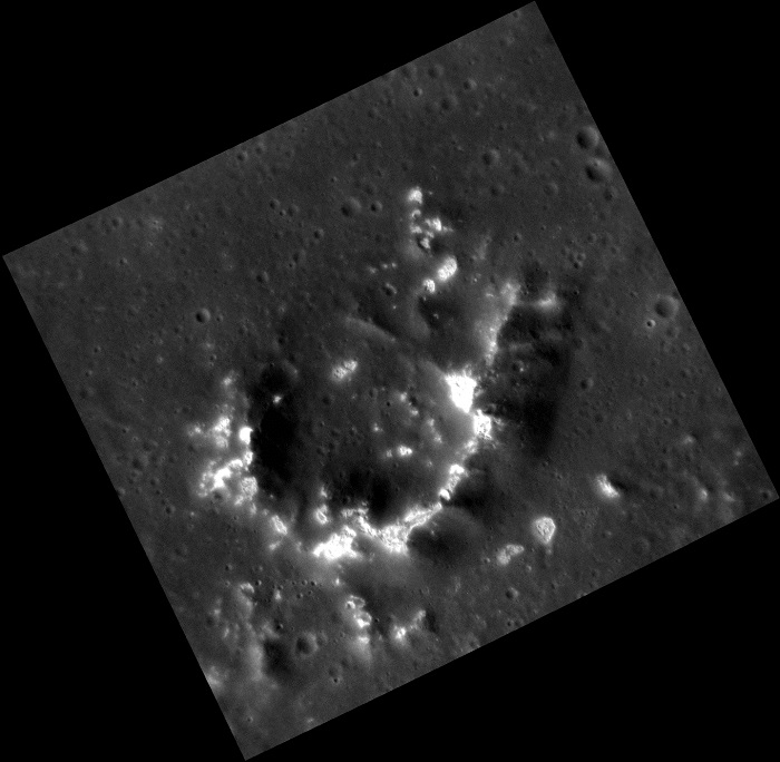
Date acquired: February 12, 2013 Image Mission Elapsed Time (MET): 3010537, 3010557, 3010541 Image ID: 3507773, 3507778, 3507774 Instrument: Wide Angle Camera (WAC) of the Mercury Dual Imaging System (MDIS) WAC filters: 9, 7, 6 (996, 748, 433 nanometers) in red, green, and blue Center Latitude: 15.05° Center Longitude: 312.1° E Resolution: 282 meters/pixel Scale: The larger crater, Lermontov, is 166 km in diameter (103 miles). Incidence Angle: 49.3° Emission Angle: 28.7° Phase Angle: 78.0° Of Interest: The crater Lermontov is named after a 19th century Russian poet, Mikhail Lermontov, who is sometimes called "the poet of the Caucasus." The color variations and irregular depressions suggest that this crater was once home to explosive volcanism. The crater also has small bright "spots" on its floor that are interpreted to be hollows. This image was acquired as a high-resolution targeted color observation. Targeted color observations are images of a small area on Mercury's surface at resolutions higher than the 1-kilometer/pixel 8-color base map. During MESSENGER's one-year primary mission, hundreds of targeted color observations were obtained. During MESSENGER's extended mission, high-resolution targeted color observations are more rare, as the 3-color base map covered Mercury's northern hemisphere with the highest-resolution color images that are possible. The MESSENGER spacecraft is the first ever to orbit the planet Mercury, and the spacecraft's seven scientific instruments and radio science investigation are unraveling the history and evolution of the Solar System's innermost planet. During the first two years of orbital operations, MESSENGER acquired over 150,000 images and extensive other data sets. MESSENGER is capable of continuing orbital operations until early 2015. |
.
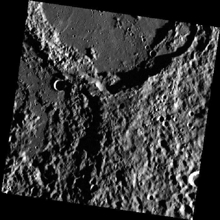
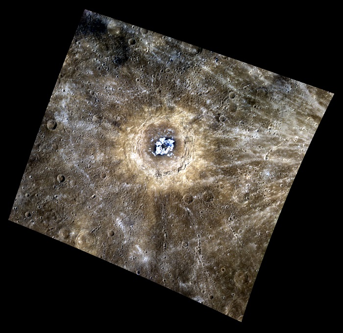
Date acquired: February 10, 2013
Image Mission Elapsed Time (MET): 2778942, 2778934, 2778938
Image ID: 3491366, 3491364, 3491365
Instrument: Wide Angle Camera (WAC) of the Mercury Dual Imaging System (MDIS)
WAC filters: 9, 7, 6 (996, 748, 433 nanometers) in red, green, and blue
Center Latitude: 82.92°
Center Longitude: 286.5° E
Resolution: 86 meters/pixel
Scale: The small crater in the center of the image is 2.7 km (1.7 miles) in diameter.
Incidence Angle: 88.0°
Emission Angle: 17.5°
Phase Angle: 87.8°
Of Interest:
This view shows the edge of the Goethe Basin. The margins of the basin interior are marked by wrinkle ridges. Part of one such ridge is shown in this image. The scene also includes small secondary crater chains on the smooth plains that fill the basin, and the hummocky terrain outside of the basin.
This image was acquired as part of MDIS's high-resolution 3-color imaging campaign. The map produced from this campaign complements the 8-color base map (at an average resolution of 1 km/pixel) acquired during MESSENGER's primary mission by imaging Mercury's surface in a subset of the color filters at the highest resolution possible. The three narrow-band color filters are centered at wavelengths of 430 nm, 750 nm, and 1000 nm, and image resolutions generally range from 100 to 400 meters/pixel in the northern hemisphere
.
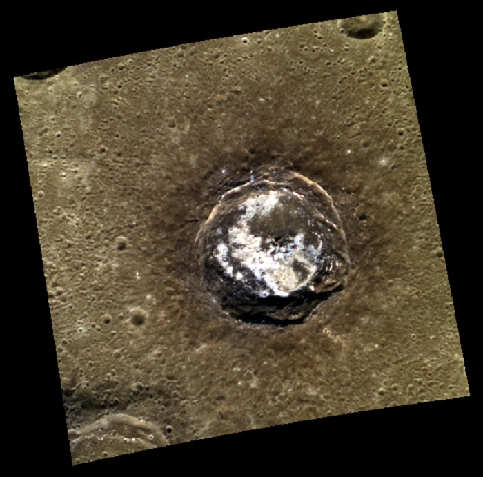
Date acquired: April 18, 2013
Image Mission Elapsed Time (MET): 8569855
Image ID: 3903061
Instrument: Narrow Angle Camera (NAC) of the Mercury Dual Imaging System (MDIS)
Center Latitude: 23.15°
Center Longitude: 256.8° E
Resolution: 34 meters/pixel
Scale: The peak ring is about 18 km in diameter (11 miles).
Incidence Angle: 43.7°
Emission Angle: 20.8°
Phase Angle: 64.6°
Of Interest:
Peak rings within large complex craters are common on Mercury. Here, within Mickiewicz, the lunate central peak ring also contains hollows, which are bright shallow depressions etched into older surfaces.
This image was acquired as a high-resolution targeted observation. Targeted observations are images of a small area on Mercury's surface at resolutions much higher than the 200-meter/pixel morphology base map. It is not possible to cover all of Mercury's surface at this high resolution, but typically several areas of high scientific interest are imaged in this mode each week.
.
Date acquired: August 19, 2011
Image Mission Elapsed Time (MET): 222275999, 222275995, 222275991
Image ID: 652862, 652861, 652860
Instrument: Wide Angle Camera (WAC) of the Mercury Dual Imaging System (MDIS)
WAC filters: 9, 7, 6 (996, 748, 433 nanometers) in red, green, and blue
Center Latitude: 27.84°
Center Longitude: 30.73° E
Resolution: 116 meters/pixel
Scale: The small bright crater measures about 13 km (8 mi.) in long dimension.
Incidence Angle: 31.1°
Emission Angle: 37.2°
Phase Angle: 68.3°
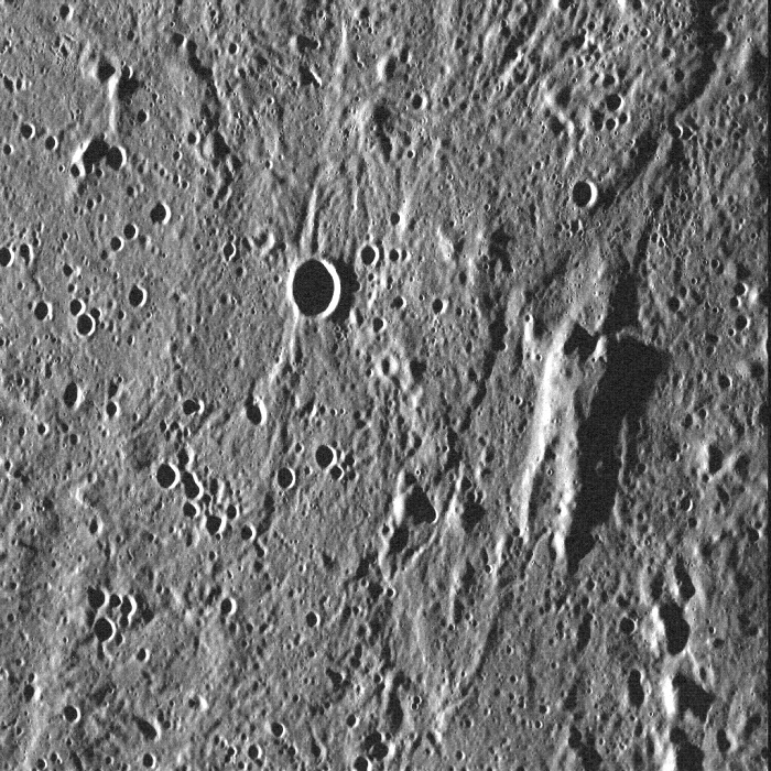
Of Interest: Fresh and bright, this unnamed, elongated crater appears to have been formed by an impactor that struck the surface at an oblique angle, causing most of the ejecta to be thrown out unevenly around the crater (notice the bright rays above, below, and to the right of the crater). The marginally bright material in the bottom left corner is actually part of a ray from Hokusai, over 1380 km (about 860 mi.) away!
The planet Mercury is named after the Roman messenger god (identified with Hermes in Greek mythology). A key feature about the god Mercury is his winged sandals – referenced here in the title of this image. Mercury’s role as the god of communication and messages influenced the acronym for the MESSENGER spacecraft.
.
Date acquired: October 14, 2011
Image Mission Elapsed Time (MET): 227092494
Image ID: 884412
Instrument: Wide Angle Camera (WAC) of the Mercury Dual Imaging System (MDIS)
WAC filter: 7 (748 nanometers)
Center Latitude: 79.09°
Center Longitude: 352.7° E
Resolution: 140 meters/pixel
Scale: The "V" is about 59 km (37 mi.) long
Incidence Angle: 84.1°
Emission Angle: 28.2°
Phase Angle: 112.3°
Of Interest: This view of a location within Mercury's northern volcanic plains includes a set of
wrinkle ridges that form a "V" shape.
This image was acquired as part of MDIS's high-resolution surface morphology base map. The surface morphology base map covers more than 99% of Mercury's surface with an average resolution of 200 meters/pixel. Images acquired for the surface morphology base map typically are obtained at off-vertical Sun angles (i.e., high incidence angles) and have visible shadows so as to reveal clearly the topographic form of geologic features.
.
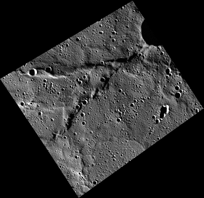
Date acquired: March 04, 2012
Image Mission Elapsed Time (MET): 239375379
Image ID: 1474113
Instrument: Narrow Angle Camera (NAC) of the Mercury Dual Imaging System (MDIS)
Center Latitude: -33.50°
Center Longitude: 280.4° E
Resolution: 180 meters/pixel
Scale: Rude crater is about 67 km (42 mi.) in diameter
Incidence Angle: 81.8°
Emission Angle: 18.4°
Phase Angle: 100.3°
Of Interest: This view from MESSENGER's Narrow Angle Camera shows the impact crater Rude under morning illumination. The crater has small remnant central peaks that are slightly off-center. A sizable impact crater formed on Rude's floor, possibly causing slumping of Rude's northern rim. Francois Rude was a French sculptor who lived from 1784–1855. His "Mercury Fastening his Sandals" is in the Louvre.
This image was acquired as part of MDIS's high-resolution surface morphology base map. The surface morphology base map covers more than 99% of Mercury's surface with an average resolution of 200 meters/pixel. Images acquired for the surface morphology base map typically are obtained at off-vertical Sun angles (i.e., high incidence angles) and have visible shadows so as to reveal clearly the topographic form of geologic features.
.
Date acquired: July 27, 2011
Image Mission Elapsed Time (MET): 220245203
Image ID: 556691
Instrument: Wide Angle Camera (WAC) of the Mercury Dual Imaging System (MDIS)
Center Latitude: 51.9°
Center Longitude: 167.6° E
Resolution: 75 meters/pixel
Scale: This scene is 96 km (59.7 mi.) across
Incidence Angle: 84.5°
Emission Angle: 35.3°
Phase Angle: 119.8°
North is up in this image.
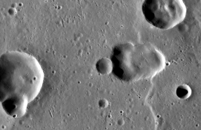
Of Interest: If there are two things you should remember, it's not to cross a Hutt, and that Mercury's surface can throw up all kinds of surprises. In this image, a portion of the terrain surrounding the northern margin of the Caloris basin hosts an elevated block in the shape of a certain carbonite-encased smuggler who can make the Kessel Run in less than twelve parsecs. This block may be part of the original surface that pre-dates the formation of Caloris, which was shaped by material ejected during the basin-forming event. The act of seeing a meaningful shape in random landforms is a form of pareidolia—and has been seen for Mercury more than a few times before...
.
Date acquired: June 30, 2013
Image Mission Elapsed Time (MET): 14936140
Image ID: 4355811
Instrument: Narrow Angle Camera (NAC) of the Mercury Dual Imaging System (MDIS)
Center Latitude: 24.18°
Center Longitude: 148.1° E
Resolution: 48 meters/pixel
Scale: The proposed vent is 17.9 km (11.1 mi.) across
Incidence Angle: 66.0°
Emission Angle: 50.3°
Phase Angle: 115.4°
Of Interest: The Caloris basin contains a complex mix of impact, tectonic, and volcanic features. At center-right, the elongate depression may be a volcanic vent within the basin. This feature highlights the ambiguity that sometimes arises in discerning whether a depression is due to an impact or a volcanic event, as both can leave elongate depressions. One clue that might point to volcanism is the depression's slightly irregular shape; another is the apparent lack of a rim of impact ejecta that is raised above the baseline level of the surrounding terrain.
This image was acquired as a high-resolution targeted observation. Targeted observations are images of a small area on Mercury's surface at resolutions much higher than the 200-meter/pixel morphology base map. It is not possible to cover all of Mercury's surface at this high resolution, but typically several areas of high scientific interest are imaged in this mode each week.
.
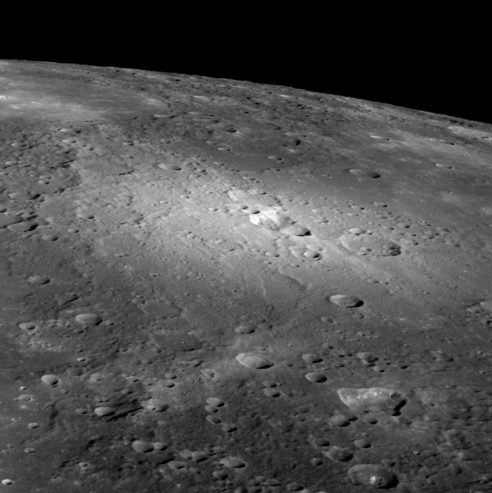
Date acquired: August 14, 2013
Image Mission Elapsed Time (MET): 18791579
Image ID: 4630071
Instrument: Narrow Angle Camera (NAC) of the Mercury Dual Imaging System (MDIS)
Center Latitude: -33.54°
Center Longitude: 77.82° E
Resolution: 104 meters/pixel
Scale: This scene is approximately 106 km (66 mi.) across
Incidence Angle: 79.3°
Emission Angle: 2.8°
Phase Angle: 76.7°
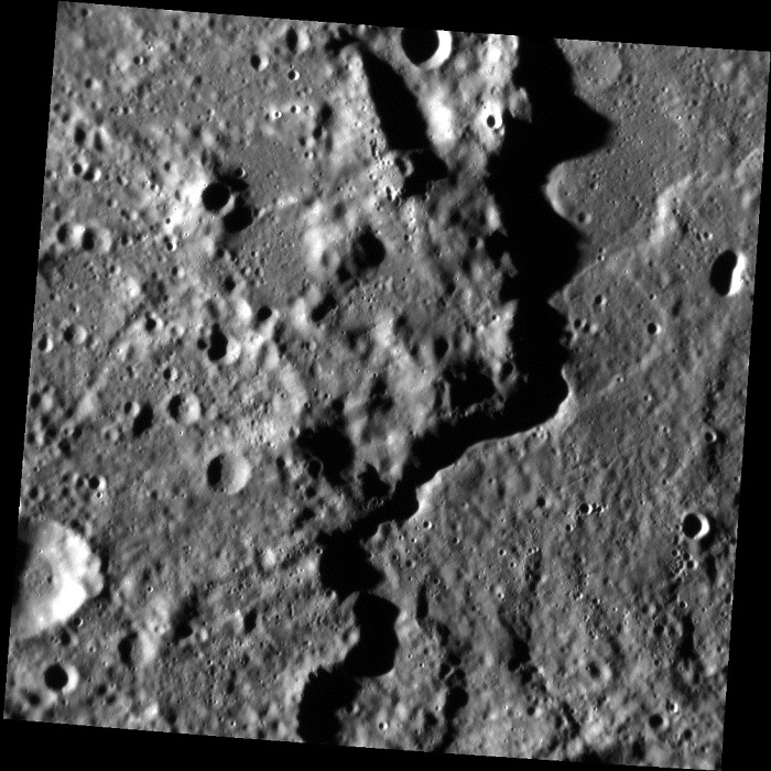
Of Interest: The Rembrandt basin, first discovered during MESSENGER's second flyby of Mercury, is the youngest of the large impact basins that formed on Mercury. Here you can see a portion of the rim. The rim scarp runs north-south along the scene, casting a meandering shadow that separates the basin exterior on the left from the interior on the right. The two sides don't look hugely different, likely because during and after the basin-forming event molten rock coated much of this area, later solidifying to form the surface we see today.
This image was acquired as a targeted set of stereo images. Targeted stereo observations are acquired at resolutions much higher than that of the 200-meter/pixel stereo base map. These targets acquired with the NAC enable the detailed topography of Mercury's surface to be determined for a local area of interest.
.
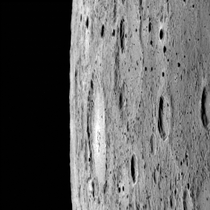
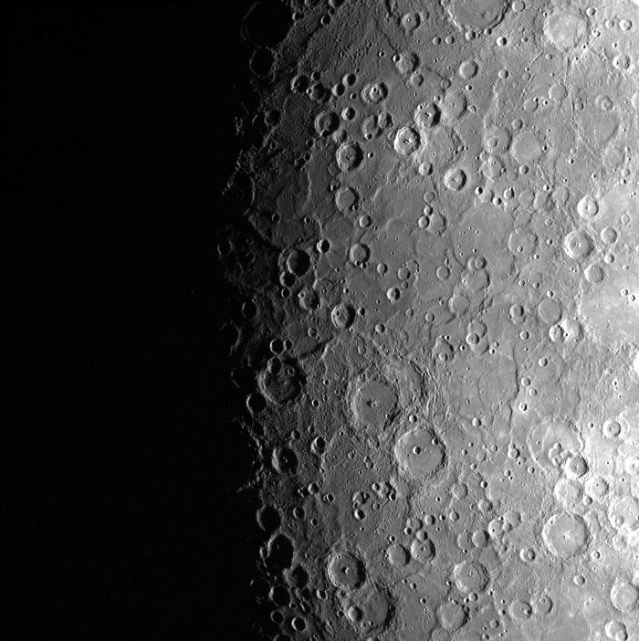
Date acquired: July 16, 2013
Image Mission Elapsed Time (MET): 16312930
Image ID: 4453973
Instrument: Narrow Angle Camera (NAC) of the Mercury Dual Imaging System (MDIS)
Center Latitude: -49.77°
Center Longitude: 352.9° E
Resolution: 183 meters/pixel
Scale: The bright crater at center is approximately 110 km (68 mi.) in diameter
Incidence Angle: 60.7°
Emission Angle: 80.9°
Phase Angle: 141.6°
Of Interest: Looking toward the horizon, you get a sense of what it might be like to ride along with MESSENGER, taking in the view. In this look at the limb, the large crater near the center is approximately 110 km (68 miles) across. Because the angle between the Sun and the spacecraft is large (a phase angle of 141.6°), we see only the shadowed walls of most small craters, giving the surface a speckled appearance.
This image was acquired as part of MDIS's limb imaging campaign. Once per week, MDIS captures images of Mercury's limb, with an emphasis on imaging the southern hemisphere limb. These limb images provide information about Mercury's shape and complement measurements of topography made by the Mercury Laser Altimeter (MLA) of Mercury's northern hemisphere.
.
Date acquired: August 23, 2013
Image Mission Elapsed Time (MET): 19543205
Image ID: 4683301
Instrument: Wide Angle Camera (WAC) of the Mercury Dual Imaging System (MDIS)
WAC filter: 7 (748 nanometers)
Center Latitude: 35.77°
Center Longitude: 63.90° E
Scale: The central vent is approximately 36 km (22 mi.) across
Of Interest: This beautiful view of the volcanic vents located to the north of the Rachmaninoff basin gives a new perspective on the area. At center, a vent is located within the bright pyroclastic deposit that is thought to have erupted front he vent. An older vent is also seen toward the bottom right as an irregularly shaped depression, though it has no clear surrounding deposit. The oblique angle of the image allows a view of the eastern walls of these features.
.
Quelle: NASA