

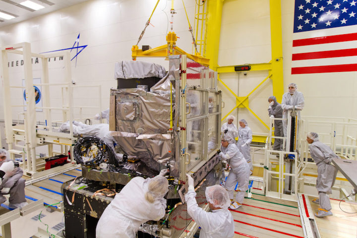
CAPE CANAVERAL — On the cusp of advancing U.S. weather forecasting, a powerful new satellite was shipped from its Denver factory to the Cape today in preparation for launch in November.
The first-of-its-kind observatory dubbed GOES R was flown aboard an Air Force C-5 transport aircraft from Lockheed Martin to the Kennedy Space Center to initiate its launch campaign.
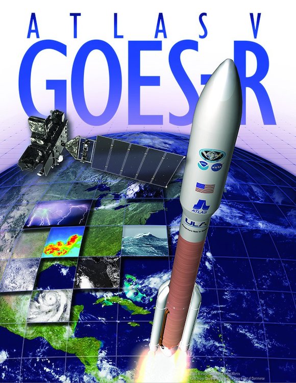
Liftoff aboard a United Launch Alliance Atlas 5 rocket is planned for Nov. 4 at 5:40 p.m. EDT (2140 GMT) from Cape Canaveral’s Complex 41. The daily launch window extends 120 minutes.
The Geostationary Operational Environmental Satellite R will orbit 22,300 miles above the equator in lockstep with the Americas to provide unprecedented new weather-forecast tools.
GOES R, plus three future sister-satellites, is a collaborative project between NASA — which ordered the spacecraft, instruments and launchers — and operator NOAA. Lockheed Martin built the craft.
“It will provide continuous imagery and atmospheric measurements of Earth’s western hemisphere, and also support space weather prediction,” said Sandra Smalley, head of NASA’s Joint Agency Satellite Division.
“It’s the next generation (of GOES satellites) providing a major improvement in quality, quantity and timeliness of the data collected. Overall, it will provide visual and IR imagery, lightning mapping, space weather monitoring and solar imaging. It will accomplish all of this using six instruments.”
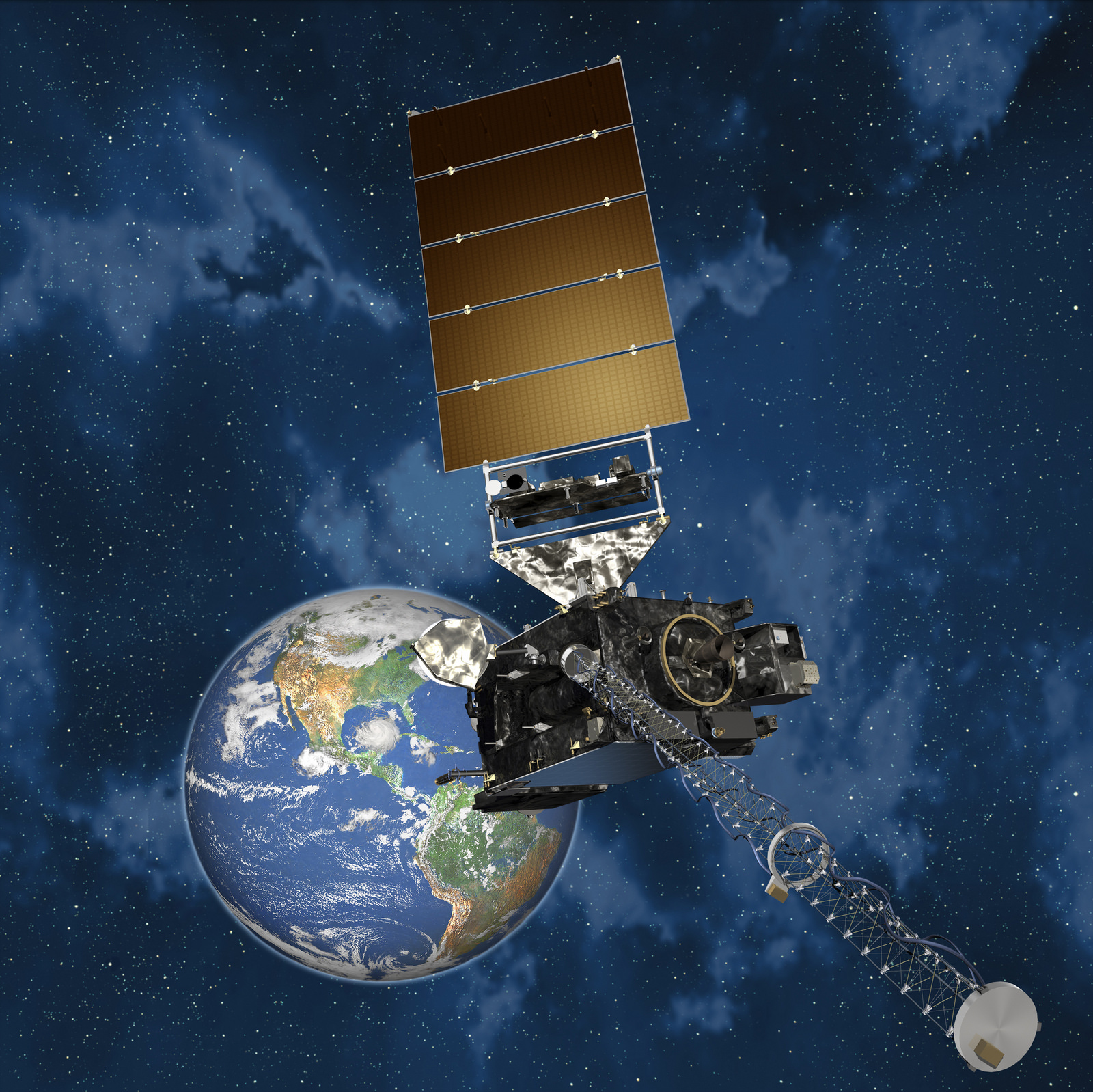
The primary instrument — the Advanced Baseline Imager — will show the motion of clouds and weather systems in visible and infrared bands that television meteorologists use in newscasts. The instrument will monitor water vapor, measure land and sea surface temperature and depict rainfall rates.
It will produce real-time estimates of central pressure and maximum sustained winds for tracking the intensity of hurricanes, and measure the key ingredients of severe weather like winds, cloud growth and lightning to improve tornado warnings.
The ABI will collect three times more data at four times better resolution while providing more than five times faster coverage than current GOES satellites, NOAA says.
GOES R also carries the first Geostationary Lightning Mapper. It will use a high-speed camera to detect in-cloud and cloud-to-ground lightning over the Americas and surrounding ocean areas. GLM promises to increase the warning time for severe weather.
GOES R also has instruments to monitor the Sun, detect solar storm eruptions and alert when the space weather arrives at Earth. Such storms can impact communications, disrupt power grids, threaten the health of astronauts and harm satellites.
The Atlas 5 rockets that will launch GOES R — and GOES S in 2018 — will fly in the 541 configuration with a five-meter fairing, four solid rocket boosters and a single-engine Centaur upper stage.
A three-hour ascent featuring three burns by the Centaur will deliver the craft into a customized high-perigee geosynchronous transfer orbit of 3,600 by 22,000 miles at 12.9 degrees inclination. Five burns of the satellite’s main engine will bring the craft to geostationary orbit within 8 days of launch.
“They are huge satellites. GOES R is getting ready to launch, so it’s fully integrated, and GOES S is well along the way,” said Smalley.
“GOES R has had some technical challenges, so (GOES) S has basically been used as a spares spacecraft for (GOES) R, but they’ve made great progress.”
After touching down at the Shuttle Landing Facility at 3:16 p.m. today, the satellite will be taken to the commercial Astrotech processing facility in Titusville this evening to be unboxed from its shipping container for the start of final testing, fueling and encapsulation.
“This milestone is a great achievement for the entire GOES-R team, who have worked tirelessly to get the spacecraft to Florida,” said Greg Mandt, NOAA’s GOES R system program director. “Moving forward, we are focused on preparing this highly advanced weather satellite for its historic launch in just a few short months.”
GOES R will be renamed GOES 16 once it reaches geostationary orbit. Initially, controllers position the satellite at 89.5 degrees West longitude for an extensive year-long checkout and validation. It then awaits call-up to replace either the GOES West or GOES East operational observatories covering the U.S.
The GOES program dates back to 1975. Unlike today’s three-axis stabilized satellites, the first GOES were spin-stabilized and viewed Earth only about ten percent of the time.

The GOES R, S, T and U series is expected to sequentially extend geostationary weather satellite operations to 2036. Each satellite is capable of five years in-space storage and 10 years of use.
GOES T launches in 2019 and GOES U follows in 2024. Launch vehicles have not yet been assigned to those two spacecraft.
Currently, GOES 15 is the GOES West satellite at 135 degrees West longitude. It was launched as GOES P atop a Delta 4 rocket in 2010. GOES 13 — launched as GOES N in 2006 — is the GOES East satellite at 75 degrees West. The GOES 14 launched in 2009 as GOES O serves as the in-space spare, ready to be pressed into service at a moment’s notice.
Quelle: SN
-
Next-Generation Geostationary Satellite Being Readied for November Launch
 Lockheed Martin delivered NOAA’s GOES-R weather satellite to its Florida launch site on Aug. 22, 2016. The spacecraft was shipped aboard a U.S. Air Force C-5M Super Galaxy cargo plane from Buckley Air Force Base, Colorado to NASA’s Kennedy Space Center, Florida. The satellite will now undergo final processing in preparation for a November launch.
DENVER, Aug. 23, 2016 – NOAA’s newest weather satellite, GOES-R, left its Colorado home where it was built and is now in Florida where it will undergo preparations for a Nov. 4 launch. Monday, Lockheed Martin (NYSE: LMT) shipped the next-generation satellite aboard an Air Force C-5M Super Galaxy cargo transport plane to its Astrotech Space Operations facility in Titusville, Florida.
The first of four next-generation geostationary weather satellites, the Geostationary Operational Environmental Satellite R-Series, or GOES-R, will provide a major improvement in quality, quantity and timeliness of weather data collected over the current GOES satellite system that monitors weather over North America.
“Our team understands the important mission of this national asset, and delivering it to the launch site moves it one step closer to providing an upgraded capability for NOAA and our nation,” said Tim Gasparrini, vice president and GOES-R Series program manager at Lockheed Martin Space Systems. “This is an exciting time for everyone on the GOES-R program and we’re focused on the work ahead of us here in Florida, performing the final tests and readying the satellite for a successful launch.”
Lockheed Martin designed, built and tested the satellite and is responsible for spacecraft launch processing. GOES-R will launch aboard a United Launch Alliance Atlas V 541 rocket from Cape Canaveral Air Force Station in Florida. In addition to the four GOES-R Series satellites (R, S, T and U), Lockheed Martin also designed and built the Solar Ultraviolet Imager (SUVI) and the Geostationary Lightning Mapper (GLM) instruments that will fly aboard each spacecraft.

GOES-R’s data will support short-term weather forecasts and severe storm warnings, maritime forecasts, seasonal predictions, drought outlooks and space weather predictions. Additionally, GOES-R products will improve hurricane tracking and intensity forecasts, and increase thunderstorm and tornado warning lead time.
NOAA funds, manages, and will operate the GOES-R Series satellites. NASA oversees the acquisition and development of the GOES-R spacecraft and instruments for NOAA. The program is co-located at NASA’s Goddard Space Flight Center in Greenbelt, Maryland.
About Lockheed Martin
Headquartered in Bethesda, Maryland, Lockheed Martin is a global security and aerospace company that employs approximately 98,000 people worldwide and is principally engaged in the research, design, development, manufacture, integration and sustainment of advanced technology systems, products and services.
Quelle: Lockheed Martin
-
Update: 27.08.2016
.

Media accreditation now is open for the launch of NOAA’s Geostationary Operational Environmental Satellite-R (GOES-R) weather and environmental satellite, currently planned for Nov. 4.
GOES-R will launch aboard a United Launch Alliance Atlas V rocket from Space Launch Complex 41 at Cape Canaveral Air Force Station in Florida. The two-hour launch window opens at 5:40 p.m. EDT.
Media prelaunch and launch activities will take place at Cape Canaveral and NASA’s Kennedy Space Center, adjacent to Cape Canaveral. Credentialing deadlines are as follows:
- International media without U.S. citizenship must apply by 4:30 p.m. Friday, Sept. 30, for access to Cape Canaveral and Kennedy.
- International media without U.S. citizenship must apply by 4:30 p.m. Wednesday, Oct. 19, for access only to Kennedy.
- U.S. media must apply by 4:30 p.m. Tuesday, Oct. 25.
All media accreditation requests should be submitted online at:
International media are required to upload a scanned copy of their I (media) visa and passport or green card with their accreditation requests. Media must present two forms of unexpired, government identification to enter Kennedy. One form must include a photo, such as a passport or driver’s license.
Questions about accreditation may be addressed to Jennifer Horner at jennifer.p.horner@nasa.govor 321-867-6598. For other questions, or additional information, contact Kennedy’s newsroom at 321-867-2468.
GOES-R is the first of four satellites to be launched for NOAA in a new and advanced series of spacecraft. Once in geostationary orbit, it will be known as GOES-16 and will provide images of weather patterns and severe storms across the continental U.S. as regularly as every five minutes, with smaller, more detailed images of areas where storm activity is present as frequently as every 30 seconds. These images can be used to aid in formulating regular forecasts, severe weather outlooks, and watches and warnings, assessing lightning conditions, and improving maritime and aviation forecasts. It also will assist in long-term forecasting, such as seasonal predictions and drought outlooks. In addition, the satellite constantly will monitor space weather conditions, such as solar flares, to provide advance notice of potential communication and navigation disruptions. The satellite also will assist researchers in understanding the interactions between land, oceans, the atmosphere and climate.
Quelle: NASA
-
Update: 28.10.2016
.
NOAA’s new satellite will finally pull weather forecasting technology out of the 1980s
Two Colorado companies are working together on the first major upgrade to the U.S. government’s weather observation instruments since the 1980s – and that means the forecast on your phone might get more accurate in the years ahead.
“It’s pretty much been black and white images of clouds since the 1970s,” said Greg Mandt, National Oceanic and Atmospheric Administration (NOAA) GOES-R Program Director. A series of space missions will bring a change as dramatic as the jump from black-and-white to HD television.
It starts this November, when Littleton-based Lockheed Martin launches a billion-dollar weather satellite aboard a United Launch Alliance rocket in mid-November.
Known as the Geostationary Operational Environmental Satellite-R (GOES-R), it’s the first of four spacecraft designed to sustain U.S. weather forecasting through the year 2030.
The new satellite carries six instruments that will help with short-term weather forecasting, seasonal predictions, severe weather watches, oceanic forecasts, drought predictions and space weather. The updated technology will help with hurricane, thunderstorm and tornado tracking and improvements to
“The instruments onboard GOES-R are the first upgrades to the GOES system since the 1980s, providing higher-resolution images of weather patterns and severe storms five times faster than today,” Tim Gasparrini, vice president and GOES-R Series program manager at Lockheed Martin said in a statement.
Previous satellite updates have been very minor, such as tweaking sensitivity and resolution or adding additional channels, Mandt explained
The new GOES-R imager will have three times the amount of channels, four times the resolution and will scan five times faster. That means that NOAA will be able to see the entire hemisphere in about five minutes, as opposed to the thirty minutes it takes today–in high resolution and full color.
Lockheed beat out Boeing in 2008 for the first $1.09 billion contract, then was later tapped by NASA and the National Oceanic and Atmospheric Administration (NOAA) to build the follow-up satellites, GOES-S, T and U, Space News reported.
How will this affect your life?
Government weather satellites, especially GOES, provide much of the data that filters down to commercial services, which means that forecasters of all sorts will be working with better information.
The most noticeable change will be in severe weather monitoring. Higher speeds and resolution mean forecasters can zoom in on storms, a tornado or lightning field, for example, and check-in every 30 seconds.
Additionally, they will be able to provide longer lead times before the storm hits, as well as more precise storm locating, so people can take action to get out of harm’s way.
If you want to learn more about GOES-R forecasting, watch this creepy cute video by NOAA:
After NASA’s shuttle program ended in 2011, Space Florida, the agency responsible for growing the state’s space industry, decided to refocus its efforts on bringing more commercial spaceflight to the area, Orlando Business Journal reported.
Today about 75 percent of the the $300 billion industry comes from commercial space programs like that of United Launch Alliance and SpaceX, and the Space Coast sees more launches than it has since the 1960s.
The GOES-R satellite was transported to Cape Canaveral in August and will launch Nov. 16 between 2:42 and 4:42 p.m. mountain time aboard United Launch Alliance’s Atlas V rocket.
Quelle: Denverite
-
Update: 31.10.2016
.

The first spacecraft in a new series of NASA-built advanced geostationary weather satellites is set to launch into orbit aboard a United Launch Alliance Atlas V rocket Wednesday, Nov. 16. The two-hour launch window opens at 4:42 p.m. EST. Liftoff will occur from Space Launch Complex 41 at Cape Canaveral Air Force Station in Florida.
News briefings, live launch commentary, photo opportunities and other media events will be held at nearby NASA Kennedy Space Center, and carried live on NASA Television and the agency’s website.
Once in geostationary orbit, GOES-R will be known as GOES-16 and will provide images of weather patterns and severe storms as regularly as every five minutes or as frequently as every 30 seconds. These images can be used to aid in weather forecasts, severe weather outlooks, watches and warnings, lightning conditions, maritime forecasts and aviation forecasts. It also will assist in longer term forecasting, such as in seasonal predictions and drought outlooks. In addition, space weather conditions will be monitored constantly, including the effects of solar flares to provide advance notice of potential communication and navigation disruptions. It also will assist researchers in understanding the interactions between land, oceans, the atmosphere and climate.
NASA TV Events Schedule
For all media briefings, reporters may ask questions by calling the Kennedy newsroom at 321-867-2468 no later than 15 minutes before briefings begin. Media also can ask questions via Twitter by using the hashtag #askNASA. All times are Eastern.
Monday, Nov. 14
1 p.m. – Prelaunch news conference at Kennedy’s Press Site
Briefing participants are:
- Stephen Volz, assistant administrator for satellite and information services, National Oceanic and Atmospheric Administration (NOAA)
- Sandra Smalley, director, Joint Agency Satellite Division, NASA Headquarters
- Omar Baez, launch director, NASA Kennedy
- Scott Messer, program manager, NASA Missions, United Launch Alliance
- Greg Mandt, GOES-R system program director, NOAA
- Clay Flinn, launch weather officer, 45th Weather Squadron, Cape Canaveral Air Force Station
2 p.m. – GOES-R Mission Briefing
Briefing participants include:
- Steven Goodman, GOES-R program scientist, NOAA
- Laura Furgione, deputy director, National Weather Service
- Sandra Cauffman, deputy director, Earth Science Division, NASA Headquarters
Tuesday, Nov. 15
1 p.m. – GOES-R NASA Social presentations
Wednesday, Nov. 16
3 p.m. – Prelaunch program by NASA EDGE
4 p.m. -- Launch coverage and commentary begins
The United Launch Alliance Atlas V first stage is lifted to the vertical position at the Vertical Integration Facility at Space Launch Complex 41 at Cape Canaveral Air Force Station in Florida. The Geostationary Operational Environmental Satellite (GOES-R) will launch aboard the Atlas V rocket in November. GOES-R will be the first satellite in a series of next-generation NOAA GOES Satellites. Photo credit: NASA/Kim Shiflett
Quelle: NASA
-
Update: 4.11.2016
.
Atlas V to Launch GOES-R
Rocket/Payload: A United Launch Alliance Atlas V 541 configuration rocket will launch the Geostationary Operational Environmental Satellite-R (GOES-R) mission for the National Oceanic and Atmospheric Administration and NASA.
Date/Site/Launch Time: Saturday, Nov. 19, 2016, from Space Launch Complex (SLC)-41 at Cape Canaveral Air Force Station, Florida. The two-hour launch window opens at 4:42 p.m. EST.
Launch Notes: ULA and our heritage rockets have launched all of the operational GOES satellites. GOES-R marks the fourth Atlas V to launch in the 541 configuration, the first of which was the rocket that launched NASA’s Curiosity rover to Mars in 2011.
Mission Description: GOES-R is the first of four satellites to be launched for NOAA in a new and advanced series of spacecraft. Once in geostationary orbit, it will be known as GOES-16. Compared with today’s geostationary satellites, GOES-R will scan the Earth five times faster at four times image resolution and triple the number of channels scientists can tap into to observe global weather and climate. GOES-R will support short-term forecasts and severe storm watches and warnings, maritime forecasts, seasonal predictions, drought outlooks and space weather predictions. The satellite also will improve hurricane tracking and intensity forecasts, increase thunderstorm and tornado warning lead time, improve aviation flight route planning, and provide data for long-term climate variability studies.
In addition to weather forecasting, GOES-R carries a transponder to detect distress signals from emergency beacons on aircraft, boats/ships and carried by individuals as part of the Search and Rescue Satellite Aided Tracking (SARSAT) system.
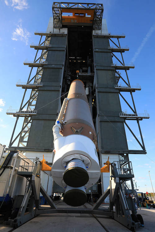
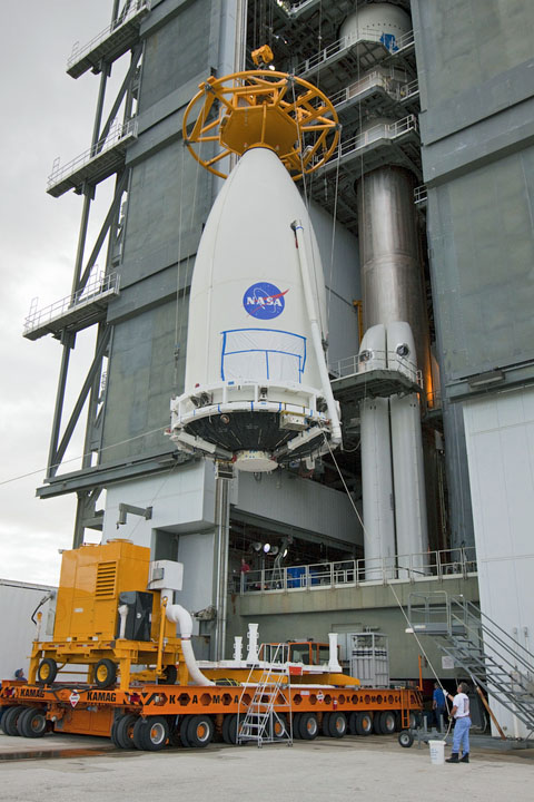
A next-generation national weather satellite on Wednesday morning was placed atop an Atlas V rocket in preparation for a Nov. 19 blastoff from Cape Canaveral Air Force Station.
Starting around 2 a.m., teams rolled the National Oceanic and Atmospheric Administration's GOES-R satellite from a Titusville processing facility to Launch Complex 41.
By 9 a.m., the 6,300-pound spacecraft built by Lockheed Martin, and featuring an imaging instrument from Harris Corp., was hoisted onto the United Launch Alliance rocket inside the Vertical Integration Facility.
Liftoff is targeted for 5:42 p.m. on Saturday, Nov. 19, at the opening of a one-hour window.
GOES-R is the first in NOAA's new series of Geostationary Operational Environmental Satellites, which fly in orbits 22,300 miles over the equator. Matching the speed of Earth's rotation, they appear to stay in fixed positions in the sky.
The nearly $11 billion program includes four spacecraft, new ground stations and related software for processing and distributing forecasting information with four times higher resolution at speeds five times faster than existing systems.
Quelle: Florida Today
----
Advanced weather bird mounted atop Atlas 5 rocket for launch into space
CAPE CANAVERAL — The opening volley in the transformation of U.S. weather forecasting was mounted atop its ride to space today for the planned Nov. 19 launch that begins an $11 billion upgrade in the nation’s meteorology capability.
The Geostationary Operational Environmental Satellite-R, or GOES-R, was hoisted high atop its United Launch Alliance Atlas 5 rocket this morning at the vehicle’s Cape Canaveral vertical assembly building.
At 11,500 pounds and equipped with advanced sensors, it is the heaviest and most sophisticated U.S. weather satellite in history, continuing a line of 16 previous GOES craft launched since 1975.
“Space-based lightning detection and advanced imagery are among the new tools, which will help forecasters better monitor storm development and deliver more precise, timely and accurate watches and warnings,” said NOAA’s National Weather Service director Louis Uccellini.
“With GOES-R, the National Weather Service will have unprecedented new capabilities that allow for a wide range of forecast improvements.”
The heart of the spacecraft is the new imager that will produce substantially more embedded data on clouds and storms at higher resolution in faster refresh times than ever before. Hurricanes, for example, will be tracked at 30-second intervals.
The craft also features the first-of-its-kind lightning mapper that will help in forecasting the intensity of storms, taking 200 images per second to observe cloud-to-cloud and cloud-to-ground strikes.
“NOAA will now operate the most sophisticated technology ever flown in space to help forecast weather on Earth,” said Stephen Volz, assistant NOAA administrator for its Satellite and Information Service.
Lockheed Martin built the GOES-R satellite, which is the first in a series of four observatories that will ensure U.S. weather monitoring into the 2030s.
Getting the GOES-R craft 22,300 miles above the Earth to begin its mission starts with liftoff atop the Atlas 5 rocket on Nov. 19. A one-hour launch window at Cape Canaveral opens at 5:42 p.m. EST (2242 GMT).
Should the liftoff slip to Nov. 20 for some reason, a one-hour window opening at 4:42 p.m. EST (2142 GMT) will be available. The window shortening is due to the FAA’s Holiday Airspace Release Program constraints.
Fitted with four strap-on solid rocket boosters for added power, the rocket will perform a series of complex maneuvers to deliver the satellite into a customized high-perigee, lower-inclination geosynchronous transfer orbit dropoff point three-and-a-half hours after launch.

Once at its destination in geostationary orbit within two weeks, at the altitude that matches Earth’s rotation to stay in continuous lockstep with the Western Hemisphere, the satellite will begin a year-long checkout and demonstration of its new capabilities.
Assembly of the Atlas 5 rocket began on Monday, Oct. 24 by erecting the first stage on its mobile launch platform. The rest of the week was spent attaching the solid-fuel boosters.
The Centaur upper stage, which will fire three separate times during launch to shape the payload’s orbit, was installed on Monday, Oct. 31.
Following initial testing last week, approval was given to bring the encapsulated satellite to Cape Canaveral’s Vertical Integration Facility from the commercial Astrotech payload processing facility in nearby Titusville early this morning.
An overhead, heavy-duty crane lifted the craft through the doorway and positioned it atop the Centaur for mating.
The completed rocket, standing 197 feet tall, will be moved to the Complex 41 launch pad the morning of Friday, Nov. 18 to begin final pre-flight preparations. The RP-1 kerosene fuel gets loaded into the first stage that afternoon.
The launch countdown on Nov. 19 will last about seven hours, with cryogenic fueling operations starting about two hours before liftoff.
NASA’s Launch Services Program is managing the launch, and the space agency was responsible for the design and construction of the GOES-R satellite series through its partnership with NOAA.
It will be the 67th Atlas 5 rocket flight and the milestone-achieving 100th for an Evolved Expendable Launch Vehicle. The nation created the EELV program to carry out critical launches like GOES-R.
“This remarkable spacecraft and the instruments it holds embody what NOAA and the aviation, aerospace, and private weather enterprises have been conceptualizing for years,” said NOAA Administrator Kathryn Sullivan, a former astronaut and first American woman to walk in space.
“GOES-R will serve as the vital foundation for the Weather-Ready Nation we are building. Not only will its data help forecasters increase our watch and warning times, but will help our communities and businesses build smarter, stay safer, and remain resilient to global change.”
Quelle: SN
-
Update: 11.11.2016
.
Ready for launch: Instrument suite to assess space weather

An illustration of a GOES-R spacecraft.
A multimillion dollar CU Boulder instrument package expected to help scientists better understand potentially damaging space weather is now slated to launch aboard a National Oceanic and Atmospheric Administration satellite on Saturday, Nov. 19.
Designed and built by CU Boulder’s Laboratory for Atmospheric and Space Physics (LASP), the instrument suite known as the Extreme Ultraviolet and X-ray Irradiance Sensors (EXIS) is the first of four identical packages that will fly on four NOAA weather satellites in the coming decade. EXIS will measure energy output from the sun that can affect satellite operations, telecommunications, GPS navigation and power grids on Earth as part of NOAA’s next-generation Geostationary Operational Environmental Satellites-R Series (GOES-R).
“We are ready for launch and are looking forward to a successful mission,” said LASP Senior Research Scientist Frank Eparvier, principal investigator on the EXIS project. “These extremely sensitive instruments will help scientists better understand solar events and help to mitigate the effects of space weather on Earth.”
NASA’s contract with CU Boulder on behalf of NOAA to design, build, test, deliver and scientifically support the four instrument packages is for roughly $105 million. The GOES-R satellite was built by Lockheed Martin Space Systems Co. in Littleton, Colorado and will be launched on an Atlas V rocket built by United Launch Alliance, headquartered in Centennial, Colorado.
EXIS consists of two LASP instruments, including XRS, an X-ray sensor that can determine the strength of solar flares and provide rapid alerts to scientists, said Eparvier. Large solar flares, equivalent to the explosion of millions of atomic bombs, can trigger “proton events” that send charged atomic particles flying off the sun and into Earth’s atmosphere in just minutes. They can damage satellites, trigger radio blackouts and even threaten the health of astronauts by penetrating spacecraft shielding, he said.
“The XRS gives the first alert that a solar flare is occurring, providing NOAA with details on its timing, magnitude and direction within seconds,” said Eparvier.
The second EXIS instrument, EUVS, will monitor solar output in the extreme ultraviolet portion of the electromagnetic spectrum, which is completely absorbed by Earth’s upper atmosphere, said Eparvier. When the extreme UV light wavelengths penetrate the upper atmosphere during active periods on the sun, they can break apart, ionize and change the properties of the atmosphere through which satellites fly and radio waves propagate.
Fluctuations in extreme UV wavelengths from the sun ionize the upper atmosphere and interfere with communications like cell phones and GPS signals, said Eparvier. In addition, such fluctuations can create satellite drag, causing spacecraft to slowly fall out of orbit and burn up months or years before such events are anticipated.
“Modern technology has made us vulnerable to extreme variations in space weather that can have significant effects on Earth communications,” Eparvier said. “Extreme solar activity can cause problems for power companies all around the world, for example, in part because they all are interconnected.”
NOAA’s GOES satellites are a series of weather satellites that help scientists make timely and accurate weather forecasts. Two GOES satellites are now in geostationary orbit at a height of about 22,000 miles, with one focusing on the east part of the Americas overlapping with another focusing on the west. Satellites in geostationary orbits complete one revolution in the same amount of time it takes for the Earth to rotate once on its polar axis, allowing them to “stare” at a portion of Earth, said Eparvier.
LASP also built key solar instruments for NASA’s Van Allen Probes mission launched in 2012 to study Earth’s radiation belts, and designed and built a $32 million instrument package for NASA’s Solar Dynamics Observatory that launched in 2010.
More than 100 LASP personnel ranging from scientists and engineers to technicians, programmers and students have worked on the EXIS program since 2006. CU Boulder’s LASP will support EXIS on the four NOAA GOES satellite missions through spacecraft integration, testing, launch and commissioning, said Eparvier.
Each instrument package, roughly the size of a large microwave oven and weighing 66 pounds, is three times heavier than normal due to extra shielding that protects them from high-energy particle penetration. LASP’s Mike Anfinson is the EXIS project manager.
Quelle: University of Colorado
-