
28.12.2021
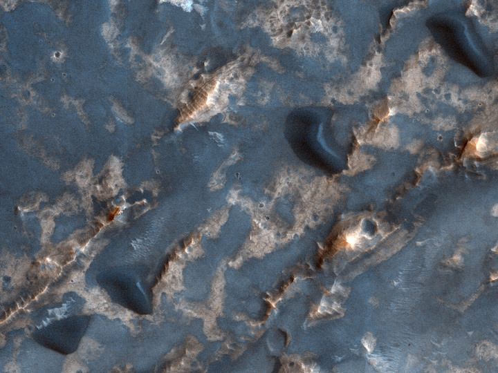
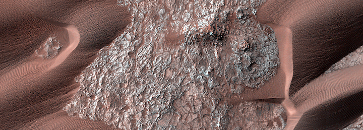
Sometimes, we acquire an image for the simple reason of getting either more coverage of an area, and/or to complete a mosaic of a particular spot. Such is the case for this observation near the center of a massive, eroded and unnamed impact crater in Arabia Terra. It’s located to the west of the much larger Cassini and Pasteur craters.
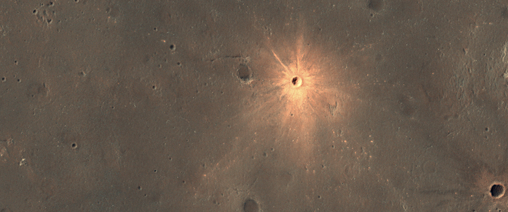
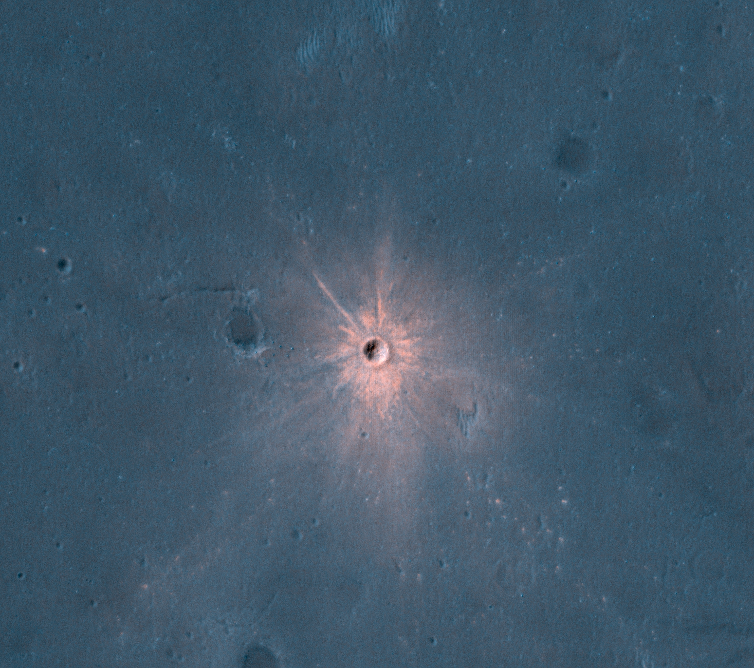
A New Impact Crater with Bright Ejecta
The Context Camera onboard MRO has been discovering new impact sites on Mars, followed up with HiRISE images. Usually these sites are discovered as new dark spots from removal or disturbance of bright dust, but a few show up as new bright spots.
These craters may have bright ejecta from exposure of shallow subsurface materials, below a thin dark cover. An alternate theory—that this is a particle size effect—is unlikely because the bright materials are also distinctly redder than surrounding areas, and because ejecta is typically more coarse-grained, which would make the surface darker rather than brighter.
The new crater visible here is about 13 meters in diameter. The color has been enhanced for this cutout.
Boundary Condition Controls on the High-Sand-Flux Regions of Mars
Abstract
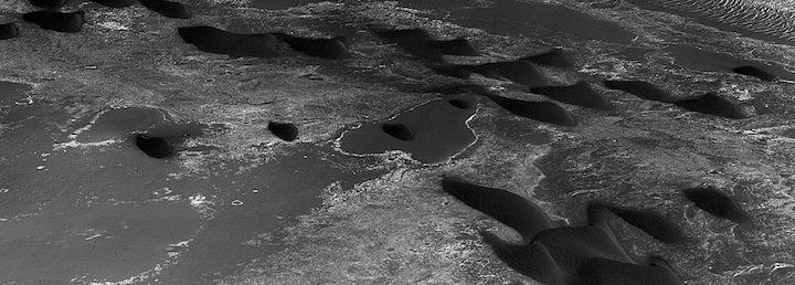
Wind has been an enduring geologic agent throughout the history of Mars, but it is often unclear where and why sediment is mobile in the current epoch. We investigated whether eolian bed-form (dune and ripple) transport rates are depressed or enhanced in some areas by local or regional boundary conditions (e.g., topography, sand supply/availability).
Spectral evidence for hydrated salts in recurring slope lineae on Mars
Abstract
Determining whether liquid water exists on the Martian surface is central to understanding the hydrologic cycle and potential for extant life on Mars. Recurring slope lineae, narrow streaks of low reflectance compared to the surrounding terrain, appear and grow incrementally in the downslope direction during warm seasons when temperatures reach about 250–300K, a pattern consistent with the transient flow of a volatile species. Brine flows (or seeps) have been proposed to explain the formation of recurring slope lineae, yet no direct evidence for either liquid water or hydrated salts has been found4. Here we analyze spectral data from the Compact Reconnaissance Imaging Spectrometer for Mars instrument onboard the Mars Reconnaissance Orbiter from four different locations where recurring slope lineae are present. We find evidence for hydrated salts at all four locations in the seasons when recurring slope lineae are most extensive, which suggests that the source of hydration is recurring slope lineae activity. The hydrated salts most consistent with the spectral absorption features we detect are magnesium perchlorate, magnesium chlorate and sodium perchlorate. Our findings strongly support the hypothesis that recurring slope lineae form as a result of contemporary water activity on Mars.
Persistent Aeolian Activity at Endeavour Crater, Meridiani Planum, Mars: New Observations from Orbit and the Surface
Abstract
Aeolian-driven bedform activity is now known to occur in many regions of Mars, based on surface and orbital observation of contemporary martian ripple and dune mobility events. Many of these sites have only been monitored with sufficient resolution data for the last few Mars years, when the High Resolution Imaging Science Experiment (HiRISE) began acquiring images of Mars. One exception is the well-monitored Endeavour crater in Meridiani Planum, which was one of the first known sites of unambiguous dune activity (migration and deflation). However, those early detections used lower resolution data over longer temporal baselines (versus the HIRISE imagery now available), leaving some measurements poorly constrained. New orbital and surface observations of Endeavour show multiple spatial (cm, m, km) and temporal (seasons, Mars Year) scales of aeolian-driven surface change, which confirms earlier reports. Dome dunes in the eastern portion of the crater persistently deflate, disseminating dark sand across lighter-toned regolith and/or eroded bright dust, and likely also contribute to the crater interior’s episodic decreases in orbital albedo measurements. Other dome dunes are detected with the highest migration rates (4-12 m per Mars year) and volumetric sand fluxes reported yet for Mars. Estimated dune construction times or “turnover times” here and elsewhere on Mars are significantly shorter than martian obliquity cycles, implying that it is not necessary to invoke paleoclimate wind regimes to explain current dune morphologies. Located on the crater rim, the Opportunity rover detected evidence for near- and far-field aeolian-driven activity, with observations of spherules/sand movement in the rover workspace, bedform albedo alteration, and dust-lifting events. Observations of intracrater dunes show periodic shifting dark streaks that significantly constrain local wind regimes (directionality and seasonality). Constraints on wind directions from surface and orbital images show that aeolian bedforms can be extremely active in bi-, and possibly tri-, modal wind regimes, and during periods without major dust storms. 
+++
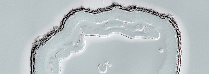
Transient Bright “Halos” on the South Polar Residual Cap of Mars: Implications for Mass-Balance
Abstract
Spacecraft imaging of Mars’ south polar region during mid-southern summer of Mars Year 28 (2007) observed bright halo-like features surrounding many of the pits, scarps and slopes of the heavily eroded carbon dioxide ice of the South Polar Residual Cap (SPRC). These features had not been observed before, and have not been observed since. We report on the results of an observational study of these features, and spectral modeling of the SPRC surface at the time of their appearance. Image analysis was performed using data from MRO’s Context Camera (CTX), and High Resolution Imaging Science Experiment (HiRISE), as well as images from Mars Global Surveyor’s (MGS) Mars Orbiter Camera (MOC). Data from MRO’s Compact Reconnaissance Imaging Spectrometer for Mars (CRISM) were used for the spectral analysis of the SPRC ice at the time of the halos. These data were compared with a Hapke reflectance model of the surface to constrain the formation mechanism of these features. We find that the unique appearance of these features is intimately linked to a near-perihelion global dust storm that occurred shortly before the halos were observed. The combination of vigorous summertime sublimation of carbon dioxide ice from sloped surfaces on the SPRC and simultaneous settling of dust from the global storm, resulted in a sublimation wind that deflected settling dust particles away from the edges of these slopes, keeping these areas relatively free of dust compared to the rest of the cap. The fact that the halos were not exhumed in subsequent years indicates a positive mass-balance for flat portions of the SPRC in those years. A net accumulation mass-balance on flat surfaces of the SPRC is required to preserve the cap, as it is constantly being eroded by the expansion of the pits and scarps that populate its surface.

Valles Marineris Dune Sediment Provenance and Pathways
Abstract
Although low-albedo sand is a prevalent component of the martian surface, sources and pathways of the sands are uncertain. As one of the principal present-day martian sediment sinks, the Valles Marineris (VM) rift system hosts a diversity of dune field populations associated with a variety of landforms that serve as potential sediment sources, including spur-and-gully walls, interior layered deposits (ILDs), and landslides. Here, we test the hypothesis that VM dune fields are largely derived from a variety of local and regional (intra-rift) sediment sources. Results show several dune fields are superposed on ancient wall massifs and ILDs that are topographically isolated from extra-rift sand sources. Spectral analysis of dune sand reveals compositional heterogeneity at the basinal-, dune field-, and dune-scales, arguing for discrete, relatively unmixed sediment sources. In Coprates and Melas chasmata, mapping is consistent with the principle sand source for dunes being Noachian-aged upper and lower wall materials composed of primary (igneous) minerals and glasses, some of which show evidence for alteration. In contrast, dune fields in Capri, Juventae, and Ganges chasmata show evidence for partial sediment derivation from adjacent Early Hesperian-aged hydrated sulfate-bearing ILD units. This finding indicates that these ILDs act as secondary sand sources. Dunes containing “soft” secondary minerals (e.g., monohydrated sulfate) are unlikely to have been derived from distant sources due to the physical weathering of sand grains during transport. Isolated extra-rift dune fields, sand sheets, and sand patches are located on the plateaus surrounding VM and the adjoining areas, but do not form interconnected networks of sand pathways into the rift. If past wind regimes (with respect to directionality and seasonality) were consistent with more recent regimes inferred from morphological analysis (i.e., dune slip faces, wind streaks), and were sufficient in strength and duration, small dune populations within Aurorae Chaos and north of eastern VM might have resulted from extended sand pathways into VM. However, we favor local and regional derivation of dune sand from a variety of intra-rift lithologic sources for most cases. Dune sand sources and the mechanism by which the sand is liberated are discussed in the context of findings described herein, but are broadly applicable to analysis of sediment production elsewhere on Mars.
Recurring Slope Lineae in Equatorial Regions of Mars
Abstract
The presence of liquid water is a requirement of habitability on a planet. Possible indicators of liquid surface water on Mars include intermittent flow-like features observed on sloping terrains. These recurring slope lineae are narrow, dark markings on steep slopes that appear and incrementally lengthen during warm seasons on low-albedo surfaces. The lineae fade in cooler seasons and recur over multiple Mars years. Recurring slope lineae were initially reported to appear and lengthen at mid-latitudes in the late southern spring and summer and are more common on equator-facing slopes where and when the peak surface temperatures are higher. Here we report extensive recurring slope linea activity in equatorial regions of Mars, particularly in the deep canyons of Valles Marineris, from analysis of data acquired by the Mars Reconnaissance Orbiter. We observe the lineae to be most active in seasons when the slopes often face the sun. Expected peak temperatures suggest that activity may not depend solely on temperature. Although the origin of the recurring slope lineae remains an open question, our observations are consistent with intermittent flow of briny water. Such an origin suggests surprisingly abundant liquid water in some near-surface equatorial regions of Mars.
ANIMATED GIFS OF RSLs (Please note the animations may take a moment to load fully)
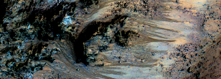
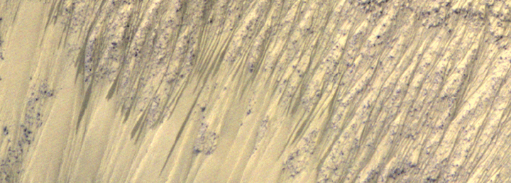
Heavily dissected hill in Juventae Chasm  Sequence of 5 HiRISE images of a heavily-dissected (eroded) hill in southern Juventae Chasm, Mars (latitude 4.7 degrees S, longitude 298.6 degrees E). This sequence is from the recently completed Mars Year (31), and RSL were also seen here in Mars Year 28, so they have recurred. The season of these images is late spring to early summer in the southern hemisphere, and include perihelion (Mars closest to the sun in its orbit). Activity is strongly concentrated on the south-facing slopes, which are the warmest slopes this time of year. The RSL are closely associated with “small” (for Mars) gullies. Images reduced to 1 m/pixel scale. (31MB)
RSL and darkening fans in East Coprates Chasm  Sequence of 6 images showing a small area of steep slopes with RSL activity (latitude 14.7 degrees S, longitude 304.6 degrees E). The sequence is in Mars Year 31, southern spring. Note that some of the fans that RSL flow over became darker and brighter over time (see also figure S2 of the supplementary material of the Nature Geoscience paper). There are many other such fans in this region that darkened and brightened at the same times. Image 0.25 m/pixel scale; scene 480 meters wide. (18MB)
RSL follow the sun in crater on Melas Chasm floor  Sequence of 8 images showing RSL forming first on the north-facing slope (bottom), then switching to the south-facing slope (top). This change occurred close to when the subsolar latitude moved from the north to the south of the latitude of this crater. In other words, RSL are most active on the slopes that receive more direct sunlight. There was also an episode of inactivity and fading of RSL on the south-facing slope, when the air over this region was especially dusty (Ls 235-246). Dusty air makes the daytime temperatures cooler, which may have temporarily stopped the RSL activity. (42MB)
RSL activity on complex topography in East Coprates Chasm  The use of digital terrain maps (DTMs), constructed from HiRISE stereo images, helps characterize the RSL phenomena. The images in other sequences have been DTM-projected to looking straight down on the surface, but here that have been projected to a view a person or rover on the surface could observe. This sequence of 6 DTM-projected images shows RSL forming and fading on west-facing slopes in east Coprates Chasma (latitude 14.7 degrees S, longitude 304.6 degrees E). North is to the left, and most slopes face south. Flows appear to form from the upper-most 100 meters along this ridge, suggesting very concentrated sources, possibly from the light- and mid-toned bedrock. Activity here is observed on all slope aspects and for the majority of the year, but RSL generally favor Sun-facing slopes. (13MB)
RSL and colorful fans along Coprates ridge  This site along Coprates ridge shows RSL on generally north-facing slopes in northern summer/southern winter (latitude 12.9 degrees S, longitude 295.5 degrees E). South is down, and most slopes face northwest. IRB color (near-infrared, red, and blue-green bandpasses displayed as red, green, and blue, respectively) with a min-max stretch illustrates the “greenish” fans and deposits associated with RSL. Two of these fans transition downslope into ripples (see also figure 2 of the Nature Geoscience paper). All of the lineae here and in the larger scene appear to originate from relatively bright bedrock outcrops. Note that some of the fans that RSL flow over became darker and brighter over time. Image is approximately 950 meters wide.
Animated GIF captions by: Matt Chojnacki and Alfred McEwen
Prolonged Magmatic Activity on Mars Inferred from the Detection of Felsic Rocks
Abstract
Rocks dominated by the silicate minerals quartz and feldspar are abundant in Earth's upper continental crust. Yet felsic rocks have not been widely identified on Mars, a planet that seems to lack plate tectonics and the associated magmatic processes that can produce evolved siliceous melts on Earth. If Mars once had a feldspar-rich crust that crystallized from an early magma ocean such as that on the Moon, erosion, sedimentation and volcanism have erased any clear surface evidence for widespread felsic materials. Here we report near-infrared spectral evidence from the Compact Reconnaissance Imaging Spectrometer for Mars onboard the Mars Reconnaissance Orbiter for felsic rocks in three geographically disparate locations on Mars. Spectral characteristics resemble those of feldspar-rich lunar anorthosites, but are accompanied by secondary alteration products (clay minerals). Thermodynamic phase equilibrium calculations demonstrate that fractional crystallization of magma compositionally similar to volcanic flows near one of the detection sites can yield residual melts with compositions consistent with our observations. In addition to an origin by significant magma evolution, the presence of felsic materials could also be explained by feldspar enrichment by fluvial weathering processes. Our finding of felsic materials in several locations on Mars suggests that similar observations by the Curiosity rover in Gale crater may be more widely applicable across the planet.
Quelle: University of Arizona, HiRISE Operations Center