
28.03.2024
A team of European scientists have published the most detailed geological map of Oxia Planum – the landing site for ESA’s Rosalind Franklin rover on Mars. This thorough look at the geography and geological history of the area will help the rover scout the once water-rich terrain, in the search for signs of past and present life.
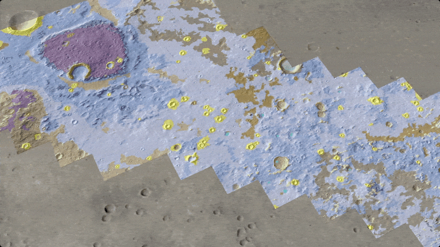
The map gives scientists a head start before Rosalind Franklin lands there in 2030. Four years in the making, this map identifies 15 units with characteristic geological features that can help decide how the rover explores the area, interprets its surroundings, and tries to collect evidence of primitive life.
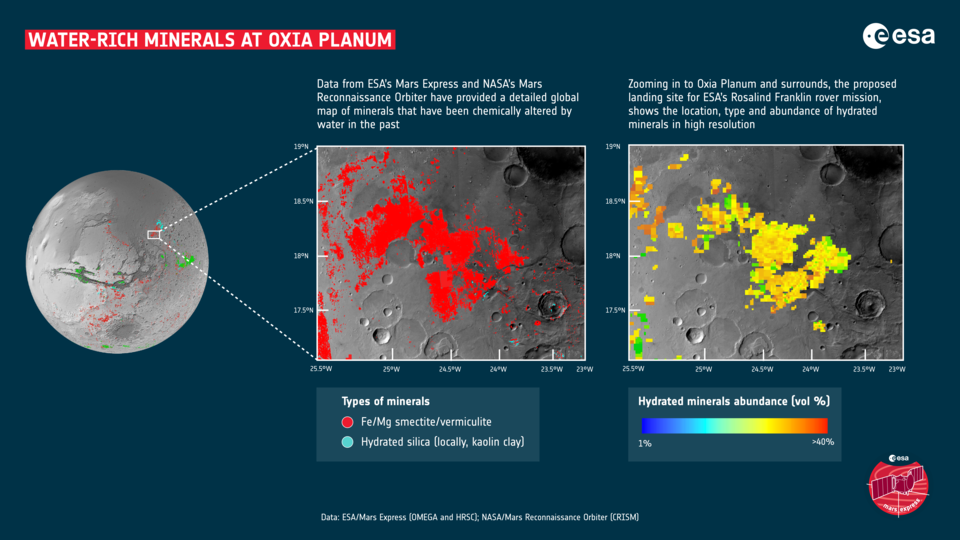
Oxia Planum is located near the martian equator and contains sedimentary deposits that are nearly four billion years old. On a geological scale, this will be the oldest landing site visited by a rover on Mars. The region is rich in clay minerals formed in the presence of water. These rocks are ideal for preserving evidence of the earliest life forms. This makes it an excellent location to look for clues as to whether life once existed on the Red Planet.
Mapping science community
During COVID lockdowns, the Rosalind Franklin science team began an online training programme for around 80 volunteers to map the chosen landing site.
The work was divided into 134 one-square-kilometre areas, so that the team could fully cover the estimated landing area. Scientists used a web-based system that allowed everyone to work on the map in parallel. The software was provided by NASA’s Jet Propulsion Laboratory and set up at ESA.
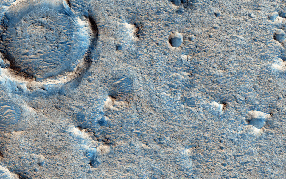
Data came from the Colour and Stereo Surface Imaging System (CaSSIS) onboard the ExoMars Trace Gas Orbiterand several instruments on NASA’s Mars Reconnaissance Orbiter (MRO), including the HiRISE camera, which returns images from Mars orbit at 25 cm per pixel.
The mapping leads then pieced together the information on all the areas to form a coherent map that shows the geology of the landing site in unprecedented detail. The map includes the main types of bedrock, and structures with distinct shapes like ridges and craters. It even features the material that rests on top, for example blown by the wind, or thrown long distances when meteorites impacted the surface.
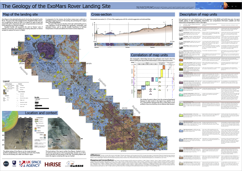
Oxia Planum geological map with legend
The result is the highest resolution map of Oxia Planum yet, created at a scale of 1:25 000, by which every centimetre equals 250 metres on the martian surface. An average drive of 25 to 50 metres a day for Rosalind Franklin would be one to two milimetres on the map.
The map has been published in the Journal of Maps, along with a scientific paper that includes observations and interpretations of each geological unit and will soon be followed by a second publication exploring what these geological units mean for scientists ideas about what the environment of ancient Mars was like.
Why a map for Mars
The exercise familiarised scientists from different teams with the geology and geography of the landing site years before the rover starts operating on Mars. The Rosalind Franklin science team now has a better idea of potential science targets, the type of terrain the rover will be facing and some hazards on its path.
“This map is exciting because it is a guide that shows us where to find the answers. It serves as a visual hypothesis of what we currently know about the different rocks in the landing site. The instruments on Rosalind Franklin will allow us to test our knowledge on the spot when the time comes,” explains Peter Fawdon, one of the lead authors from the Open University.
ESA’s Rosalind Franklin rover is equipped to search for evidence of past and present life on Mars thanks to its drill and scientific instruments. It will allow science teams on Earth to plan the strategy for Rosalind Franklin’s daily expeditions on Mars as they identify the best place to drill below the harsh radiation environment and daily swings in surface temperature.
Rosalind Franklin will be the first rover to drill two metres below the surface, acquiring samples from where there are higher chances of preservation for biosignatures than on the surface and analysing them with its onboard laboratory.
Quelle: ESA