
.
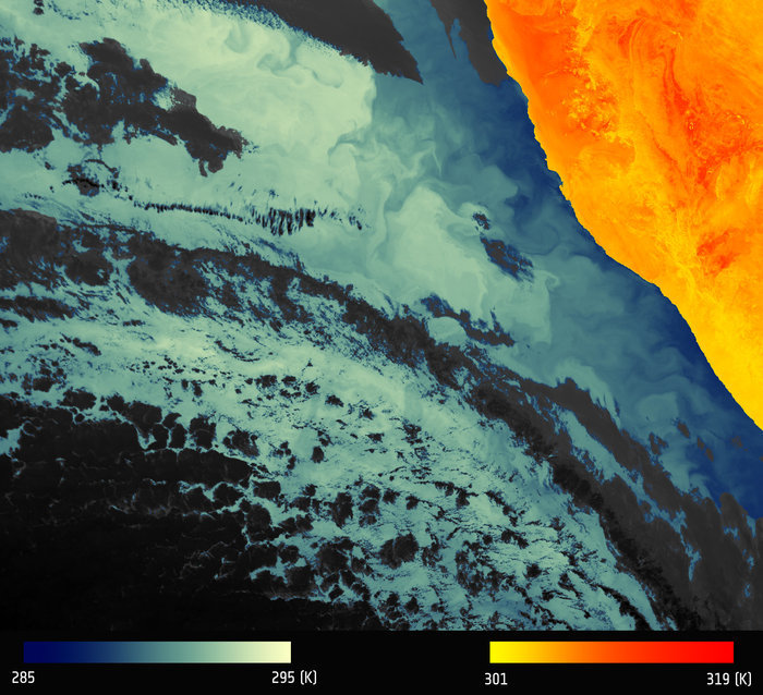
Thermal signature of Namibian coastline
.
Despite only being in orbit a matter of weeks, Sentinel-3A has already delivered some impressive first images. With the thermal-infrared channels now turned on, the satellite completes its set of firsts with a view of ocean features off the coast of Namibia.
Arguably the most comprehensive of all the Copernicus Sentinel missions, Sentinel-3A carries a suite of state-of-the-art instruments to systematically measure the temperature of Earth’s oceans, land, ice and atmosphere.
Sentinel-3 measurements like this will be used to monitor and understand large-scale global dynamics and provide critical information for ocean and weather forecasting.
The Sea and Land Surface Temperature Radiometer is particularly sophisticated, measuring energy radiating from Earth’s surface in nine spectral bands.
By accurately measuring temperature changes, the radiometer will, for example, make an important contribution to monitoring large-scale events such as El Niño.
The very first images came from its optical channels. Before the thermal-infrared channels could be turned on they had to go through a decontamination process to ensure the highest-quality measurements.
The first image from these channels shows thermal signatures over a part of western Namibia and the South Atlantic Ocean.
This image shows the ‘brightness temperature’, which corresponds to radiation emitted from the surface. Further processing is needed to remove the effects of the atmosphere and account for the characteristics of the surface to turn this into an actual surface temperature map.
Cold water is seen along the Namibian coast upwelling from deeper waters. The Benguela current flows north along the west coast of South Africa driven by southeasterly winds, creating coastal upwelling.
Many eddies and meanders are generated in this complex system and these small-scale features are captured beautifully. Understanding changes in the pattern of these waters is important for fisheries, for example.
Over land, the distinct folds of desert dunes can be seen. In fact, further north, Gobabeb is the location of a land-surface temperature validation site – chosen because of its featureless arid nature and lack of vegetation. The site will be instrumental for monitoring the accuracy of the sensor during its mission.
Susanne Mecklenburg, ESA’s Sentinel-3A mission manager, said, “It is still early days, but the data already look good and we are confident that we will be able to provide high-accuracy surface temperature products so that fine thermal structure both over land and over sea can be detected.
“It’s extremely satisfying to see that all of the satellite’s instruments are working well and we can be proud of the European industry and technology that makes it possible.”
Hilary Wilson, EUMETSAT’s Sentinel-3 Project Manager, added, “It is very exciting to see all the small-scale thermal features clearly captured in the Benguela region and this really demonstrates the potential of the Sea and Land Surface Temperature Radiometer.
.
The Sentinel-3 radiometer will provide sea-surface temperature measurements in near-real time. These measurements are needed by operational oceanographic and weather forecasting centres.
.
“With dual-view measurement capability, it will be used to derive accurate surface temperature, a key parameter at the ocean–atmosphere boundary. Therefore, it is important for both operational oceanography and meteorology, and ultimately for long-term climate monitoring.
“We are now looking forward to being able to provide these data to the oceanography and meteorology communities, as well to all citizens and decision-makers, for maximum data exploitation.”
While the instrument’s thermal channels will measure the temperature of the land and sea surface, it also includes dedicated channels for measuring fires. This capability along with the satellite’s Ocean and Land Colour Instrument will help to map carbon emissions from burnt biomass and to assess damage and estimate recovery of burned areas.
Quelle: ESA
4261 Views