
Ground monitoring of a Yuanzheng-1 upper stage deploying a pair of Beidou-3 satellites, launched on November 5, 2017.


12.02.2018
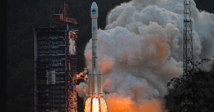
Monday saw the seventh orbital launch of the year by China, with a Long March-3B/YZ-1 orbiting a new pair of navigation satellites. The launch took place just after 05:00 UTC from the LC2 Launch Complex of the Xichang Satellite Launch Center, Sichuan province. It took over four hours to complete the mission.
It is expected that the Beidou-3MEO3 (Beidou-28) and Beidou-3MEO4 (Beidou-29) satellites were onboard. The MEO satellites are the Medium Earth Orbit component of the third phase of the Chinese Beidou (Compass) satellite navigation system. The satellites are part of a fleet that will expand the system to a global navigation coverage.
The satellites are using a new bus that features a phased array antenna for navigation signals and a laser retroreflector, with a launch mass 1,014 kg. Spacecraft dimensions are noted to be 2.25 by 1.0 by 1.22 meters. Usually, the satellites reside in a 21,500 – 21,400 km nominal orbit at 55.5 degrees.
The previous launch on the series took place on January 12th, when the Long March-3B/Y1 (Y45/Y5) launch vehicle orbited the Beidou-3MEO7 (Beidou-26) and Beidou-3MEO8 (Beidou-27) satellites. On November 5, 2017, the Long March-3B/Y1 (Y46/Y4) orbited the Beidou-3MEO1 (Beidou-24) and the Beidou-3MEO2 (Beidou-25) satellites.

BeiDou-3 satellite, as rendered by J Huart.
In March another Long March-3B/Y1 launch vehicle should orbit the Beidou-3MEO5 (Beidou-30) and the Beidou-3MEO6 (Beidou-31) satellites.
The Beidou Phase III system includes the migration of its civil Beidou 1 or B1 signal from 1561.098 MHz to a frequency centered at 1575.42 MHz – the same as the GPS L1 and Galileo E1 civil signals – and its transformation from a quadrature phase shift keying (QPSK) modulation to a multiplexed binary offset carrier (MBOC) modulation similar to the future GPS L1C and Galileo’s E1.
The Phase II B1 open service signal uses QPSK modulation with 4.092 megahertz bandwidth centered at 1561.098 MHz.
The current Beidou constellation spacecraft are transmitting open and authorized signals at B2 (1207.14 MHz) and an authorized service at B3 (1268.52 MHz).
Real-time, stand-alone Beidou horizontal positioning accuracy was classed as better than 6 meters (95 percent) and with a vertical accuracy better than 10 meters (95 percent).
The Compass Navigation Satellite System (CNSS) is China’s satellite navigation system, approved by the Chinese government in 2004, capable of providing continuous, real-time passive 3D geo-spatial positioning and speed measurement.
The Chinese navigation system is being developed and deployed in three phases. Phase 1 (starting in 2003), consisted of an experimental regional navigation system, BeiDou-1, which provided active navigation service.
Phase 2 (started in 2012), consisted of a reduced satellite constellation and provides open service over China. This phase aimed at deploying a system with passive positioning and timing capability over a regional area.
Phase 3 aims for full operational capability by 2020 with a constellation of 27 MEOs plus 5 GEOs and the existing 3 IGSOs satellites of the regional system. CNSS would provide global navigation services, similarly to the GPS, GLONASS or Galileo systems.
CNSS is expected to support two different kinds of general services: RDSS and RNSS. In the Radio Determination Satellite Service (RDSS), the user position is computed by a ground station using the round trip time of signals exchanged via GEO satellite. The RDSS long-term feature further includes short message communication (guaranteeing backward compatibility with Beidou-1), large volume message communication, information connection, and extended coverage.
The Radio Navigation Satellite Service (RNSS) is very similar to that provided by GPS and Galileo and is designed to achieve similar performances.
The long-term goal is to develop a global navigation satellite network similar to the GPS and GLONASS by 2020 eventually consisting a constellation of 35 vehicles, including 27 MEO (21,500 km orbits) satellites, three IGSO satellites (inclined at 55 degrees) and five GSO satellites.
The system will be dual-use, based on a civilian service that will provide an accuracy of 10 meters in the user position, 0.2 m/s on the user velocity and 50 nanoseconds in time accuracy; and the military and authorized user’s service, providing higher accuracies. The first phase of the project will involve coverage of the Chinese territory. However, the future Compass constellation will cover the entire globe.
This mission is also the second flight of the Long March-3B/YZ-1 (Chang Zheng-3B/YZ-1) version of the Long March-3B.

Long March 3B – via ChinaNews.com
The launcher was developed from the Chang Zheng-3A. The CZ-3B features enlarged launch propellant tanks, improved computer systems, a larger 4.2 meter diameter payload fairing and the addition of four strap-on boosters in the core stage that provide additional help during the first phase of the launch.
The rocket is capable of launching an 11,200 kg satellite to a low Earth orbit or a 5,100 kg cargo to a geosynchronous transfer orbit.
The CZ-3B/G2 (Enhanced Version) launch vehicle was developed from the CZ-3B, increasing the GTO capacity up to 5,500kg. The CZ-3B/E has nearly the same configurations with CZ-3B bar its enlarged core stage and boosters.
On May 14, 2007, the first flight of CZ-3B/G2 was performed successfully, accurately sending the NigcomSat-1 into pre-determined orbit. With the GTO launch capability of 5,500kg, CZ-3B/G2 is dedicated for launching heavy GEO communications satellite.
The rocket structure also combines all sub-systems together and is composed of four strap-on boosters, a first stage, a second stage, a third stage and payload fairing.
The first two stages, as well as the four strap-on boosters, use hypergolic (N2O4/UDMH) fuel while the third stage uses cryogenic (LOX/LH2) fuel. The total length of the CZ-3B is 54.838 meters, with a diameter of 3.35 meters on the core stage and 3.00 meters on the third stage.

Long March 3B
On the first stage, the CZ-3B uses a YF-21C engine with a 2,961.6 kN thrust and a specific impulse of 2,556.5 Ns/kg. The first stage diameter is 3.35 m and the stage length is 23.272 m.
Each strap-on booster is equipped with a YF-25 engine with a 740.4 kN thrust and a specific impulse of 2,556.2 Ns/kg. The strap-on booster diameter is 2.25 m and the strap-on booster length is 15.326 m.
The second stage is equipped with a YF-24E (main engine – 742 kN / 2,922.57 Ns/kg; four vernier engines – 47.1 kN / 2,910.5 Ns/kg each). The second stage diameter is 3.35 m and the stage length is 12.920 m.
The third stage is equipped with a YF-75 engine developing 167.17 kN and with a specific impulse of 4,295 Ns/kg. The fairing diameter of the CZ-3B is 4.00 meters and has a length of 9.56 meters.
The Yuanzheng-1 (“Expedition-1″) uses a small thrust 6.5 kN engine burning UDMH/N2O4 with a specific impulse at 3,092 m/s. The upper stage should be able to conduct two burns, having a 6.5 hour lifetime and is capable of achieving a variety of orbits.
It will be adapted for use on the CZ-3A/B/C series mainly for direct MEO/GEO insertion missions (mostly for the navigation satellites of the Beidou GNSS).

A previous Long March 3B launch via the control center.
The typical flight sequence for the LM-3B launch vehicle in a standard GTO mission starts with the ignition of the first stage engines together with the ignition of the four liquid strap-on boosters. General launch profile sees the launch vehicle doing the pitch over maneuver at 10 seconds after leaving the launch platform. At two minutes 27 seconds into the flight, boosters shutdown occurs and separation follows one second later.
First stage shutdown takes place at 2 minutes 25 seconds, and stage separation two seconds later with the second stage ignition. The separation of the fairing occurs 3 minutes 35 seconds into the flight.
Second stage main engine shutdown takes place 5 minutes and 25 seconds into the flight and second stage Vernier engines shutdown takes place five seconds later, followed by the separation between the second and the third stage, and third stage first ignition.
This will end at 10 minutes 16 seconds into the flight. At this time begins a coast phase that ends 20 minutes 58 seconds after launch with the second ignition of the third stage. This ends three minutes later, starting then a 20 seconds velocity adjustment phase. Separation of the cargo usually takes place 25 minutes 38 seconds after launch.
The Xichang Satellite Launch Centre is situated in the Sichuan Province, south-western China and is the country’s launch site for geosynchronous orbital launches.

Xichang Satellite Launch Center.
Equipped with two launch pads (LC2 and LC3), the center has a dedicated railway and highway lead directly to the launch site.
The Command and Control Centre is located seven kilometers south-west of the launch pad, providing flight and safety control during launch rehearsal and launch.
Other facilities on the Xichang Satellite Launch Centre are the Launch Control Centre, propellant fuelling systems, communications systems for launch command, telephone and data communications for users, and support equipment for meteorological monitoring and forecasting.
The first launch from Xichang took place at 12:25UTC on January 29, 1984, when the Chang Zheng-3 (CZ3-1) was launched the Shiyan Weixing (14670 1984-008A) communications satellite into orbit.
A new satellite in the Ludikancha Weixing series should be riding into orbit at the end of February from the Jiuquan Satellite Launch Center.
The Ludikancha Weixing satellites are very high-resolution earth observation satellites. Operating in 500 km polar orbits, the satellites are possibly military in nature.
The next launch from the Xichang Satellite Launch Center should take place on March 15 with a Long March-3B/G2 orbiting the APStar-6C communications satellite.
Quelle: NS
+++
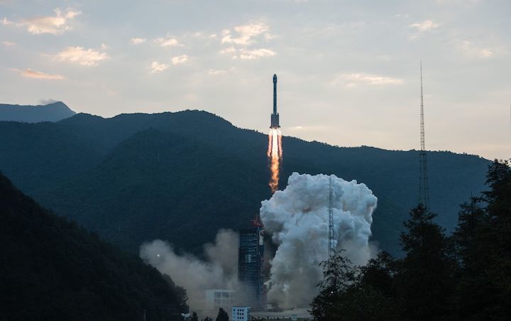
A Long March 3B carrying 2 Beidou navigation satellites lifted off from Xichang, China
Re-Entry von Long March 3B Stufe

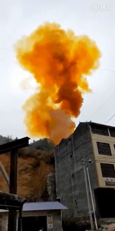
Another near miss in Guangxi following a Long March 3B launch of Beidou satellites from Xichang. This time in Tianlin county.
+++
China on Monday launched a pair of Beidou navigation and positioning satellites to medium Earth orbits, in what was the country's seventh launch of planned record-breaking 2018.
A Long March 3B rocket with a Yuanzheng-1 upper stage lifted off from the Xichang Satellite Launch Centre among hills of the Sichuan Province at 13:03 local time (05:03 UTC).
Success of the mission was confirmed by China's main space contractor some four hours after launch, following insertion of the satellites into their intended orbits, around 21,000 km above the Earth.
The launch had been set for the same window on Sunday, but was delayed by the visit of Chinese president Xi Jinping to the launch site.
The busy start to the year reflects China's plans to attempt around 40 missions in 2018, including government and commercial launches, with the return-to-flight of the Long March 5 and the Chang'e-4 lunar far side mission as highlights.
Boosters of the Long March 3B launch vehicle fell downrange close to an inhabited area in Tianlin county in Guangxi Zhuang Autonomous Region. The previous such mission saw a dramatic near miss in the same region.

The pair launched today are the 28th and 29th satellites for China's Beidou navigation system, China's answer to the US Global Positioning System (GPS), Russia's GLONASS and Europe's Galileo GNSS constellations.
The satellites are part of a third phase of Beidou deployment, which will take Beidou coverage from regional to covering the countries along the 'Belt and Road' initiative by the end of 2018, and global by 2020.
According to Nasaspaceflight.com, the satellites are using a new bus featuring a phased array antenna for navigation signals and a laser retroreflector, with a launch mass of 1,014 kg.
The accuracy, stability and signal strength of the Beidou-3 satellites is improved over previous versions by developments in atomic clocks, laser communications and inter-satellite links.
Ground monitoring of a Yuanzheng-1 upper stage deploying a pair of Beidou-3 satellites, launched on November 5, 2017.
As well as civilian applications such as navigation for shipping and road traffic, and mapping and surveying, Beidou will provide the People's Liberation Army military assistance from space in targeting, positioning and locating, and synchronising operations.
This was China's second launch of Beidou satellites in 2018, with a previous duo, satellites 26 and 27, launched to medium Earth orbit on January 11. A further launch is expected in March.
Lei Fanpei, chairman of the China Aerospace Science and Technology Group (CASC), said late last year that the construction of the 35-satellite navigation system – with five in geosynchronous orbit, three in inclined geosynchronous orbits, and 27 in lower, medium Earth orbits - is to be completed by 2020.

An illustration demonstrating a number of civil and military uses for Beidou GNSS.
The Long March 3B rocket is used to carry satellites to medium and geosynchronous Earth orbits, and is almost 55 metres long, with a diameter of 3.35 metres on the core stage. The launcher has a mass at liftoff of 458,970 kg, or just over 1 million pounds.
The four 2.25 m diameter, 15 m long strap-on boosters are filled with unsymmetrical dimethylhydrazine (UDMH) and dinitrogen tetroxide (N2O4) hypergolic propellant, which is highly toxic.
The last launch saw a booster fall and explode behind buildings in the town of Xiangdu in Tiandeng County, Guangxi, within the designated drop zone. Today's impacted housing in Tianlin county.