

.
China launches new weather satellite
China successfully launched a meteorological satellite into orbit at 11:07 a.m. Monday, Taiyuan Satellite Launch Center said.
The third Fengyun-III satellite, carried by a Long March-4C carrier rocket, will join the previous two which are in orbit to boost China's weather monitoring capabilities.
The three Fengyun-III weather satellites, the country's second generation polar orbiting meteorological satellites, are useful in monitoring natural disasters and the eco-environment. They also provide meteorological information for global climate change studies as well as aviation and navigation.
The network of satellites will also shorten the updating hours of medium-range weather forecasting from 12 to six.
The first and second Fengyun-III were launched in May 2008 and November 2010 respectively.
This marks the 181st launch carried by a Long March rocket, according to the center.
Quelle: XINHUA
.
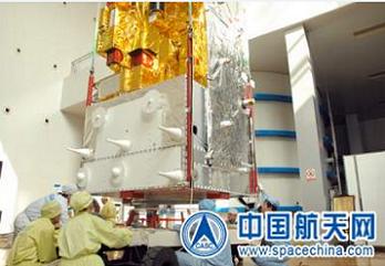
The FY-3 series satellites are designed and developed by the Shanghai Aerospace Administration. The vehicle structure is a hexahedron of 4.4 m x 2.0 m x 2.0 m in the stowed configuration and 4.4 m x 10 m x 3.8 m in the deployed state.
The total spacecraft launch mass is estimated to be 2450 kg.
The satellite structure is based on a separated bay design, combined structure of center supporting cylinder and guest board for service module and propulsion module, and a combined structure of baffle plate and truss. Thermal control relies mainly on passive thermal control assisted by active thermal control.
The satellite features one solar panel mounted on one side of the satellite’s main body – making the span length of the satellite 10m in its flight configuration). The solar array is 22.464 m2 with an output power of 2.48 kW (EOL), average = 1100 W. Two NiCd battery units (36 cells) each of 50 Ah capacity provide power in ecliptic orbit phases.
The attitude control of the satellite employs three-axis stabilization (bias momentum control) with a pointing precision of 50 m on the ground. The ADCS (Attitude Determination and Control Subsystem) employs a star sensor for attitude sensing.
The FY-3 bus contains three major modules: a service module, a payload module, and a propulsion module. The spacecraft design life is three years.
The ground swath of the onboard optical-mechanical scanners is 3,000 km with a 250 m resolution in the High Resolution Picture Transmission (HRPT) mode. The satellite has two X-band transmitters (one real-time and one delayed) and an L-band transmitter (real-time).
The onboard data management computer, altitude and orbital control computer – and all the remote-sensing sensors – were connected via a MIL-STD-1553B data bus system, which allows autonomous management of data collection and calculating of orbital parameters by the onboard computers.
The instruments on board the satellites can be divided on three missions: sounding, ozone and imaging. The instruments used for sounding are the IRAS (Infrared Atmospheric Sounder), the MWTS (Microwave Temperature Sounder) and the MWHS (Microwave Humidity Sounder).
The IRAS is used to obtain atmospheric temperature profiles, atmospheric humidity profiles, to determine total ozone content, cirrus, aerosol, etc. The MWTS is used for atmospheric temperature profile, rainfall, cloud liquid water, surface parameters, etc. Finally, the MWHS is used for Atmospheric humidity profile, water vapor, rainfall, cloud liquid water, etc.
The instruments used for the ozone mission are the TOU (Total Ozone Unit) the SBUS (Solar Backscatter Ultraviolet Sounder). The TOU is used to determine the total ozone distribution, while SBUS is used for determine the ozone profile and the total ozone amount.
Finally, the instruments that are used for imaging are the VIRR (Visible and Infrared Radiometer), the MERSI (Medium Resolution Spectral Imager) and the MWRI Microwave Radiation Imager).
NSMC and CMA are responsible for receiving, processing the data of Chinese and foreign meteorological satellites, and distributing the data and information products to users for application. Other responsibilities include establishing the ground segment of the Chinese meteorological satellite observation system, conducting applied research in satellite meteorology, making plans and programs for developing Chinese meteorological satellite system based on the national requirements.
The FY-3 ground segment is comprised with five receiving stations. One of the stations is located on Kiruna, Sweden. The FY-3 data products will be transmitted via DVB-S (Digital Video Broadcast-Satellite).
Quelle: NS
9174 Views