
.
Damp spots found in supposedly dry Martian tropics
.
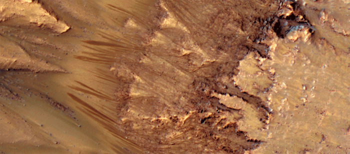
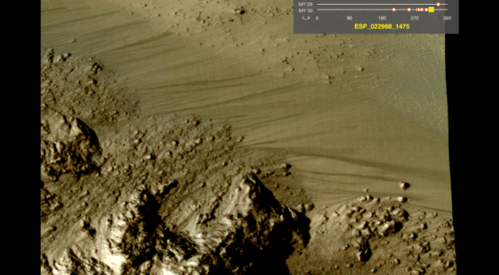
This colour-enhanced image shows the apparently damp streaks on the left-hand side (Image: NASA/JPL/University of Arizona)
.
Dark streaks on sun-warmed slopes hint at unexpected dampness in the Martian tropics. If confirmed, the discovery would mean that water on Mars is more widespread than imagined – possibly adding a wrinkle to efforts to protect Mars from contamination with earthly life forms.
Previous images taken from orbit showed similar streaks that appear to be moving down slopes in the planet's southern mid-latitudes. These dark spots appeared in sunny areas in late spring and summer then faded away, leading scientists to conclude that briny ice under the surface was melting, and that liquid water was seeping up and evaporating.
The latest pictures have doubled the number of southern sites with streaks and added some closer to the equator, most in the deep canyons of Valles Marineris. These dark spots also appear on sunny slopes and then vanish.
"As something that wets and dries again, water is a very attractive explanation," says Alfred McEwen at the University of Arizona in Tucson.
Damp surprise
Water ice wasn't expected to exist in the Martian tropics, where temperatures get high enough that even buried ice should have been vaporised. Small amounts of water might be condensing from the atmosphere rather than seeping up from ice deposits. Either way, McEwen is convinced that liquid water is somehow involved. "No one has come up with a good alternative model," he says.
The fresh evidence for seasonal streaks bolsters the case for briny liquids at work on Mars, says James Head at Brown University in Providence, Rhode Island, who was not involved in the study. Water at the equator would be very surprising, he adds, but it is possible some ice may remain under protective soil cover.
And that may force a rethink of future exploration plans, says McEwen. While spacecraft headed to Mars are carefully sterilised before launch, there is a risk that hardy hitchhiking microbes could make it all the way to the planet's surface. A 2008 report had concluded that tropical Mars is too dry for terrestrial life to survive there, making it a relatively safe landing zone. Evidence of recurring damp spots in the Martian tropics could change that assessment, says McEwen.
Quelle: Nature Geoscience
.
Water seems to flow freely on Mars
Any areas of water could be off-limits to all but the cleanest spacecraft. Frams: NASA
.
.
.
.
.
.
.
.
Quelle: NASA
.
NASA-Raumsonde HIRISE enthüllt einen dynamischeren roten Planeten
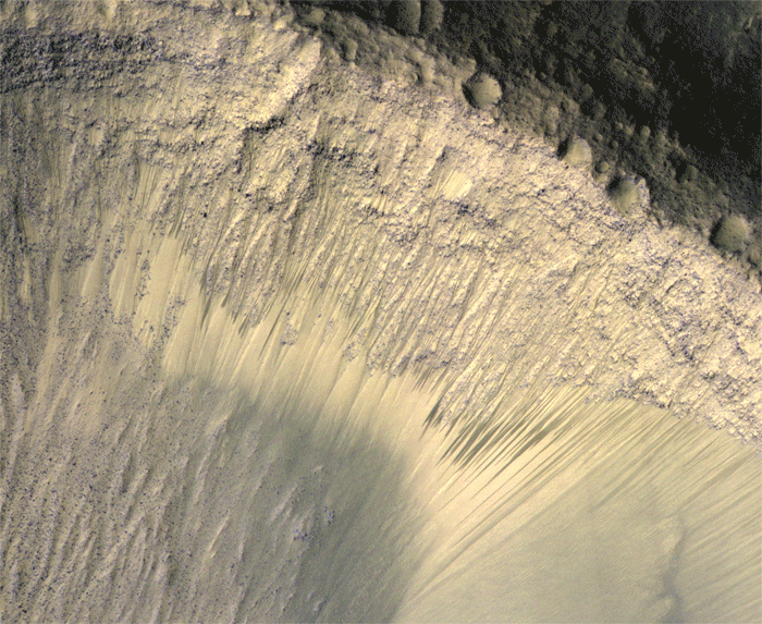
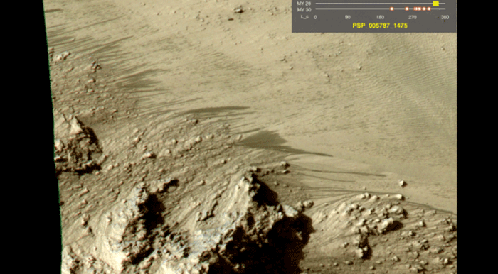
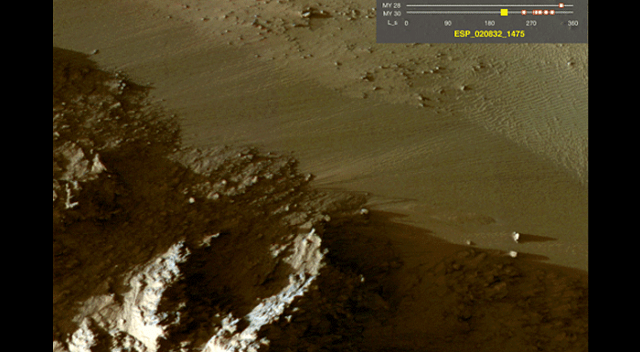
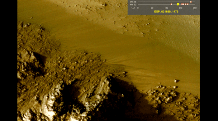
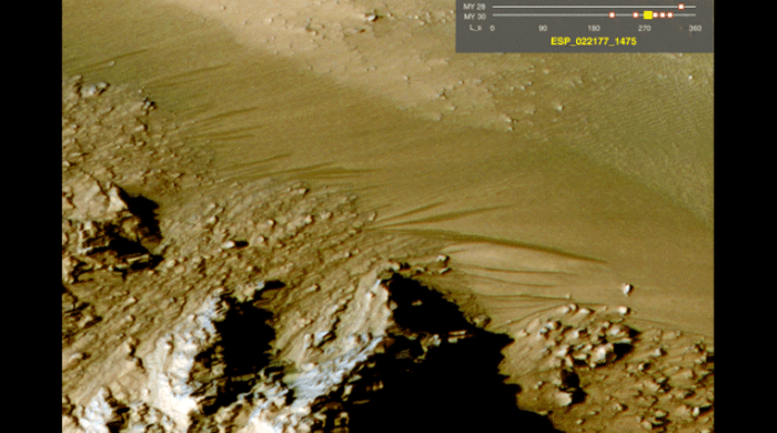
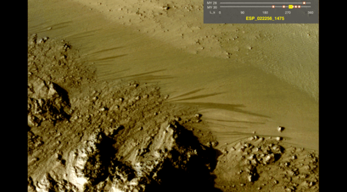
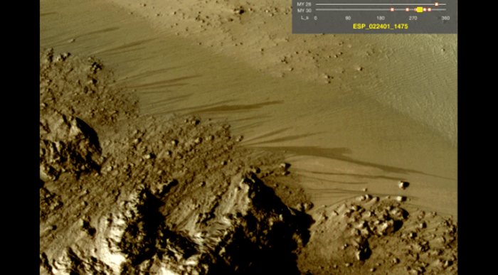
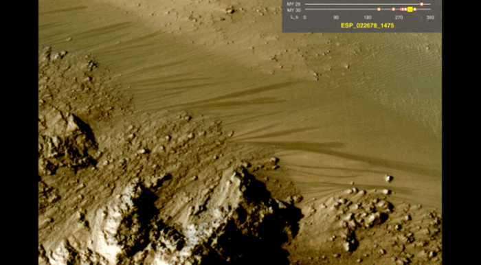
These images from the High Resolution Imaging Science Experiment (HiRISE) camera on NASA's Mars Reconnaissance Orbiter show how the appearance of dark markings on Martian slope changes with the seasons.
Image Credit: NASA/JPL-Caltech/Univ. of Arizona
.
NASA's Mars Reconnaissance Orbiter has revealed to scientists slender dark markings -- possibly due to salty water – that advance seasonally down slopes surprisingly close to the Martian equator.
"The equatorial surface region of Mars has been regarded as dry, free of liquid or frozen water, but we may need to rethink that," said Alfred McEwen of the University of Arizona in Tucson, principal investigator for the Mars Reconnaissance Orbiter (MRO) High Resolution Imaging Science Experiment (HiRISE) camera.
Tracking how these features recur each year is one example of how the longevity of NASA orbiters observing Mars is providing insight about changes on many time scales. Researchers at the American Geophysical Union meeting Tuesday in San Francisco discussed a range of current Martian activity, from fresh craters offering glimpses of subsurface ice to multi-year patterns in the occurrence of large, regional dust storms.
The seasonally changing surface flows were first reported two years ago on mid-latitude southern slopes. They are finger-like features typically less than 16 feet (5 meters) wide that appear and extend down steep, rocky slopes during spring through summer, then fade in winter and return the next spring. Recently observed slopes stretch as long as 4,000 feet (1,200 meters).
McEwen and co-authors reported the equatorial flows at the conference and in a paper published online Tuesday by Nature Geoscience. Five well-monitored sites with these markings are in Valles Marineris, the largest canyon system in the solar system. At each of these sites, the features appear on both north- and south-facing walls. On the north-facing slopes, they are active during the part of the year when those slopes get the most sunshine. The counterparts on south-facing slopes start flowing when the season shifts and more sunshine hits their side.
"The explanation that fits best is salty water is flowing down the slopes when the temperature rises," McEwen said. "We still don't have any definite identification of water at these sites, but there's nothing that rules it out, either."
Dissolved salts can keep water melted at temperatures when purer water freezes, and they can slow the evaporation rate so brine can flow farther. This analysis used data from the Compact Reconnaissance Imaging Spectrometer for Mars and the Context Camera on the MRO as well as the Thermal Emission Imaging System experiment on NASA's Mars Odyssey orbiter.
Water ice has been identified in another dynamic process researchers are monitoring with MRO. Impacts of small asteroids or bits of comets dig many fresh craters on Mars every year. Twenty fresh craters have exposed bright ice previously hidden beneath the surface. Five were reported in 2009. The 15 newly reported ones are distributed over a wider range of latitudes and longitudes.
"The more we find, the more we can fill in a global map of where ice is buried," said Colin Dundas of the U.S. Geological Survey in Flagstaff, Ariz. "We've now seen icy craters down to 39 degrees north, more than halfway from the pole to the equator. They tell us that either the average climate over several thousand years is wetter than present or that water vapor in the current atmosphere is concentrated near the surface. Ice could have formed under wetter conditions, with remnants from that time persisting today, but slowly disappearing."
Mars' modern climate becomes better known each year because of a growing set of data from a series of orbiters that have been studying Mars continually since 1997. That has been almost nine Martian years because a year on Mars is almost two years long on Earth. Earlier missions and surface landers have added insight about the dynamics of Mars' atmosphere and its interaction with the ground.
"The dust cycle is the main driver of the climate system," said Robert Haberle of NASA's Ames Research Center in Moffett Field, Calif.
One key question researchers want to answer is why dust storms encircle Mars in some years and not in others. These storms affect annual patterns of water vapor and carbon dioxide in the atmosphere, freezing into polar ice caps in winter and replenishing the atmosphere in spring. Identifying significant variations in annual patterns requires many Martian years of observations.
The data emerging from long-term studies will help future human explorers of Mars know where to find resources such as water, how to prepare for hazards such as dust storms, and where to be extra careful about contamination with Earth microbes.
Launched in 2005, Mars Reconnaissance Orbiter and its six instruments have provided more high-resolution data about the Red Planet than all other Mars orbiters combined. Data are made available for scientists worldwide to research, analyze and report their findings.
NASA's Jet Propulsion Laboratory in Pasadena, Calif., manages the MRO and Mars Odyssey missions for NASA's Science Mission Directorate in Washington. Lockheed Martin Space Systems in Denver built both orbiters. The University of Arizona Lunar and Planetary Laboratory operates the HiRISE camera, which was built by Ball Aerospace & Technologies Corp. of Boulder, Colo.
.
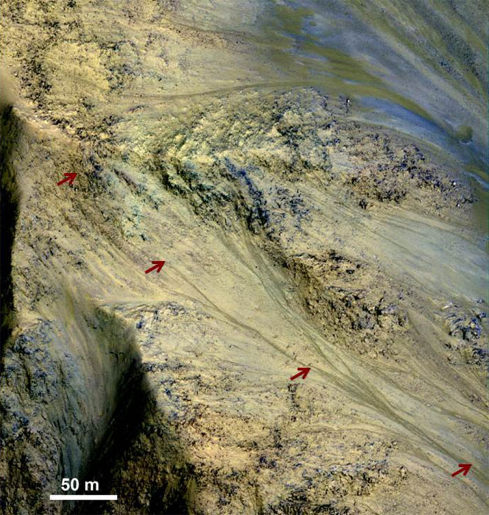
Long, Recurring Linear Marking on Martian Slope
This image includes an especially long example of a type of dark marking that advances down some Martian slopes in warmer months and fades away in cooler months.
The features, called "recurrent slope linea," may be seasonal flows of salty water. Red arrows indicate the location of one on this image taken by the High Resolution Imaging Science Experiment (HiRISE) camera aboard NASA's Mars Reconnaissance Orbiter. This one is three-quarters of a mile (1.2 kilometers) long.
Image credit: NASA/JPL-Caltech/Univ. of Arizona
.
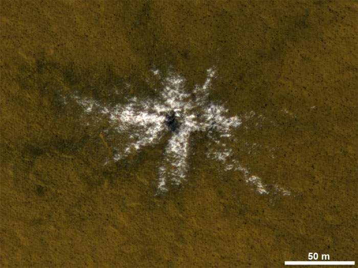
Icy Material Thrown from Cratering Impact on Mars
This image taken on May 19, 2010, shows an impact crater that had not existed when the same location on Mars was previously observed in March 2008. The new impact excavated and scattered water ice that had been hidden beneath the surface. The location is at 63.9 degrees north latitude, 44.9 degrees east longitude. The 50-meter scale bar at lower right is about 55 yards long.
.
Quelle: NASA
5404 Views